
Erosion is the action of surface processes that removes soil, rock, or dissolved material from one location on the Earth's crust and then transports it to another location where it is deposited. Erosion is distinct from weathering which involves no movement. Removal of rock or soil as clastic sediment is referred to as physical or mechanical erosion; this contrasts with chemical erosion, where soil or rock material is removed from an area by dissolution. Eroded sediment or solutes may be transported just a few millimetres, or for thousands of kilometres.

Hydrology is the scientific study of the movement, distribution, and management of water on Earth and other planets, including the water cycle, water resources, and drainage basin sustainability. A practitioner of hydrology is called a hydrologist. Hydrologists are scientists studying earth or environmental science, civil or environmental engineering, and physical geography. Using various analytical methods and scientific techniques, they collect and analyze data to help solve water related problems such as environmental preservation, natural disasters, and water management.
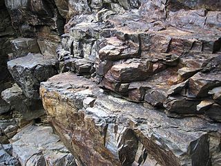
Soil erosion is the denudation or wearing away of the upper layer of soil. It is a form of soil degradation. This natural process is caused by the dynamic activity of erosive agents, that is, water, ice (glaciers), snow, air (wind), plants, and animals. In accordance with these agents, erosion is sometimes divided into water erosion, glacial erosion, snow erosion, wind (aeolian) erosion, zoogenic erosion and anthropogenic erosion such as tillage erosion. Soil erosion may be a slow process that continues relatively unnoticed, or it may occur at an alarming rate causing a serious loss of topsoil. The loss of soil from farmland may be reflected in reduced crop production potential, lower surface water quality and damaged drainage networks. Soil erosion could also cause sinkholes.
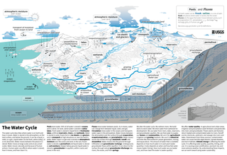
The water cycle is a biogeochemical cycle that involves the continuous movement of water on, above and below the surface of the Earth. The mass of water on Earth remains fairly constant over time. However, the partitioning of the water into the major reservoirs of ice, fresh water, salt water and atmospheric water is variable and depends on climatic variables. The water moves from one reservoir to another, such as from river to ocean, or from the ocean to the atmosphere. The processes that drive these movements are evaporation, transpiration, condensation, precipitation, sublimation, infiltration, surface runoff, and subsurface flow. In doing so, the water goes through different forms: liquid, solid (ice) and vapor. The ocean plays a key role in the water cycle as it is the source of 86% of global evaporation.

Hydrogeology is the area of geology that deals with the distribution and movement of groundwater in the soil and rocks of the Earth's crust. The terms groundwater hydrology, geohydrology, and hydrogeology are often used interchangeably, though hydrogeology is the most commonly used.
Ecohydrology is an interdisciplinary scientific field studying the interactions between water and ecological systems. It is considered a sub discipline of hydrology, with an ecological focus. These interactions may take place within water bodies, such as rivers and lakes, or on land, in forests, deserts, and other terrestrial ecosystems. Areas of research in ecohydrology include transpiration and plant water use, adaption of organisms to their water environment, influence of vegetation and benthic plants on stream flow and function, and feedbacks between ecological processes, the soil carbon sponge and the hydrological cycle.

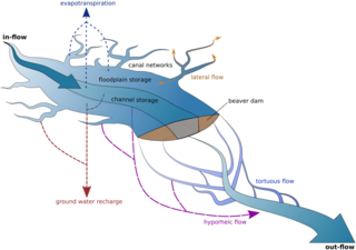
Infiltration is the process by which water on the ground surface enters the soil. It is commonly used in both hydrology and soil sciences. The infiltration capacity is defined as the maximum rate of infiltration. It is most often measured in meters per day but can also be measured in other units of distance over time if necessary. The infiltration capacity decreases as the soil moisture content of soils surface layers increases. If the precipitation rate exceeds the infiltration rate, runoff will usually occur unless there is some physical barrier.
The United States Environmental Protection Agency (EPA) Storm Water Management Model (SWMM) is a dynamic rainfall–runoff–subsurface runoff simulation model used for single-event to long-term (continuous) simulation of the surface/subsurface hydrology quantity and quality from primarily urban/suburban areas.

Surface runoff is the unconfined flow of water over the ground surface, in contrast to channel runoff. It occurs when excess rainwater, stormwater, meltwater, or other sources, can no longer sufficiently rapidly infiltrate in the soil. This can occur when the soil is saturated by water to its full capacity, and the rain arrives more quickly than the soil can absorb it. Surface runoff often occurs because impervious areas do not allow water to soak into the ground. Furthermore, runoff can occur either through natural or human-made processes.

The law of water balance states that the inflows to any water system or area is equal to its outflows plus change in storage during a time interval. In hydrology, a water balance equation can be used to describe the flow of water in and out of a system. A system can be one of several hydrological or water domains, such as a column of soil, a drainage basin, an irrigation area or a city.

An hydrological transport model is a mathematical model used to simulate the flow of rivers, streams, groundwater movement or drainage front displacement, and calculate water quality parameters. These models generally came into use in the 1960s and 1970s when demand for numerical forecasting of water quality and drainage was driven by environmental legislation, and at a similar time widespread access to significant computer power became available. Much of the original model development took place in the United States and United Kingdom, but today these models are refined and used worldwide.
The HBV hydrology model, or Hydrologiska Byråns Vattenbalansavdelning model, is a computer simulation used to analyze river discharge and water pollution. Developed originally for use in Scandinavia, this hydrological transport model has also been applied in a large number of catchments on most continents.
Snow hydrology is a scientific study in the field of hydrology which focuses on the composition, dispersion, and movement of snow and ice. Studies of snow hydrology predate the Anno Domini era, although major breakthroughs were not made until the mid eighteenth century.

Groundwater recharge or deep drainage or deep percolation is a hydrologic process, where water moves downward from surface water to groundwater. Recharge is the primary method through which water enters an aquifer. This process usually occurs in the vadose zone below plant roots and is often expressed as a flux to the water table surface. Groundwater recharge also encompasses water moving away from the water table farther into the saturated zone. Recharge occurs both naturally and through anthropogenic processes, where rainwater and/or reclaimed water is routed to the subsurface.
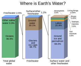
Most water in Earth's atmosphere and crust comes from saline seawater, while fresh water accounts for nearly 1% of the total. The vast bulk of the water on Earth is saline or salt water, with an average salinity of 35‰, though this varies slightly according to the amount of runoff received from surrounding land. In all, water from oceans and marginal seas, saline groundwater and water from saline closed lakes amount to over 97% of the water on Earth, though no closed lake stores a globally significant amount of water. Saline groundwater is seldom considered except when evaluating water quality in arid regions.

A hydrologic model is a simplification of a real-world system that aids in understanding, predicting, and managing water resources. Both the flow and quality of water are commonly studied using hydrologic models.

A stream is a continuous body of surface water flowing within the bed and banks of a channel. Depending on its location or certain characteristics, a stream may be referred to by a variety of local or regional names. Long, large streams are usually called rivers, while smaller, less voluminous and more intermittent streams are known as streamlets, brooks or creeks.
Earth science or geoscience includes all fields of natural science related to the planet Earth. This is a branch of science dealing with the physical, chemical, and biological complex constitutions and synergistic linkages of Earth's four spheres: the biosphere, hydrosphere/cryosphere, atmosphere, and geosphere. Earth science can be considered to be a branch of planetary science but with a much older history.
The following outline is provided as an overview of and topical guide to hydrology:
DPHM-RS is a semi-distributed hydrologic model developed at University of Alberta, Canada.