
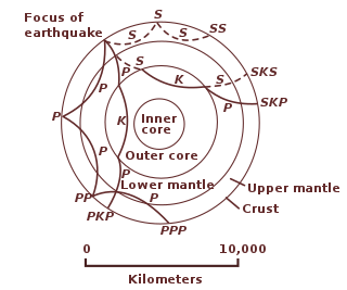
Geophysics is a subject of natural science concerned with the physical processes and physical properties of the Earth and its surrounding space environment, and the use of quantitative methods for their analysis. Geophysicists, who usually study geophysics, physics, or one of the earth sciences at the graduate level, complete investigations across a wide range of scientific disciplines. The term geophysics classically refers to solid earth applications: Earth's shape; its gravitational, magnetic fields, and electromagnetic fields ; its internal structure and composition; its dynamics and their surface expression in plate tectonics, the generation of magmas, volcanism and rock formation. However, modern geophysics organizations and pure scientists use a broader definition that includes the water cycle including snow and ice; fluid dynamics of the oceans and the atmosphere; electricity and magnetism in the ionosphere and magnetosphere and solar-terrestrial physics; and analogous problems associated with the Moon and other planets.

The Royal Astronomical Society (RAS) is a learned society and charity that encourages and promotes the study of astronomy, solar-system science, geophysics and closely related branches of science. Its headquarters are in Burlington House, on Piccadilly in London. The society has over 4,000 members ("Fellows"), most of them professional researchers or postgraduate students. Around a quarter of Fellows live outside the UK.

Geomatics is defined in the ISO/TC 211 series of standards as the "discipline concerned with the collection, distribution, storage, analysis, processing, presentation of geographic data or geographic information". Under another definition, it consists of products, services and tools involved in the collection, integration and management of geographic (geospatial) data. It is also known as geomatic(s) engineering. Surveying engineering was the widely used name for geomatic(s) engineering in the past.

Planetary geology, alternatively known as astrogeology or exogeology, is a planetary science discipline concerned with the geology of celestial bodies such as planets and their moons, asteroids, comets, and meteorites. Although the geo- prefix typically indicates topics of or relating to Earth, planetary geology is named as such for historical and convenience reasons; due to the types of investigations involved, it is closely linked with Earth-based geology. These investigations are centered around the composition, structure, processes, and history of a celestial body.
Exploration geophysics is an applied branch of geophysics and economic geology, which uses physical methods at the surface of the Earth, such as seismic, gravitational, magnetic, electrical and electromagnetic, to measure the physical properties of the subsurface, along with the anomalies in those properties. It is most often used to detect or infer the presence and position of economically useful geological deposits, such as ore minerals; fossil fuels and other hydrocarbons; geothermal reservoirs; and groundwater reservoirs. It can also be used to detect the presence of unexploded ordnance.

Geoscience Australia is an agency of the Australian Government. It carries out geoscientific research. The agency is the government's technical adviser on all aspects of geoscience, and custodian of the geographic and geological data and knowledge of the nation.

Magnetotellurics (MT) is an electromagnetic geophysical method for inferring the earth's subsurface electrical conductivity from measurements of natural geomagnetic and geoelectric field variation at the Earth's surface.

Zykov Glacier is a valley glacier in northern Victoria Land, Antarctica, east of Saddle Peak and Mount Kostka in the Anare Mountains. It is about 25 miles (40 km) long, and flows northwest, reaching the Pennell Coast between Cape Williams and Cooper Bluffs. Photographed by the Soviet Antarctic Expedition from the survey ship Ob in 1958, it was named by them for student navigator Ye. Zykov, who died in Antarctica, February 3, 1957.
The Jackson School of Geosciences at The University of Texas at Austin unites the Department of Geological Sciences with two research units, the Institute for Geophysics and the Bureau of Economic Geology.

Henryk Arctowski, born Henryk Artzt, was a Polish scientist and explorer.

In geophysics, a magnetic anomaly is a local variation in the Earth's magnetic field resulting from variations in the chemistry or magnetism of the rocks. Mapping of variation over an area is valuable in detecting structures obscured by overlying material. The magnetic variation in successive bands of ocean floor parallel with mid-ocean ridges was important evidence for seafloor spreading, a concept central to the theory of plate tectonics.
The International Association of Geomagnetism and Aeronomy (IAGA) is an international scientific association that focuses on the study of terrestrial and planetary magnetism and space physics.
Geomathematics is the application of mathematical methods to solve problems in geosciences, including geology and geophysics, and particularly geodynamics and seismology.

Aster Glacier is an Antarctic glacier descending the east slope of Craddock Massif and flowing between Elfring Peak and Willis Ridge to Thomas Glacier in the Sentinel Range, Ellsworth Mountains in Antarctica. It was named by the Advisory Committee on Antarctic Names in 2006, after Richard Aster, Professor of Geophysics and Department Head of Geosciences at Colorado State University, whose research in Antarctica includes volcanological studies at the Mount Erebus volcano observatory on Ross Island, glaciological, oceanic, and tectonic seismic source studies, seismic tomography, ice shelf studies, and the coupling of solid Earth geophysics and Antarctic ice sheet evolution.

Near-surface geophysics is the use of geophysical methods to investigate small-scale features in the shallow subsurface. It is closely related to applied geophysics or exploration geophysics. Methods used include seismic refraction and reflection, gravity, magnetic, electric, and electromagnetic methods. Many of these methods were developed for oil and mineral exploration but are now used for a great variety of applications, including archaeology, environmental science, forensic science, military intelligence, geotechnical investigation, treasure hunting, and hydrogeology. In addition to the practical applications, near-surface geophysics includes the study of biogeochemical cycles.
The following outline is provided as an overview of and topical guide to geophysics:

Planetary science is the scientific study of planets, celestial bodies and planetary systems and the processes of their formation. It studies objects ranging in size from micrometeoroids to gas giants, aiming to determine their composition, dynamics, formation, interrelations and history. It is a strongly interdisciplinary field, which originally grew from astronomy and Earth science, and now incorporates many disciplines, including planetary geology, cosmochemistry, atmospheric science, physics, oceanography, hydrology, theoretical planetary science, glaciology, and exoplanetology. Allied disciplines include space physics, when concerned with the effects of the Sun on the bodies of the Solar System, and astrobiology.
The World Digital Magnetic Anomaly Map (WDMAM) was first made available by the Commission for the Geological Map of the World in 2007. Compiled with data from governments and institutes, the project was coordinated by the International Association of Geomagnetism and Aeronomy, and was presented by Mike Purucker of NASA and Colin Reeves of the Netherlands. As of 2007, it was considered to be "the first truly global compilation of lithospheric magnetic field observations." and further improvements dated to 2009 relate to the full spectrum magnetic anomaly grid of the United States and also data of global marine magnetic anomaly.

Harsh Kumar Gupta is an Indian earth scientist and seismologist, known for his pioneering work on estimation of reservoir-induced earthquakes. He is a former vice chancellor of the Cochin University of Science and Technology (CUSAT) and a Raja Ramanna Fellow at the National Geophysical Research Institute (NGRI), Hyderabad. A recipient of the 1983 Shanti Swarup Bhatnagar Prize for Science and Technology, the highest Indian award in the science and technology category, and the 2008 Waldo E. Smith Award, Gupta was awarded the fourth highest Indian civilian honour of the Padma Shri in 2006.