Related Research Articles

Sacramento is the capital city of the U.S. state of California and the county seat of Sacramento County. Located at the confluence of the Sacramento and American Rivers in Northern California's Sacramento Valley, Sacramento's 2020 population of 524,943 makes it the fourth-most populous city in Northern California, sixth-most populous city in the state, and the ninth-most populous state capital in the United States. Sacramento is the seat of the California Legislature and the Governor of California.

The Great Park is a public park located in Irvine, California, with a focus on sports, agriculture, and the arts. It is a non-aviation reuse of the decommissioned Marine Corps Air Station (MCAS) El Toro. The Orange County park comprises 28.8% of the total area that once made up the air base. The project was approved by the voters of Orange County in 2002 at $1.1 billion.

Sonoma State University is a public university in Rohnert Park in Sonoma County, California. It is one of the smallest members of the California State University (CSU) system. Sonoma State offers 92 bachelor's degree programs, 19 master's degree programs, and 11 teaching credentials. The university is a Hispanic-serving institution.

Rivermark of Santa Clara is a master-planned community in Santa Clara, California. built on a 152-acre (0.62 km2) parcel formerly owned by the State of California and previously used by Agnews Developmental Center. The community comprises retail space, parks, school, library, apartments, condominiums, townhouses, and houses. The Rivermark area has been described as "upscale", with many young professionals and families as residents.

Lennar Corporation is a home construction company based in the Waterford District, an unincorporated area of Miami-Dade County, Florida. As of 2023, the company was the second-largest home construction company in the United States based on the number of homes sold. In 2023, the company was ranked 119th on the Fortune 500.
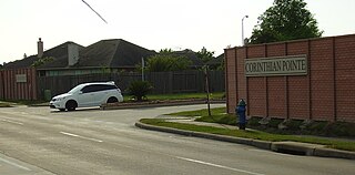
Corinthian Pointe is a large planned affordable subdivision located in Houston, Texas, in the United States. It is a part of the larger master planned community Pointe 2.3.4, and is within the 5 Corners District.
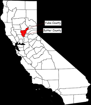
The Yuba–Sutter area, or Yuba City Metropolitan Statistical Area, is a smaller metropolitan community including Yuba and Sutter Counties in Northern California's Central Valley within the Greater Sacramento area.

The Newhall Land and Farming Company is a land management company based in Valencia, Santa Clarita, California, United States. The company is responsible for the master community planning of Valencia and previously developed other areas such as Canyon Country and Newhall which together with Saugus and Valencia would merge to create the city of Santa Clarita in 1987. The company is also responsible for the management of farm land elsewhere in the state.
Anaheim Hills is a planned community encompassing the eastern portions of the city of Anaheim, in Orange County, California.

The Treasure Island Development is a 405-acre (164 ha) major redevelopment project under construction on Treasure Island and parts of Yerba Buena Island in San Francisco Bay between San Francisco and Oakland, within San Francisco city limits. The Treasure Island Development Authority (TIDA) is a nonprofit organization formed to oversee the economic development of the former naval station. Treasure Island's development was set to break ground during mid-2012. However, on April 12, 2013, The San Francisco Chronicle reported that the deal has collapsed, with the Chinese investors from China Development Bank and China Railway Construction Corporation withdrawing from the project. The Treasure Island Project is being developed by a joint venture between Lennar and Kenwood Investments. The development is expected to cost US$1.5 billion.
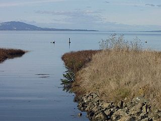
The Dotson Family Marsh, formerly Breuner Marsh, is a 238-acre regional park on San Pablo Bay in the East San Francisco Bay Area city of Richmond, California, In 2009 the East Bay Regional Parks District acquired the Breuner Marsh site, adding it to Point Pinole Regional Shoreline. A habitat restoration plan for 60 acres of wetlands and 90 acres of California coastal prairie was subsequently approved.
Tejon Mountain Village is a proposed residential, commercial, and recreational development of pristine, rugged property in the Tehachapi Mountains owned by the Tejon Ranch Company in Lebec, southern Kern County, California. The development includes the largest conservation and land-use agreement in California history. It was approved by the county's Board of Supervisors in October 2009. Opponents launched a legal challenge that was denied in state district court in April 2012.
Valencia is an unincorporated community in northwestern Los Angeles County, California, United States. The area, with major commercial and industrial parks, straddles State Route 126 and the Santa Clara River.
The Brisbane Baylands is a 660-acre (270 ha) parcel of land in Brisbane, just south of the San Francisco border. There have been several proposals to develop the site, which was previously used as a railyard and a municipal landfill; historical uses have led to contaminated soil, polluted stormwater runoff, and potential buried toxic waste. None of the present proposals have been approved by Brisbane's city council.

Ocean Pointe is a housing development and a census-designated place (CDP) located in the ʻEwa District and the City & County of Honolulu on the leeward side of Oʻahu in Hawaiʻi about fifteen miles (24 km) from Honolulu. As of the 2010 Census, the CDP had a total population of 8,361. This general area was previously known just as ʻEwa. In the late 19th century to early 20th century, ʻEwa was one of the large population centers on the Island of Oʻahu, with industry focused around sugar cane production. The ʻEwa Mill was a major employer that set up residential villages. Sugar cane is no longer grown on the ʻEwa Plain and Ocean Pointe is now part of Oʻahu's new suburban growth center—an area of substantial sprawl spreading unbroken to the south to ʻEwa Beach, north to Honouliuli, and west to Kalaeloa and Kapolei. This area is now referred to as Oʻahu's Second City, with a city center (downtown) located in Kapolei.
Warm Springs/South Fremont station is a Bay Area Rapid Transit (BART) station located in the Warm Springs district of Fremont, California. The station is served by the Orange Line and Green Line. It was the southern terminus of both lines from its opening on March 25, 2017 until June 13, 2020, when Milpitas and Berryessa/North San José stations opened as part of the Silicon Valley BART extension.
Ontario Ranch is a master-planned community located in the southern portion of the city of Ontario, California. It is the largest master-planned community in Southern California. The community is located south of E. Riverside Drive, between Euclid Avenue and Milliken Avenue, 2 miles west of Interstate 15 and south of State Route 60.
The Big Sur Land Trust is a private 501(c)(3) non-profit located in Monterey, California, that has played an instrumental role in preserving land in California's Big Sur and Central Coast regions. The trust was the first to conceive of and use the "conservation buyer" method in 1989 by partnering with government and developers to offer tax benefits as an inducement to sell land at below-market rates. Since 1978, with the support of donors, funders and partners, it has conserved over 40,000 acres through conservation easements, acquisition and transfer of land to state, county and city agencies. It has placed conservation easements on 7,000 acres and has retained ownership of over 4,000 acres.

Tuscany Village is a golf course community located in Henderson, Nevada. It was originally proposed by developer Jim Rhodes in 1995, under the name Palm City. The project was proposed for the former site of the Stewart gravel pit. The surrounding area initially sparked concern about the location's suitability, due to various environmental issues at the time. The site was located near sewage ponds and a longtime manufacturer of chemicals which had contaminated the land. Groundwater was also found to have high radioactive levels.
References
- ↑ "Sutter Pointe Specific Plan". Sutter County, California.
- ↑ Lamb, Celia (June 8, 2007). "Sutter landowner suit dropped by Lennar". American City Business Journals .
- ↑ Yune, Howard (July 1, 2009). "Board OKs Sutter Pointe plan". Appeal-Democrat .
- ↑ Abbott, Jake (November 18, 2020). "Sutter Pointe phase one approved". Appeal-Democrat .
- ↑ van der Meer, Ben (March 21, 2016). "Massive Sutter County home development moving closer to reality". American City Business Journals .
| | This Sutter County, California-related article is a stub. You can help Wikipedia by expanding it. |