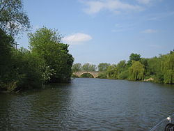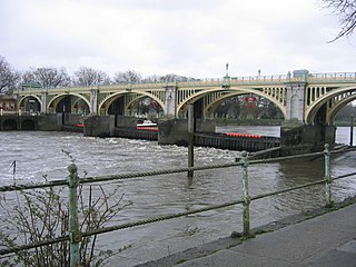
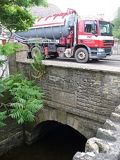
Richmond Lock and Footbridge is a lock, rising and falling low-tide barrage integrating controlled sluices and pair of pedestrian bridges on the River Thames in south west London, England and is a Grade II* listed structure. It is the furthest downstream of the forty-five Thames locks and the only one owned and operated by the Port of London Authority. It was opened in 1894 and is north-west of the centre of Richmond in a semi-urban part of south-west London. Downstream are Syon Park and Kew Gardens on opposite banks. It connects the promenade at Richmond with the neighbouring district of St. Margarets on the west bank during the day and is closed at night to pedestrians – after 19:30 GMT or after 21:30 when BST is in use. At high tide the sluice gates are raised and partly hidden behind metal arches forming twin footbridges.

Culham is a village and civil parish in a bend of the River Thames, 1 mile (1.6 km) south of Abingdon in Oxfordshire. The parish includes Culham Science Centre and Europa School UK. The parish is bounded by the Thames to the north, west and south, and by present and former field boundaries to the east. It is low-lying and fairly flat, rising from the Thames floodplain in the south to a north-facing escarpment in the north up to 260 feet (80 m) above sea level. The 2011 Census recorded its population as 453.

The Thames Path is a National Trail following the River Thames from its source near Kemble in Gloucestershire to the Woolwich foot tunnel, south east London. It is about 185 miles (298 km) long. A path was first proposed in 1948 but it only opened in 1996.

Chertsey Bridge is a road bridge across the River Thames in England, connecting Chertsey to low-lying riverside meadows in Laleham, Surrey. It is 550 yards (500 m) downstream from the M3 motorway bridge over the Thames and is close to Chertsey Lock on the reach above Shepperton Lock. The bridge is a seven-arch tied arch white stone bridge built 1783–85 and is a Grade II* listed building. It has a weight restriction of 18 tonnes for LGVs.

Godstow Bridge is a road bridge across the River Thames in England at Godstow near Oxford. The bridge is just upstream of Godstow Lock on the reach to King's Lock and carries a minor road between Wolvercote and Wytham.
Clifton Lock is a lock on River Thames in Oxfordshire, England. It is located south of the village of Clifton Hampden and north of Long Wittenham. It is at the start of the Clifton Cut, which bypasses the river to the north of Long Wittenham. The lock was completed in 1822 by the Thames Navigation Commissioners.

Benson Lock is a lock on the River Thames in England, close to Benson, Oxfordshire but on the opposite bank of the river. The first pound lock here was built by the Thames Navigation Commission in 1788 and it was replaced by the present masonry lock in 1870. The distance between Benson Lock and Cleeve Lock downstream is 6.5 miles (10.4 km) - the longest distance between locks on the River Thames.

Staines Bridge is a road bridge running in a south-west to north-east direction across the River Thames in Surrey. It is on the modern A308 road and links the boroughs of Spelthorne and Runnymede at Staines-upon-Thames and Egham Hythe. The bridge is Grade II listed.
Runnymede Bridge is a motorway, A-road, pedestrian, and cycle bridge, built in the 1960s and 1980s and expanded in the 2000s, carrying the M25 and A30 across the River Thames near the uppermost end of the Staines upon Thames and Egham reach of the river. It is oriented north–south and is southwest of Heathrow Airport. It consists of Runnymede Bridge and New Runnymede Bridge; commonly referred to as one bridge.

Culham Lock is a lock on the River Thames in England close to Culham, Oxfordshire. It is on a lock cut to the north of the main stream, which approaches the large village of Sutton Courtenay. The lock was built of stone by the Thames Navigation Commission in 1809.

Radcot Lock is a lock on the River Thames in England just downstream of Radcot, Oxfordshire, on the southern bank.

St John's Bridge is a two-section road bridge across the channel of the upper Thames near Lechlade, England, then across the lock cut to the south, the highest lock on the Thames. It is a Grade II listed building.

Tadpole Bridge is a road bridge across the River Thames in Oxfordshire, England, carrying a road between Bampton to the north and Buckland to the south. It crosses the Thames on the reach above Shifford Lock. It is a Grade II listed building. The bridge dates from the late 18th century, the earliest reference to it being in 1784. It is built of stone, and consists of one large arch. There is a public house near Tadpole Bridge called The Trout. Thacker noted that at one time the legend over the door read "The Trout, kept by A. Herring". The Trout is now a hotel and gastropub. The Thames Path crosses Tadpole Bridge.

Appleford Railway Bridge carries the Cherwell Valley Line from Didcot to Oxford across the River Thames near the village of Appleford-on-Thames, Oxfordshire, England. It crosses the Thames on the reach between Clifton Lock and Culham Lock.

Abingdon Bridge crosses the River Thames at the town of Abingdon, Oxfordshire, England. It carries the A415 road from Abingdon to Dorchester, Oxfordshire, over the reach of the Thames between Culham Lock and Abingdon Lock.

Sonning Backwater Bridges are the road bridges across the first two of three branches of the Thames at Sonning Eye, Oxfordshire, England.
Cricklade Town Bridge is a road bridge at Cricklade, Wiltshire, England across the River Thames. It is a Grade II listed building.
The Swift Ditch is a 2 km (1.2 mi) long artificial channel that formed a short-cut for river traffic to and from Oxford, across a meander of the River Thames in England. It was formerly the primary navigation channel. With the main river, it creates Andersey Island on the left bank of the Thames opposite Abingdon-on-Thames. Within a poem published in 1632, the Water Poet John Taylor wrote:
At Abingdon the shoals are worse and worse
That Swift Ditch seems to be the better course

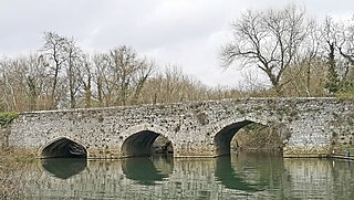
Culham Bridge is a medieval bridge crossing a present backwater of the River Thames in England at Culham, Oxfordshire, near the town of Abingdon. The bridge crosses Swift Ditch which was at one time the main navigation channel of the River Thames until Abingdon Lock was built in 1790. The bridge formerly carried the A415 road from Abingdon to Dorchester, Oxfordshire, but was superseded in 1928 by a modern road bridge.