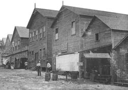
The story of the Sweeting family, English Bahamian settlers, is central to the Homestead's narrative. Their journey to Elliott Key came through Key West, a bustling maritime hub during the late 19th century. In April 1882, Asa Sweeting, along with his sons George and Thomas, embarked on a journey to Elliott Key, where they filed a homestead claim for 154.4 acres under the provisions of The Homestead Act of 1862.[3]
The Sweeting family's endeavors on Elliott Key primarily revolved around agriculture. They delved into pineapple, key lime, and tomato cultivation, capitalizing on the favorable, frost-free climate of the Florida Keys. Notably, George Sweeting, one of Asa's sons, owned and operated a fleet of schooners, facilitating the transport of their produce to northern markets.
The year 1906 marked a significant turning point for the Sweeting family when a devastating hurricane struck Elliott Key. The hurricane's storm surge inundated the island, causing extensive damage to homes and pineapple plantations. In response, the family shifted their focus to commercial fishing, which offered a stable year-round income source.[3] The challenges posed by the Great Depression prompted many families, including the Sweetings, to leave the island in search of better opportunities on the mainland.
Homestead is a city within Miami-Dade County in the U.S. state of Florida, between Biscayne National Park to the east and Everglades National Park to the west. Homestead is primarily a Miami suburb and a major agricultural area. It is a principal city of the Miami metropolitan area of South Florida, which was home to an estimated 6,012,331 people at the 2015 census. It is located approximately 26 miles (42 km) southwest of Miami, and 25 miles (40 km) northwest of Key Largo. The population was 80,737 as of the 2020 census.
Islandia is an unincorporated community and former city in Miami-Dade County, Florida, United States. It is located in the upper Florida Keys on the islands of Elliott Key and other nearby keys, such as Totten Key. It was the only municipality in the Florida Keys not located in neighboring Monroe County. The population was 18 at the 2010 Census. Most residents of the city were National Park Service employees.
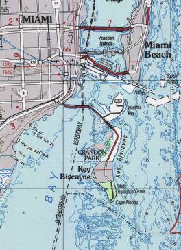
Biscayne National Park is an American national park located south of Miami, Florida in Miami-Dade County. The park preserves Biscayne Bay and its offshore barrier reefs. Ninety-five percent of the park is water, and the shore of the bay is the location of an extensive mangrove forest. The park covers 172,971 acres and includes Elliott Key, the park's largest island and northernmost of the true Florida Keys, formed from fossilized coral reef. The islands farther north in the park are transitional islands of coral and sand. The offshore portion of the park includes the northernmost region of the Florida Reef, one of the largest coral reefs in the world.
The Florida Keys are a coral cay archipelago off the southern coast of Florida, forming the southernmost part of the continental United States. They begin at the southeastern coast of the Florida peninsula, about 15 miles (24 km) south of Miami, and extend in a gentle arc south-southwest and then westward to Key West, the westernmost of the inhabited islands, and on to the uninhabited Dry Tortugas. The islands lie along the Florida Straits, dividing the Atlantic Ocean to the east from the Gulf of Mexico to the northwest, and defining one edge of Florida Bay. At the nearest point, the southern part of Key West is just 93 miles (150 km) from Cuba. The Keys are between about 24.3 and 25.5 degrees North latitude.
Biscayne Bay is a lagoon with characteristics of an estuary located on the Atlantic coast of South Florida. The northern end of the lagoon is surrounded by the densely developed heart of the Miami metropolitan area while the southern end is largely undeveloped with a large portion of the lagoon included in Biscayne National Park.
Key Biscayne is an island located in Miami-Dade County, Florida, located between the Atlantic Ocean and Biscayne Bay. It is the southernmost of the barrier islands along the Atlantic coast of Florida, and lies south of Miami Beach and southeast of Miami. The key is connected to Miami via the Rickenbacker Causeway, originally built in 1947.
Virginia Key is an 863-acre (3.49 km2) barrier island in Miami, Florida. It is located in Biscayne Bay south of Brickell and north of Key Biscayne and is accessible from the mainland via the Rickenbacker Causeway.
Indian Key Historic State Park is an island within the Florida State Park system, located just a few hundred yards southeast of U.S. 1 within the Florida Keys. The island was home to the town of Indian Key, Florida in the middle of the 19th century but is now an uninhabited ghost town. It is frequently visited by tourists and is the subject of an archaeological project to uncover the historic building foundations.
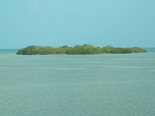
Elliott Key is the northernmost of the true Florida Keys, and the largest key north of Key Largo. It is located entirely within Biscayne National Park, in Miami-Dade County, Florida, east of Homestead, Florida. It is bordered by the Atlantic Ocean to the east, Biscayne Bay to the west, Sands Key to the north, and Old Rhodes Key to the south. Adams Key is just west of the southern end of Elliott Key. Elliott Key is about seven miles (11 km) long. Its maximum width is about 2,500 feet (760 m) near the north end, and its average width is less than 2,000 feet (610 m). The higher elevations on the island range from 6 to 8 feet above sea level and occur generally along an unimproved road that runs longitudinally through the center of the island. The average elevation is about 3 feet (0.91 m) above sea level. The key is accessible only by boat. Elliott Key has a National Park Service campground, but is otherwise uninhabited.
The Cape Florida Light is a lighthouse on Cape Florida at the south end of Key Biscayne in Miami-Dade County, Florida. Constructed in 1825, it guided mariners off the Florida Reef, which starts near Key Biscayne and extends southward a few miles offshore of the Florida Keys. It was operated by staff, with interruptions, until 1878, when it was replaced by the Fowey Rocks lighthouse. The lighthouse was put back into use in 1978 by the U.S. Coast Guard to mark the Florida Channel, the deepest natural channel into Biscayne Bay. They decommissioned it in 1990.
Fowey Rocks Light is located seven miles southeast of Cape Florida on Key Biscayne. The lighthouse was completed in 1878, replacing the Cape Florida Light. It was automated on May 7, 1975, and as of 2021 is still in operation. The structure is cast iron, with a screw-pile foundation, a platform and a skeletal tower. The light is 110 feet above the water. The tower framework is painted brown, while the dwelling and enclosed circular stair to the lantern is painted white. The original lens was a first-order drum Fresnel lens which stood about 12 feet (4 m) high and weighed about a ton (tonne). The light has a nominal range of 15 miles in the white sectors, and 10 miles in the red sectors.
Thousands of years before Europeans arrived, a large portion of south east Florida, including the area where Miami, Florida exists today, was inhabited by Tequestas. The Tequesta Native American tribe, at the time of first European contact, occupied an area along the southeastern Atlantic coast of Florida. They had infrequent contact with Europeans and had largely migrated by the middle of the 18th century. Miami is named after the Mayaimi, a Native American tribe that lived around Lake Okeechobee until the 17th or 18th century.
Arch Creek was an early settlement in Miami-Dade County, Florida, in present-day metropolitan Miami. Tequesta Indians thrived here before the first Europeans arrived in the early 16th century. The name is derived from the 40 feet (12 m) long natural limestone bridge that spanned the creek until 1973. It is part of the Arch Creek Memorial Park at 1855 Northeast 135th Street, on Biscayne Boulevard. It was added to the U.S. National Register of Historic Places on July 15, 1986.
The Barnacle Historic State Park is a 5-acre (2.0 ha) Florida State Park in the Coconut Grove neighborhood of Miami, Florida at 3485 Main Highway.
The Boca Chita Key Historic District is a U.S. historic district within the Biscayne National Park in Miami-Dade County, Homestead, Florida. Located on the northwest section of Boca Chita Key, delimited by Biscayne Bay in the north and west and a half ruined stone wall on its southern side, it contains three historic buildings and the Boca Chita Lighthouse. On 1 August 1997, it was listed in the National Register of Historic Places for its architectural, historical and recreational values.
Crandon Park is an 808-acre (3.27 km2) urban park in metropolitan Miami, occupying the northern part of Key Biscayne. It is connected to mainland Miami via the Rickenbacker Causeway.
Adams Key is an island at the northern part of the upper Florida Keys in Biscayne National Park. It is in Miami-Dade County, Florida. It is located west of the southern tip of Elliott Key, on the north side of Caesar Creek in the lower part of Biscayne Bay. The key is only accessible by boat, and overnight docking is prohibited.
The Ernest Hemingway House was the residence of American writer Ernest Hemingway in the 1930s. The house is situated on the island of Key West, Florida. It is at 907 Whitehead Street, across from the Key West Lighthouse, close to the southern coast of the island. Due to its association with Hemingway, the property is the most popular tourist attraction in Key West. It is also famous for its large population of so-called Hemingway cats, many of which are polydactyl.
The Trapp Homestead is a historic home in the Coconut Grove section of the City of Miami, Florida, United States. It is located at 2521 South Bayshore Drive. On November 10, 1994, it was added to the U.S. National Register of Historic Places. The home was constructed in 1887 out of oolitic lime quarried locally by Caleb Trapp and his son, Harlan. During construction, the Trapps lived on a thatched hut at the front of the property. The property is believed to be the oldest-standing masonry home in Miami-Dade County, Florida. The estate's construction pre-dates the incorporation of the City of Miami. The estate was particularly notable at the time because it was one of the few stone structures in Miami-Dade County, as nearly all structures in the area were built of wood at that time.
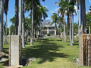
The Cocolobo Cay Club, later known as the Coco Lobo Club, was a private club on Adams Key in what is now Biscayne National Park, Florida. It was notable as a destination for the rich and the politically well-connected. Four presidents visited while president, and numerous U.S. senators including John F. Kennedy visited the club. It was established by millionaire Carl G. Fisher as a getaway in 1922, passing to motor boat racer Gar Wood, then to Nixon friend Bebe Rebozo in 1954. The main club building burned down in 1974 after the property was incorporated into Biscayne National Monument, and the remaining structures were destroyed by Hurricane Andrew in 1992.
This page is based on this Wikipedia article Text is available under the CC BY-SA 4.0 license; additional terms may apply. Images, videos and audio are available under their respective licenses.