
Rockingham County is a county located in the U.S. state of Virginia. As of the 2020 census, the population was 83,757. Its county seat is the independent city of Harrisonburg.

The Shenandoah Valley is a geographic valley and cultural region of western Virginia and the Eastern Panhandle of West Virginia in the United States. The Valley is bounded to the east by the Blue Ridge Mountains, to the west by the eastern front of the Ridge-and-Valley Appalachians, to the north by the Potomac River, to the south by the James River, and to the Southwest by the New River Valley. The cultural region covers a larger area that includes all of the Valley plus the Virginia Highlands to the west and the Roanoke Valley to the south. It is physiographically located within the Ridge and Valley Province and is a portion of the Great Appalachian Valley.

The Great Appalachian Valley, also called The Great Valley or Great Valley Region, is one of the major landform features of eastern North America. It is a gigantic trough, including a chain of valley lowlands, and the central feature of the Appalachian Mountains system. The trough stretches about 1,200 miles (1,900 km) from Quebec in the north to Alabama in the south and has been an important north–south route of travel since prehistoric times.
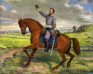
Jackson's Valley campaign, also known as the Shenandoah Valley campaign of 1862, was Confederate Maj. Gen. Thomas J. "Stonewall" Jackson's spring 1862 campaign through the Shenandoah Valley in Virginia during the American Civil War. Employing audacity and rapid, unpredictable movements on interior lines, Jackson's 17,000 men marched 646 miles (1,040 km) in 48 days and won several minor battles as they successfully engaged three Union armies, preventing them from reinforcing the Union offensive against Richmond.
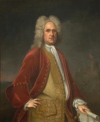
Alexander Spotswood was a British Army officer, explorer and lieutenant governor of Colonial Virginia; he is regarded as one of the most significant historical figures in British North American colonial history.

The Rappahannock River is a river in eastern Virginia, in the United States, approximately 195 miles (314 km) in length. It traverses the entire northern part of the state, from the Blue Ridge Mountains in the west where it rises, across the Piedmont to the Fall Line, and onward through the coastal plain to flow into the Chesapeake Bay, south of the Potomac River.

Skyline Drive is a 105-mile (169 km) National Parkway that runs the entire length of the National Park Service's Shenandoah National Park in the Blue Ridge Mountains of Virginia, generally along the ridge of the mountains. The drive's northern terminus is at an intersection with U.S. Route 340 (US 340) near Front Royal, and the southern terminus is at an interchange with US 250 near Interstate 64 (I-64) in Rockfish Gap, where the road continues south as the Blue Ridge Parkway. The road has intermediate interchanges with US 211 in Thornton Gap and US 33 in Swift Run Gap. Skyline Drive is part of Virginia State Route 48, which also includes the Virginia portion of the Blue Ridge Parkway, but this designation is not signed.

The Blue Ridge Railroad was incorporated by the Commonwealth of Virginia in March 1849 to provide a state-financed crossing of the Blue Ridge Mountains for the Virginia Central Railroad, which it became a part of after completion.

The Valley campaigns of 1864 began as operations initiated by Union Lieutenant General Ulysses S. Grant and resulting battles that took place in the Shenandoah Valley of Virginia during the American Civil War from May to October 1864. Some military historians divide this period into three separate campaigns. This article considers them together, as the campaigns interacted and built upon one another.

Rockfish Gap is a wind gap located in the Blue Ridge Mountains between Charlottesville and Waynesboro, Virginia, United States, through Afton Mountain, which is frequently used to refer to the gap.

Foot cavalry was an oxymoron coined by the media to describe the rapid movements of infantry troops serving under Confederate General Thomas Jonathan "Stonewall" Jackson during the American Civil War. Jackson's men marched on foot but they were able to cover long distances day after day to surprise the enemy.

The Knights of the Golden Horseshoe Expedition, also known as the Transmontane Expedition, took place in 1716 in the British Colony of Virginia. The Royal Governor and a number of prominent citizens traveled westward, across the Blue Ridge Mountains on an exploratory expedition. It is a frequently recounted event of the History of Virginia.
Thornton Gap is a wind gap located in the Blue Ridge Mountains in Virginia separating the Shenandoah Valley from the Piedmont region of the state.

Valley Pike or Valley Turnpike is the traditional name given for the Indian trail and roadway which is now approximated by U.S. Route 11 in the Shenandoah Valley of Virginia.

Covington and Ohio Railroad was part of a planned railroad link between Eastern Virginia and the Ohio River in the 1850s. The mountainous region of the Allegheny Front of the Appalachian Plateau between an existing canal, railroads and navigable rivers represented a formidable obstacle.

Ashby Gap, more commonly known as Ashby's Gap is a wind gap in the Blue Ridge Mountains on the border of Clarke County, Loudoun County and Fauquier County in Virginia. The gap is traversed by U.S. Route 50. The Appalachian trail also passes across the gap.

U.S. Route 50 is a transcontinental highway which stretches from Ocean City, Maryland to West Sacramento, California. In the U.S. state of Virginia, US 50 extends 86 miles (138 km) from the border with Washington, D.C. at a Potomac River crossing at Rosslyn in Arlington County to the West Virginia state line near Gore in Frederick County.

U.S. Route 33 is a part of the U.S. Highway System that runs from Elkhart, Indiana to Richmond, Virginia. In Virginia, the U.S. Highway runs 135.60 miles (218.23 km) from the West Virginia state line near Rawley Springs east to its eastern terminus at SR 33 in Richmond. US 33 is the primary east–west highway of Rockingham County, which lies in the Shenandoah Valley. The highway connects the independent city of Harrisonburg, the town of Elkton, and an entrance to Shenandoah National Park. East of the Blue Ridge Mountains, US 33 connects the Piedmont communities of Stanardsville, Gordonsville, and Louisa. The U.S. Highway is a major suburban and urban route in the Richmond metropolitan area. Within Richmond, US 33 runs concurrently with US 250. SR 33 continues from US 33's eastern terminus as a state-numbered extension of the U.S. Highway that connects Richmond with Virginia's Middle Peninsula.
The Romney Expedition was a military expedition of the Confederate States Army during the early part of the American Civil War. It is named for Romney, West Virginia, which at the time was still in the state of Virginia. The expedition was conducted in this locale from January 1 to January 24, 1862, as part of the preliminary actions of Stonewall Jackson's Valley Campaign. Confederate forces under Major General Thomas J. "Stonewall" Jackson cleared Union forces under Major General Nathaniel Banks and Brigadier General William S. Rosecrans from the lower Shenandoah Valley and surrounding Allegheny ranges, and then successfully severed the Baltimore and Ohio Railroad and the Chesapeake and Ohio Canal.
The Manassas Gap Railroad (MGRR) ran from Mount Jackson, Virginia, to the Orange and Alexandria Railroad's Manassas Junction, which later became the city of Manassas, Virginia. Chartered by the Virginia General Assembly in 1850, the MGRR was a 4 ft 8 in narrow gauge line whose 90 completed miles of track included 38 miles (61 km) of 60 pounds-per-yard T-rail and 52 miles (84 km) of 52 pounds-per-yard T-rail. A total of nine locomotives and 232 cars were operated on the line, serving 20 stations.