
Ouse Washes is a linear 2,513.6-hectare (6,211-acre) biological Site of Special Scientific Interest stretching from near St Ives in Cambridgeshire to Downham Market in Norfolk. It is also a Ramsar internationally important wetland site, a Special Protection Area for birds, a Special Area of Conservation and a Nature Conservation Review site, Grade I. An area of 186 hectares between March and Ely is managed by the Wildlife Trust for Bedfordshire, Cambridgeshire and Northamptonshire and another area near Chatteris is managed by the Royal Society for the Protection of Birds. The Wildfowl & Wetlands Trust manages another area near Welney.
The Gloucestershire Wildlife Trust is the Gloucestershire local partner in a conservation network of 46 Wildlife Trusts. The Wildlife Trusts are local charities with the specific aim of protecting the United Kingdom's natural heritage. The Gloucestershire Wildlife Trust is managed by a board of trustees elected from its membership who provide overall direction for the development of the trust and there are advisory committees. The work of the trust is carried out through staff and volunteers.

The Cotswold Water Park is the United Kingdom's largest marl lake system, straddling the Wiltshire–Gloucestershire border, north-west of Cricklade and south of Cirencester. There are 180 lakes, spread over 42 square miles (110 km2).
Brownsover is a residential and commercial area of Rugby, Warwickshire in England, about 1+1⁄2 miles north of the town centre. The area is named after the original hamlet of Brownsover. Since 1960, the area has been subsumed by the expansion of Rugby, with the construction of a number of housing estates, industrial estates and retail parks.

Loynton Moss is a nature reserve of the Staffordshire Wildlife Trust, near the village of Woodseaves, in Staffordshire, England. It is adjacent to the Shropshire Union Canal, as it runs from nearby Norbury to High Offley.

RSPB Dearne Valley Old Moor is an 89-hectare (220-acre) wetlands nature reserve in the Dearne Valley near Barnsley, South Yorkshire, run by the Royal Society for the Protection of Birds (RSPB). It lies on the junction of the A633 and A6195 roads and is bordered by the Trans Pennine Trail long-distance path. Following the end of coal mining locally, the Dearne Valley had become a derelict post-industrial area, and the removal of soil to cover an adjacent polluted site enabled the creation of the wetlands at Old Moor.

Coombe Hill Canal lies in the Vale of Gloucester, south west England, north of Leigh and runs west 2.75 miles (4.43 km) from Coombe Hill Basin to the River Severn near Wainlode Hill. It opened in 1796 and closed 80 years later in 1876, after the only lock was damaged by flooding. The Gloucestershire Wildlife Trust purchased the Coombe Hill Canal nature reserve in 1985 and the area is managed by the trust. Adjacent to the Coombe Hill Canal is a large area of wet meadowland situated midway between Gloucester and Tewkesbury to the west of the A38, which was purchased by the trust in 1999. There is a north and a south meadow. This land and the canal itself often flood in winter, which attracts hundreds of wildfowl.
Whitacre Heath is a small village in the North Warwickshire district of the county of Warwickshire in England. It is one of 'The Whitacres' - Whitacre Heath, Nether Whitacre and Over Whitacre. Whitacre Heath is actually the heath of Nether Whitacre and not a separate parish. Whitacre Heath is newer and of 19th-century origin. It stems from the early days of railways in the 1830s, and from later developments by Joseph Chamberlain and the Water Department of the City of Birmingham. The Stonebridge Railway was opened on 12 August 1839 to provide a link between the Birmingham and Derby Junction Railway and the London and Birmingham Railway at Hampton in Arden, via Stonebridge. The line became redundant in the 1930s and the track bed is now a footpath for walkers. There are Victorian brick buildings for the management of drinking water, at Whitacre water works, which were originally associated with public works by the City of Birmingham. The village is now largely residential and agricultural.

Kingfisher Country Park is a country park situated in the Metropolitan Borough of Solihull in England, straddling the historic border of Warwickshire and Worcestershire, mostly within the former. Initially designated as Project Kingfisher by Birmingham City Council, the park was formally declared a country park in July 2004. The country park is located along an 11 km (6.8 mi) stretch of the River Cole from Small Heath in Birmingham to Chelmsley Wood at the M6 motorway. It is a Local Nature Reserve.
Ashford Green Corridor is a green space that runs through the town of Ashford in Kent, England. The Green Corridor is made up of parks, recreation grounds and other green spaces alongside the rivers that flow through Ashford. It is a Local Nature Reserve.

Brandon Marsh is a Site of Special Scientific Interest (SSSI) and nature reserve in Warwickshire, England. It is situated adjacent to the River Avon, near the village of Brandon, a few miles east of Coventry.

Alvecote Pools is a Site of Special Scientific Interest (SSSI) and nature reserve situated alongside the River Anker, adjacent to the hamlet of Alvecote on the border of Warwickshire and Staffordshire in England. The majority of the reserve lies in the former county. Consisting of two discrete areas, Pooley Fields and Alvecote Meadows, the site covers 128 ha in total and is the largest SSSI in Warwickshire. First notified in 1955, the site has been owned by the Warwickshire Wildlife Trust since 1997.

Sapperton Valley is a 3.7-hectare (9.1-acre) nature reserve near Chalford in the Stroud district of Gloucestershire, England. The site is managed by the Gloucestershire Wildlife Trust under leasing arrangements with the Bathurst Estate, in place since 1964.

The River Swift is a 14-mile (23 km) long tributary of the River Avon that rises in south Leicestershire, and flows through the town of Lutterworth before joining the Avon at its confluence at Rugby in Warwickshire in the English Midlands.
The Rodley Nature Reserve is a wetland reserve created in 1999 on the site of a former sewage works on the outskirts of Rodley, West Yorkshire, United Kingdom. It is situated just north of Town Street on the north bank of the River Aire.

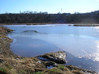
Newbold Quarry Park is a nature reserve in Newbold-on-Avon, around 1½ miles north-west of Rugby town centre, Warwickshire, England. It consists of a former water-filled quarry surrounded by woodlands and covers an area of 10.50 hectares. It is managed by the Warwickshire Wildlife Trust on behalf of Rugby Borough Council.

Irthlingborough Lakes and Meadows is a 117-hectare (290-acre) nature reserve in Northamptonshire, owned and managed by the Wildlife Trust for Bedfordshire, Cambridgeshire and Northamptonshire. The character of the reserve is defined by flooded gravel pits and wet grassland, providing an excellent habitat for large variety of wetland flora and fauna.

Papermill Reedbed is a 6 hectare nature reserve in Bramford in Suffolk. It is owned by Blakenham Farms and managed by the Suffolk Wildlife Trust.

The Midland Counties Railway viaduct is a disused railway viaduct at Rugby, Warwickshire, which crosses over both the A426 Rugby to Leicester road, and the River Avon to the north of Rugby town centre.

Clapton Moor is a 40-hectare (99-acre) Avon Wildlife Trust nature reserve and part of the Gordano Valley, Clapton Moor, Middle Bridge and rhynes Site of Nature Conservation Interest in Somerset, England.
