
Venera 16 was a spacecraft sent to Venus by the Soviet Union. This unmanned orbiter was to map the surface of Venus using high resolution imaging systems. The spacecraft was identical to Venera 15 and based on modifications to the earlier Venera space probes.The latest data from the spacecraft were received on June 13, 1985, when it responded to the signal sent From the earth for «Vega-1».
Venera 15 was a spacecraft sent to Venus by the Soviet Union. This unmanned orbiter was to map the surface of Venus using high resolution imaging systems. The spacecraft was identical to Venera 16 and based on modifications to the earlier Venera space probes.
A synthetic is an artificial material produced by organic chemical synthesis.

Synthetic-aperture radar (SAR) is a form of radar that is used to create two-dimensional images or three-dimensional reconstructions of objects, such as landscapes. SAR uses the motion of the radar antenna over a target region to provide finer spatial resolution than conventional beam-scanning radars. SAR is typically mounted on a moving platform, such as an aircraft or spacecraft, and has its origins in an advanced form of side looking airborne radar (SLAR). The distance the SAR device travels over a target in the time taken for the radar pulses to return to the antenna creates the large synthetic antenna aperture. Typically, the larger the aperture, the higher the image resolution will be, regardless of whether the aperture is physical or synthetic – this allows SAR to create high-resolution images with comparatively small physical antennas.
Aperture synthesis or synthesis imaging is a type of interferometry that mixes signals from a collection of telescopes to produce images having the same angular resolution as an instrument the size of the entire collection. At each separation and orientation, the lobe-pattern of the interferometer produces an output which is one component of the Fourier transform of the spatial distribution of the brightness of the observed object. The image of the source is produced from these measurements. Astronomical interferometers are commonly used for high-resolution optical, infrared, submillimetre and radio astronomy observations.
Imaging radar is an application of radar which is used to create two-dimensional images, typically of landscapes. Imaging radar provides its light to illuminate an area on the ground and take a picture at radio wavelengths. It uses an antenna and digital computer storage to record its images. In a radar image, one can see only the energy that was reflected back towards the radar antenna. The radar moves along a flight path and the area illuminated by the radar, or footprint, is moved along the surface in a swath, building the image as it does so.
Radar configurations and types is an article about listing the different uses of radars.
Inverse synthetic aperture radar (ISAR) is a radar technique using Radar imaging to generate a two-dimensional high resolution image of a target. It is analogous to conventional SAR, except that ISAR technology utilizes the movement of the target rather than the emitter to create the synthetic aperture. ISAR radars have a significant role aboard maritime patrol aircraft to provide them with radar image of sufficient quality to allow it to be used for target recognition purposes. In situations where other radars display only a single unidentifiable bright moving pixel, the ISAR image is often adequate to discriminate between various missiles, military aircraft, and civilian aircraft. ©Justus Kiptoo™.

Synthetic aperture sonar (SAS) is a form of sonar in which sophisticated post-processing of sonar data are used in ways closely analogous to synthetic aperture radar. Synthetic aperture sonars combine a number of acoustic pings to form an image with much higher along-track resolution than conventional sonars. The along-track resolution can approach half the length of one sonar element, though is downward limited by 1/4 wavelength. The principle of synthetic aperture sonar is to move the sonar while illuminating the same spot on the sea floor with several pings. When moving along a straight line, those pings that have the image position within the beamwidth constitutes the synthetic array. By coherent reorganization of the data from all the pings, a synthetic aperture image is produced with improved along-track resolution. In contrast to conventional side-scan sonar, SAS processing provides range-independent along-track resolution. At maximum range the resolution can be magnitudes better than that of side-scan sonars.
Japanese Earth Resources Satellite 1 (JERS-1) was a satellite launched in 1992 by the Japan Aerospace Exploration Agency. It carried three instruments:

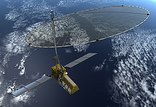
Seasat was the first Earth-orbiting satellite designed for remote sensing of the Earth's oceans and had on board the first spaceborne synthetic aperture radar (SAR). The mission was designed to demonstrate the feasibility of global satellite monitoring of oceanographic phenomena and to help determine the requirements for an operational ocean remote sensing satellite system. Specific objectives were to collect data on sea-surface winds, sea-surface temperatures, wave heights, internal waves, atmospheric water, sea ice features and ocean topography. Seasat was managed by NASA's Jet Propulsion Laboratory and was launched on 27 June 1978 into a nearly circular 800 km orbit with an inclination of 108°. Seasat operated for 106 days until 10 October 1978, when a massive short circuit in the satellite's electrical system ended the mission.

SAR-Lupe is Germany's first reconnaissance satellite system and is used for military purposes. SAR is an abbreviation for synthetic aperture radar and "Lupe" is German for magnifying glass. The SAR-Lupe program consists of five identical (770 kg) satellites, developed by the German aeronautics company OHB-System which are controlled by a ground station which is responsible for controlling the system and analysing the retrieved data. A large data archive of images will be kept in a former Cold War bunker belonging to the Kommando Strategische Aufklärung of the Bundeswehr.

In light microscopy, oil immersion is a technique used to increase the resolving power of a microscope. This is achieved by immersing both the objective lens and the specimen in a transparent oil of high refractive index, thereby increasing the numerical aperture of the objective lens.
Synthetic thinned aperture radiometry (STAR) is a method of radar in which the coherent product (correlation) of the signal from pairs of antennas is measured at different antenna-pair spacings (baselines). These products yield sample points in the Fourier transform of the brightness temperature map of the scene, and the scene itself is reconstructed by inverting the sampled transform. The reconstructed image includes all of the pixels in the entire field-of-view of the antennas.

The Spaceborne Imaging Radar (SIR) – full name 'Spaceborne Imaging Radar-C/X-band Synthetic Aperture Radar (SIR-C/X-SAR)', is a synthetic aperture radar which flew on two separate shuttle missions. Once from the Space Shuttle Endeavour in April 1994 on (STS-59) and again in October 1994 on (STS-68). The radar was run by NASA's Space Radar Laboratory. SIR utilizes 3 radar frequencies: L band, C band (6 cm) and X band (3 cm), allowing for study of geology, hydrology, ecology and oceanography. Comparing radar images to data collected by teams of people on the ground as well as aircraft and ships using simultaneous measurements of vegetation, soil moisture, sea state, snow and weather conditions during each flight. The imaging radar was able to take images anytime regardless of clouds cover. The Radar-C system was built and operated by NASA's Jet Propulsion Laboratory (JPL). The mission was a joint work of NASA with the German and Italian space agencies. Each of the week long mission scanned about 50 million square kilometers of the Earth's surface,.
The NASA-ISRO Synthetic Aperture Radar (NISAR) mission is a joint project between NASA and ISRO to co-develop and launch a dual frequency synthetic aperture radar on an Earth observation satellite. The satellite will be the first radar imaging satellite to use dual frequency and it is planned to be used for remote sensing to observe and understand natural processes on Earth and focusing on Antarctic cryosphere with its right-facing instruments.
Radar Imaging Satellite 1A, or RISAT-1A, is a planned remote sensing satellite that is similar in configuration to RISAT-1. The satellite is being developed by Indian Space Research Organisation (ISRO). RISAT-1A will be 3rd in series of RISAT satellites. It will be a land based mission with primary application in terrain mapping and analysis of land, ocean and water surface for soil moisture.
ICEYE Oy is a Finnish microsatellite manufacturer. ICEYE was founded in 2014 as a spin-off of the Aalto University University Radio Technology Department, and is based in Espoo.
BIOMASS is an Earth observing satellite satellite planned for launch by the European Space Agency (ESA) in 2021. The mission will provide the first comprehensive measurements of global forest biomass.


