Akeldama is the Aramaic name for a place in Jerusalem associated with Judas Iscariot, one of the original twelve apostles of Jesus.
The use of rock-cut cave tombs in the region began in the early Canaanite period, from 3100–2900 BCE. The custom lapsed a millennium, however, before re-emerging in the earliest Israelite tombs, dating to the 9th century BCE in Jerusalem. The use of rock-cut tombs reached its peak in the 8th and 7th centuries BCE, before rapidly declining and eventually falling out of use in the 6th century BCE in some regions. It reappeared during the Second Temple period and continued into the Late Roman and Byzantine periods.
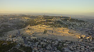
The Mount of Olives or Mount Olivet is a mountain ridge in East Jerusalem, east of and adjacent to Jerusalem's Old City. It is named for the olive groves that once covered its slopes. The southern part of the mount was the Silwan necropolis, attributed to the elite of the ancient Kingdom of Judah. The western slopes of the mount, those facing Jerusalem, have been used as a Jewish cemetery for over 3,000 years and holds approximately 150,000 graves, making it central in the tradition of Jewish cemeteries. Atop the hill lies the Palestinian neighbourhood of At-Tur, a former village that is now part of East Jerusalem.

An ossuary is a chest, box, building, well, or site made to serve as the final resting place of human skeletal remains. They are frequently used where burial space is scarce. A body is first buried in a temporary grave, then after some years the skeletal remains are removed and placed in an ossuary. The greatly reduced space taken up by an ossuary means that it is possible to store the remains of many more people in a single tomb than possible in coffins. The practice is sometimes known as grave recycling.

Mount Scopus is a mountain in northeast Jerusalem.

Mount Herzl, also Har ha-Zikaron, is the site of Israel's national cemetery and other memorial and educational facilities, found on the west side of Jerusalem beside the Jerusalem Forest.

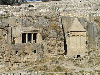
The Tomb of Absalom, also called Absalom's Pillar, is an ancient monumental rock-cut tomb with a conical roof located in the Kidron Valley in Jerusalem, a few metres from the Tomb of Zechariah and the Tomb of Benei Hezir. Although traditionally ascribed to Absalom, the rebellious son of King David of Israel, recent scholarship has dated it to the 1st century AD.
Kidron Valley is the modern name of the valley originating slightly northeast of the Old City of Jerusalem, which then separates the Temple Mount from the Mount of Olives, and ending at the Dead Sea. Beyond Jerusalem it continues in a general south-easterly direction through the Judean desert in the West Bank, reaching the Dead Sea near the settlement of Ovnat, and descending 4,000 feet (1,200 m) along its 20-mile (32 km) course.

Tourism in Israel is one of the country's major sources of income, with a record 4.55 million tourist arrivals in 2019. Tourism contributed NIS 20 billion to the Israeli economy in 2017, making it an all-time record. Israel offers a plethora of historical and religious sites, beach resorts, natural sites, archaeological tourism, heritage tourism, adventure tourism, and ecotourism. For practical reasons, this article also covers tourism in the Israeli-occupied West Bank and the occupied Golan Heights, since it is closely interconnected with the mass tourism in Israel. Over the millennia the Holy Land has been amongst the most visited lands in the world.

Ramat Eshkol is an Israeli settlement and neighborhood in northern East Jerusalem. It was built on land captured from Jordan in the Six-Day War and occupied by Israel since 1967, and was the first settlement built in East Jerusalem beyond the Green Line by Israel. The international community considers Israeli settlements in East Jerusalem illegal under international law, but the Israeli government disputes this. As of 2017, about 8,975 people live in the neighborhood.

Herbert Bentwich was a British Zionist leader and lawyer.
Kiryat Shmuel is a neighborhood in central West Jerusalem founded in 1926. It is named for Rabbi Shmuel Salant, the Ashkenazi Chief Rabbi of Jerusalem in 1878–1909. Kiryat Shmuel is located between Rehavia and Katamon.

Al-Issawiya is a Palestinian neighborhood in East Jerusalem. It is located on the eastern slopes of the Mount Scopus ridge. To the east and north, it is bordered by Road 1, which connects Jerusalem with the settlement of Ma’ale Adumim; immediately adjoining it to the north, west and southwest are the Hadassah Medical Center, the Hebrew University campus, the Jewish settlement of French Hill and the Ofarit military base; to the south, there is a planned park, the Mount Scopus slopes national park.

Shmuel HaNavi is a neighborhood in north-central Jerusalem. It is bordered by the Sanhedria Cemetery to the north, Maalot Dafna to the east, Arzei HaBira to the south, and the Bukharan Quarter to the west. It is named after Shmuel HaNavi Street, which runs along its western border and is the main road leading to the tomb of Samuel the prophet just outside Jerusalem's city limits.
Ir Ganim is a neighborhood in southwest Jerusalem, bordering Kiryat Menachem.

Jerusalem Walls National Park is an Israeli national park located near the walls of the Old City of Jerusalem. The national park was designed originally to surround the old city from all sides, to separate between the old city and the new constructions surrounding it while at the same time connecting between them, while preventing construction near the walls.

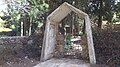
The Cave of Nicanor is an ancient burial cave located on Mount Scopus in Jerusalem. Among the ossuaries discovered in the cave is one with an inscription referring to "Nicanor the door maker". The cave is located in the National Botanic Garden of Israel on the grounds of the Mount Scopus campus of the Hebrew University of Jerusalem.

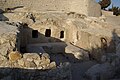
Tombs of the Sanhedrin, also Tombs of the Judges, is an underground complex of 63 rock-cut tombs located in a public park in the northern Jerusalem neighborhood of Sanhedria. Built in the 1st century CE, the tombs are noted for their elaborate design and symmetry. They have been a site for Jewish pilgrimage since the medieval period. The popular name of the complex, which has the most magnificently carved pediment of ancient Jerusalem, is due to the fact that the number of burial niches it contains is somewhat close to that of the members of the ancient Jewish supreme court, the Great Sanhedrin, namely 71.
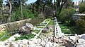
National Botanic Garden of Israel Hebrew: הגן הבוטני לצמחי ארץ ישראל ע"ש מונטג'יו למפורט), is a botanical garden located on the Mount Scopus campus of the Hebrew University of Jerusalem. Its herbarium and Institution Code is HUJ. It covers an area of 25 dunams and contains 950 varieties of plants, 40% of them wild.