Table Rock Indian Reservation

Last updated
"The Treaty for Sale of Lands", a news article published in the Oregon Statesman on September 27, 1853 News Article, The Treaty for Sale of Lands Oregon Statesman, September 27, 1853.jpg
"The Treaty for Sale of Lands", a news article published in the Oregon Statesman on September 27, 1853
Modern image of Lower Table Rock BLM picture of Lower Table Rock.jpg
Modern image of Lower Table Rock

Table Rock Reservation was a short-lived Indian reservation north of the Rogue River in Oregon, United States. It was established by treaty with the Rogue River Indians in 1853. Following the conclusion of the Rogue River Wars in 1856, the Native American inhabitants were moved to other reservations. [1] The reservation was in Southern Oregon, between Upper Table Rock and Evans Creek. [2]

Contents

History

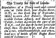
Conflicts between miners and Rogue River Indians began in the early 1850s, when gold was discovered in what is now Oregon. This conflict turned into open warfare and several treaties were signed in an attempt to end the hostilities resulting in the Native Americans ceding their land. They were moved to Table Rock Reservation before being moved to the Grand Ronde Reservation and the Coast Reservation (a small fraction of which is now the Siletz Reservation). [2] [3]

Native Americans lost most of the Bear Creek Valley in exchange for the Table Rock Reservation. In October 1855, a lack of food, a cold winter, and disease devastated the families on the reservation, so a group of Takelma Indians returned to their old village at the mouth of Little Butte Creek on the upper Rogue River. A volunteer militia then attacked them, killing 23 including women and children. A small group responded to this dire situation by fleeing to the Rogue River Canyon, attacking miners and settlers from Evans Creek to Galice Creek on the way. The militia and regular army troops caught up with them in the Grave Creek Hills, and the Indians inflicted heavy casualties on the poorly trained troops. What became known as the Battle of Hungry Hill was a major victory for the Indians. In November, the militia and army again attacked, and again were defeated. The attack was meant to be a surprise, but the Native Americans heard them chopping trees to build rafts and were prepared. [4]

Several more battles were then fought. In the spring of 1856, a force of nearly 200 volunteers arrived at the mouth of Ditch Creek on the Rogue River, and fired on the Indians' settlement on the far shore. Up to 30 Indians were killed during the day-long assault, forcing the survivors to surrender. In the summer and following winter, licensed hunters killed and captured Indians who remained in the area. [4]

In the winter of 1856–57, 400 Indians were marched from Table Rock 200 miles (320 km) north to the new Grand Ronde Reservation in Yamhill County. The survivors of the Battle of Hungry Hill were loaded onto a steamboat at Port Orford, Oregon then transported via the Columbia River and Willamette River and then overland to the Siletz Reservation near the Oregon Coast. [4]

See also

Related Research Articles

The Coquille are a Native American people who historically lived in the Coquille River watershed and nearby coast south of Coos Bay. They were signatories of the Oregon Coast Tribes Treaty of 1855 and were subsequently removed to the Siletz Reservation in northwestern Oregon in 1856. Most Coquille people today live there as members of the Confederated Tribes of Siletz Indians, but some whose ancestors remained in the traditional homeland or fled the reservation now make up the Coquille Indian Tribe, centered in southwest Oregon where the Coos River flows into Coos Bay.

<span class="mw-page-title-main">Umpqua people</span>

The Umpqua people are an umbrella group of several distinct tribal entities of Native Americans of the Umpqua Basin in present-day south central Oregon in the United States. The area south of Roseburg is now known as the Umpqua Valley.

The Tututni tribe is a historic Native American tribe, one of Lower Rogue River Athabascan tribes from southwestern Oregon who signed the 1855 Coast Treaty, and were removed to the Siletz Indian Reservation in Oregon. They traditionally lived along the Rogue River and its tributaries, near the Pacific Coast between the Coquille River on the north and Chetco River in the south. Lower Rogue River Athabascan tribes are a group of Athabascan tribes who were historically located in southwestern Oregon in the United States and speak the same Athabascan language, known as Lower Rogue River.

The Siletz were the southernmost of several divisions of the Tillamook people speaking a distinct dialect; the other dialect-divisions were: Salmon River on the Salmon River, Nestucca on Little Nestucca River, Nestucca River and Nestucca Bay, Tillamook Bay on the Tillamook Bay and the mouths of the Kilchis, Wilson, Trask and Tillamook rivers, and Nehalem on Nehalem River. The name "Siletz" comes from the name of the Siletz River on which they live. The origin of the name is unknown

<span class="mw-page-title-main">Kalapuya</span> Native American tribe, native of the Willamette Valley, modern-day Oregon

The Kalapuya are a Native American people, which had eight independent groups speaking three mutually intelligible dialects. The Kalapuya tribes' traditional homelands were the Willamette Valley of present-day western Oregon in the United States, an area bounded by the Cascade Range to the east, the Oregon Coast Range at the west, the Columbia River at the north, to the Calapooya Mountains of the Umpqua River at the south.

<span class="mw-page-title-main">Takelma</span>

The Takelma are a Native American people who originally lived in the Rogue Valley of interior southwestern Oregon.

The Molala are a people of the Plateau culture area in the Oregon Cascades and central Oregon, United States. They are one of the Confederated Tribes of the Grand Ronde Community of Oregon, with 141 of the 882 members in the 1950s claiming Molala descent. The Confederated Tribes of Siletz Indians also has Molalla representation among its confederation of Tribes and Bands. The Siletz Reservation was established in 1855, for the Coast, Willamette and Umpqua Tribes. The Molalla are one of the Tribes who signed the 1855 Willamette Valley Treaty.

The Shastan peoples are a group of linguistically related indigenous peoples from the Klamath Mountains. They traditionally inhabited portions of several regional waterways including the Klamath, Salmon, Sacramento and McCloud rivers. Shastan lands presently form portions of the Siskiyou, Klamath and Jackson counties. Scholars have generally divided the Shastan peoples into four languages, although arguments in favor of more or less existing have been made. Speakers of Shasta proper-Kahosadi, Konomihu, Okwanuchu, and Tlohomtah’hello "New River" Shasta resided in settlements typically near a water source. Their villages often had only either one or two families. Larger villages had more families and additional buildings utilised by the community.

<span class="mw-page-title-main">Confederated Tribes of the Grand Ronde Community of Oregon</span> Indian tribes in Oregon, United States

The Confederated Tribes of the Grand Ronde Community of Oregon (CTGR) consists of twenty-seven Native American tribes with long historical ties to present-day western Oregon between the western boundary of the Oregon Coast and the eastern boundary of the Cascade Range, and the northern boundary of southwestern Washington and the southern boundary of northern California. The community has an 11,288-acre (45.7 km2) Indian reservation, the Grand Ronde Indian Reservation, which was established in 1855 in Yamhill and Polk counties.

<span class="mw-page-title-main">Rogue River Wars</span> 1855-56 conflict between Native American tribes and U.S. soldiers and settlers in Oregon

The Rogue River Wars were an armed conflict in 1855–1856 between the U.S. Army, local militias and volunteers, and the Native American tribes commonly grouped under the designation of Rogue River Indians, in the Rogue River Valley area of what today is southern Oregon. The conflict designation usually includes only the hostilities that took place during 1855–1856, but there had been numerous previous skirmishes, as early as the 1830s, between European American settlers and the Native Americans, over territory and resources.

The Confederated Tribes of Siletz Indians in the United States is a federally recognized confederation of more than 27 Native American tribes and bands who once inhabited an extensive homeland of more than 20 million acres from northern California to southwest Washington and between the summit of the Cascades and the Pacific Ocean. After the Rogue River Wars, these tribes were removed to the Coast Indian Reservation, now known as the Siletz Reservation. The tribes spoke at least 11 distinct languages, including Tillamook, Shasta, Lower Chinook, Kalapuya, Takelma, Alsea-Yaquina, Siuslaw/Lower Umpqua, Coos, the Plateau Penutian languages Molala and Klickitat, and several related Oregon Athabaskan languages.

The Shasta Costa, are a Native American tribe, one of Lower Rogue River Athabascan tribes from southwestern Oregon, who originally lived on the Rogue River and its tributaries, or, more precisely, on the "Lower Illinois River and the Rogue River between present-day Agness and Foster Bar." They spoke Shasta Costa dialect of Tututni language. They were classified as Rogue River Indians for the purposes of treaty negotiation. One of their villages, Tlegetlinten, was located near Agness, and was eventually "occupied by Euro-American settlers."

Latgawa are Native American people who lived in the Rogue Valley of interior southwest Oregon. In their own language "Latgawa" /latʰka:wàʔ/ means "those living in the uplands," though they were also known as the Walumskni by the neighboring Klamath tribe.

<span class="mw-page-title-main">Rogue River Indians</span>

Rogue River Indians are a conglomeration of many tribal groups in the Rogue River Valley area, belonging to three language families: Athabascan, Takelma, and Shastan.

The Oregon Superintendent of Indian Affairs was an official position of the U.S. state of Oregon, and previously of the Oregon Territory, that existed from 1848 to 1873.

<span class="mw-page-title-main">Upper and Lower Table Rock</span> Two prominent volcanic plateaus located north of the Rogue River in Jackson County, Oregon, US

Upper Table Rock and Lower Table Rock are two prominent volcanic plateaus located just north of the Rogue River in Jackson County, Oregon, U.S. Created by an andesitic lava flow approximately seven million years ago and shaped by erosion, they now stand about 800 feet (240 m) above the surrounding Rogue Valley. The Table Rocks are jointly owned; The Nature Conservancy is responsible for 3,591 acres (1,453 ha), while the Bureau of Land Management is responsible for 1,280 acres (520 ha).

<span class="mw-page-title-main">Cow Creek Band of Umpqua Tribe of Indians</span> Indian tribe in Oregon, United States

The Cow Creek Band of Umpqua Tribe of Indians, known to the Bureau of Indian Affairs (BIA) as the Cow Creek Band of Umpqua Indians of Oregon is a federally recognized Native American tribal government based in Roseburg, Oregon, United States. The tribe takes its name from Cow Creek, a tributary of the South Umpqua River.

Tolo is an unincorporated community in Jackson County, Oregon, United States, located north of Interstate 5, between Central Point and Gold Hill, south of Sams Valley. Platted near the site of the Willow Springs mining camp, the town was envisioned to be one of the biggest cities of Southern Oregon. Tolo was platted in 1888, but was virtually abandoned by the year 1918. In 1986, the Jackson County Commission returned the plat to public ownership.

<span class="mw-page-title-main">Native American peoples of Oregon</span> Indigenous people of the area now known as Oregon

The Native American peoples of Oregon are the set of Indigenous peoples who have inhabited or who still inhabit the area delineated in today's state of Oregon in the Pacific Northwest region of the United States. While the state of Oregon currently maintains relations with nine federally recognized tribal groups, the state was previously home to a much larger number of autonomous tribal groups, which today either no longer exist or have been absorbed into these larger confederated entities. Six of the nine tribes gained federal recognition in the late 20th century, after undergoing the termination and restoration of their treaty rights starting in the 1950s.

<span class="mw-page-title-main">Tecumtum</span> American Indian chief (died 1864)

Chief Tecumtum, was the chief of the Etch-ka-taw-wah band of Athabaskan Indians and a leader in the Rogue River Wars. He signed three treaties with the United States between 1851 and 1854.

References

  1. "Echoes of Oregon Request to Open Indian Lands, 1857". Oregon State Archives . Retrieved 2007-11-20.
  2. 1 2 "What happened to the Takelma?". Bureau of Land Management. Archived from the original on 2007-09-21. Retrieved 2007-09-29.
  3. "East Fork of the Illinois River Watershed Analysis Social Module" (PDF). US Forest Service . Retrieved 2007-09-29.
  4. 1 2 3 "Subtopic : Where Living Waters Flow: Place & People: War & Removal". The Oregon History Project. Retrieved 2007-11-21.