Related Research Articles

In earth science, erosion is the action of surface processes that removes soil, rock, or dissolved material from one location on the Earth's crust, and then transports it to another location. Erosion is distinct from weathering which involves no movement. Removal of rock or soil as clastic sediment is referred to as physical or mechanical erosion; this contrasts with chemical erosion, where soil or rock material is removed from an area by dissolution. Eroded sediment or solutes may be transported just a few millimetres, or for thousands of kilometres.

A glacier is a persistent body of dense ice that is constantly moving under its own weight. A glacier forms where the accumulation of snow exceeds its ablation over many years, often centuries. Glaciers slowly deform and flow under stresses induced by their weight, creating crevasses, seracs, and other distinguishing features. They also abrade rock and debris from their substrate to create landforms such as cirques, moraines, or fjords. Glaciers form only on land and are distinct from the much thinner sea ice and lake ice that forms on the surface of bodies of water.

The Missoula floods were cataclysmic glacial lake outburst floods that swept periodically across eastern Washington and down the Columbia River Gorge at the end of the last ice age. These floods were the result of periodic sudden ruptures of the ice dam on the Clark Fork River that created Glacial Lake Missoula. After each ice dam rupture, the waters of the lake would rush down the Clark Fork and the Columbia River, flooding much of eastern Washington and the Willamette Valley in western Oregon. After the lake drained, the ice would reform, creating Glacial Lake Missoula again.
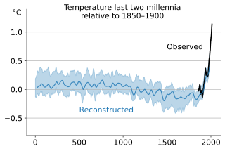
In the study of past climates ("paleoclimatology"), climate proxies are preserved physical characteristics of the past that stand in for direct meteorological measurements and enable scientists to reconstruct the climatic conditions over a longer fraction of the Earth's history. Reliable global records of climate only began in the 1880s, and proxies provide the only means for scientists to determine climatic patterns before record-keeping began.

The Last Glacial Maximum (LGM), also referred to as the Late Glacial Maximum, was the most recent time during the Last Glacial Period that ice sheets were at their greatest extent. Ice sheets covered much of North America, Northern Europe, and Asia and profoundly affected Earth's climate by causing drought, desertification, and a large drop in sea levels. According to Clark et al., growth of ice sheets commenced 33,000 years ago and maximum coverage was between 26,500 years and 19–20,000 years ago, when deglaciation commenced in the Northern Hemisphere, causing an abrupt rise in sea level. Decline of the West Antarctica ice sheet occurred between 14,000 and 15,000 years ago, consistent with evidence for another abrupt rise in the sea level about 14,500 years ago.

Frazil ice is a collection of loose, randomly oriented, plate or discoid ice crystals formed in supercooled turbulent water. Its formation is common during the winter in rivers and lakes located in northern latitudes, and usually forms in open-water reaches of rivers where and when the heat exchange between the air and the water is such that the water temperature can drop below its freezing point. As a rule of thumb, such conditions may happen on cold and clear nights, when the air temperature is lower than −6 °C (21 °F). Frazil ice also forms in oceans, where it is often referred to as grease ice when floating on the surface.
Parent material is the underlying geological material in which soil horizons form. Soils typically inherit a great deal of structure and minerals from their parent material, and, as such, are often classified based upon their contents of consolidated or unconsolidated mineral material that has undergone some degree of physical or chemical weathering and the mode by which the materials were most recently transported.

Coastal geography is the study of the constantly changing region between the ocean and the land, incorporating both the physical geography and the human geography of the coast. It includes understanding coastal weathering processes, particularly wave action, sediment movement and weather, and the ways in which humans interact with the coast
The Older Dryas was a stadial (cold) period between the Bølling and Allerød interstadials, about 14,000 years Before Present), towards the end of the Pleistocene. Its date is not well defined, with estimates varying by 400 years, but its duration is agreed to have been around 200 years.

The Quaternary glaciation, also known as the Pleistocene glaciation, is an alternating series of glacial and interglacial periods during the Quaternary period that began 2.58 Ma and is ongoing. Although geologists describe the entire time period up to the present as an "ice age", in popular culture the term "ice age" is usually associated with just the most recent glacial period during the Pleistocene or the Pleistocene epoch in general. Since planet Earth still has ice sheets, geologists consider the Quaternary glaciation to be ongoing, with the Earth now experiencing an interglacial period.

A tunnel valley is a U-shaped valley originally cut under the glacial ice near the margin of continental ice sheets such as that now covering Antarctica and formerly covering portions of all continents during past glacial ages. They can be as long as 100 km (62 mi), 4 km (2.5 mi) wide, and 400 m (1,300 ft) deep.

The Touchet Formation or Touchet beds consist of large quantities of gravel and fine sediment which overlay almost a thousand meters of volcanic basalt of the Columbia River Basalt Group in south-central Washington and north-central Oregon. The beds consist of between 6 and 40 distinct rhythmites – horizontal layers of sediment, each clearly demarcated from the layer below. These Touchet beds are often covered by windblown loess soils which were deposited later; the number of layers varies with location. The beds vary in depth from 330 ft (100 m) at lower elevations where a number of layers can be found to a few extremely thin layers at the maximum elevation where they are observed.
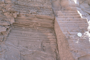
A rhythmite consists of layers of sediment or sedimentary rock which are laid down with an obvious periodicity and regularity. They may be created by annual processes such as seasonally varying deposits reflecting variations in the runoff cycle, by shorter term processes such as tides, or by longer term processes such as periodic floods.

The following outline is provided as an overview of and topical guide to the field of Meteorology.

Submarine landslides are marine landslides that transport sediment across the continental shelf and into the deep ocean. A submarine landslide is initiated when the downwards driving stress exceeds the resisting stress of the seafloor slope material, causing movements along one or more concave to planar rupture surfaces. Submarine landslides take place in a variety of different settings, including planes as low as 1°, and can cause significant damage to both life and property. Recent advances have been made in understanding the nature and processes of submarine landslides through the use of sidescan sonar and other seafloor mapping technology.

Lake Condon was a temporary lake in the Pacific Northwest region of North America, formed periodically by the Missoula Floods from 15,000 to 13,000 BC.

Overdeepening is a characteristic of basins and valleys eroded by glaciers. An overdeepened valley profile is often eroded to depths which are hundreds of metres below the deepest continuous line along a valley or watercourse. This phenomenon is observed under modern day glaciers, in salt-water fjords and fresh-water lakes remaining after glaciers melt, as well as in tunnel valleys which are partially or totally filled with sediment. When the channel produced by a glacier is filled with debris, the subsurface geomorphic structure is found to be erosionally cut into bedrock and subsequently filled by sediments. These overdeepened cuts into bedrock structures can reach a depth of several hundred metres below the valley floor.
The 20 indian Antarctic Expedition was flagged off on-board M.V. Magdalena Oldenorff from Cape Town on 30 December 2000. The team comprising a total of 51 members was led by Shri Mervin J. D’Souza from Geological Survey of India. The 20th IAE team consisted of 51 members including 34 scientists from various scientific Organizations/Universities/Departments and 17 logistic members. After successful completion of all logistics and scientific tasks the 20th IAE team returned to India in March 2002.

The Penultimate Glacial Period (PGP) is the glacial age that occurred before the Last Glacial Period. The penultimate glacial period is officially unnamed just like the Last Glacial Period. The word penultimate simply means second to last. While the penultimate glacial period is a part of the ongoing Quaternary ice age, which began 2.58 million years ago, the penultimate glacial period lasted from ~194,000 years ago, to ~135,000 years ago. The penultimate glacial period also occurred during the Marine Isotope age 6 (MIS6). At the glacial ages’ height, it is known to be the most extensive expansion of glaciers in the last 400,000 years over Eurasia, and could be the second or third coolest glacial period over the last 1,000,000 years, as shown by ice cores. Due to this, the global sea level dropped to between 92 and 150 metres below modern-day global mean sea level. The penultimate glacial period expanded ice sheets and shifted temperature zones worldwide, which had a variety of effects on the world’s environment, and the organisms that lived in it. At its height, the penultimate glacial period was a more severe glaciation than the Last Glacial Maximum.

The Chinese Loess Plateau, or simply the Loess Plateau, is a plateau in China characterized by yellow wind-blown sediment, compacted to become loess, which formed mainly in the Quaternary period. It is located southeast of the Gobi Desert and surrounded by the Yellow River, including parts of the Chinese provinces of Gansu, Shaanxi and Shanxi. The depositional setting of the Chinese Loess Plateau was shaped by the tectonic movement in the Neogene period, after which strong southeast winds caused by the East Asian Monsoon transported sediment to the plateau during the Quaternary period. The three main morphological types in the Loess Plateau are loess platforms, ridges and hills, formed by the deposition and erosion of loess. Most of the loess comes from the Gobi Desert and other nearby deserts. The sediments were transported to the Loess Plateau during interglacial periods by southeasterly prevailing winds and winter monsoon winds. After the deposition of sediments on the plateau, they were gradually compacted to form loess under the arid climate.
References
- ↑ http://treephys.oxfordjournals.org/content/30/6/669.full.pdf+html | "The median values for height, stem diameter and all biomass measurements at elevated growth temperatures were always near 1 for evergreens, indicating that for every study that found increased growth with warming, there were a similar number that found a decrease "