The Stuart River or Nak'alkoh is one of the largest tributaries of the Nechako River in northeastern British Columbia, Canada. The Nechako is in turn one the more important tributaries of the Fraser River. The Stuart River flows 187 kilometres (116 mi) from Stuart Lake to its junction with the Nechako River. The river drains a portion of the Nechako Plateau—a gently-rolling region characterized by small lakes and tributaries. Low but impressive ridges interact with the river, creating high bluffs and hoodoos.
Area code 250 is a telephone area code in the North American Numbering Plan (NANP) for the Canadian province of British Columbia outside the Lower Mainland, including Vancouver Island–home to the provincial capital, Victoria–and the province's Interior region. In addition, the numbering plan area extends into the United States community of Hyder, Alaska, located along the Canada–United States border near the town of Stewart. The incumbent local exchange carriers that service the area code are Telus, Northwestel, and CityWest in the city of Prince Rupert.
Tl'azt'en Nation is a First Nations band located along the north shore of Stuart Lake near the outlet of the Tache River, in the northern interior of British Columbia. The main village belonging to Tl'azt'en Nation is Tache, 60 km north-west of Fort St. James.The small settlements of Middle River on Trembleur Lake and Grand Rapids, along the Tache River between Stuart Lake and Trembleur Lake also belong to Tl'azt'en Nation. The main administrative offices are in Tache, as a school - Eugene Joseph Elementary School, Daycare, Head Start, Health Unit, Education Centre/ Learning Centre for Adults, RCMP/ Justice Office, Public Works building that supplies diesel and gasoline, water treatment plant, a newly built youth recreation center (2012), a Catholic and Christian church, one in Old Tache and one in "sunny side", a volunteer fire department with a fire hall; rec sites include a paintball park, a basket ball court and a hockey rink. The village of Portage once belonged to Tla'zt'en Nation but separated in 1994. The village of Pinchie once belonged to Tl'azt'en Nation separated on March 12, 2019. Prior to 1988 Tl'azt'en Nation was known as the Stuart-Trembleur band. Tl'azt'en Nation belongs to the Carrier Sekani Tribal Council.
Area codes 306, 639, and 474 are telephone area codes in the North American Numbering Plan (NANP) for the entire Canadian province of Saskatchewan. Area code 306 is the original area code, and area codes 639 and 474 were added to create an overlay plan for the entire province. The incumbent local exchange carrier is SaskTel.

Finger-Tatuk Provincial Park is a provincial park in British Columbia, Canada. Established in 1999, it covers 17,151 hectares and includes Finger Lake and Tatuk Lake, as well as several smaller lakes and archaeological sites once used by Dakelh (Carrier) First Nations peoples. The lakes are known for rainbow trout and kokanee salmon, and each of the two larger lakes has a resort.

Paarens Beach Provincial Park is a provincial park in central British Columbia, Canada. It is located on the south-west shore of Stuart Lake, to the west of Fort St. James.
Sowchea Bay Provincial Park is a provincial park in central British Columbia, Canada. It is on Stuart Lake, west of Prince George. The park is 13 hectares in area. It is a busy destination for boaters and anglers, with a single lane concrete boat launch available with limited parking.
Stuart River Provincial Park is a provincial park in British Columbia, Canada. It is located in two sections north and northwest of Vanderhoofalong the Stuart River southeast of Stuart Lake and the city of Fort St. James. The upper section is located at 54°13′20″N124°00′00″W and comprises c.7391 ha. while the lower, eastern section is centred at 54°03′00″N123°37′00″W and comprises c.3390 ha. and is within the Greater Prince George area. The upper site, which is located around the confluence of the Stuart and Nechako Rivers, includes the site of Chinlac, a Dakelh village whose inhabitants were massacred and enslaved by the Tsilhqot'in of Anahim Lake c. 1745.
Trembleur Lake Provincial Park is a provincial park in British Columbia, Canada.
Takla Lake Nation is a First Nation located around Takla Lake, 400 km north of Prince George, British Columbia, Canada. The main community is at Takla Landing, at the north end of Takla Lake, but the band services 17 reserves totaling 809 hectares. Takla Lake First Nation has approximately 650 members. It was created by the amalgamation of the Takla Lake and Fort Connelly bands in 1959.
Yekooche First Nation is based 75 kilometers northwest of Fort St. James, British Columbia at the north end of Stuart Lake on Yekooche reserves. It is known in English as Portage due to its location along the portage route between Babine Lake and Stuart Lake.
The Kluskus First Nation is the band government of the Lhoosk’uz, a Dakelh people whose main reserve located on the Chilcotin Plateau 130 km west of the city of Quesnel, British Columbia, Canada. The First Nation is a member of the Carrier-Chilcotin Tribal Council, which includes both Tsilhqot'in and Carrier (Dakelh) communities.
The Tŝideldel First Nation is the band government of the Tsi Del Del subgroup of the Tsilhqot'in people, located in the Chilcotin District in the western Central Interior region of the Canadian province of British Columbia. It is a member of the Tsilhqot'in National Government.
The following radio stations broadcast on AM frequency 760 kHz: WJR in Detroit, Michigan is the only class A station in North America broadcasting on 760 AM; 760 AM is a U.S. clear-channel frequency.
The Middle River, or in the Carrier language (Dakelh) Dzitl'ainli Koh, is a river in the Omineca Country of the northwestern Central Interior of British Columbia, Canada, flowing southeast from the outlet of Takla Lake into Trembleur Lake over a distance of approximately 35 kilometres (22 mi). The river is part of the route of the Stuart River-Takla Lake salmon run, which comes up the Fraser River via its tributaries the Nechako and Stuart Rivers and terminates at Takla Lake, and the route of the unfinished Dease Lake Extension of the British Columbia Railway runs along the river's left (north) bank. The community of Middle River, including the Dzitline Lee Indian Reserve 9. O K'Ay Wha Cho 26, another Indian Reserve, is located on the west bank of the river between Takla and Trembleur Lakes.
Loon Lake, British Columbia may refer to one of a number of lakes in this province of Canada with this precise name or to others with similar names.
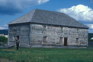
Fort St. James is a district municipality and former fur trading post in northern central British Columbia, Canada. It is located on the south-eastern shore of Stuart Lake in the Omineca Country, at the northern terminus of Highway 27, which connects to Highway 16 at Vanderhoof.
Grand Rapids is a Dakelh community northwest of Fort St. James, British Columbia, Canada, located at the confluence of the Tachie and Kuzkwa Rivers near Trembleur Lake. It is on the site of Kuz Che Indian Reserve No. 5, formerly named Grand Rapide IR No. 5. Nearby [is Tsay Cho IR No. 5, formerly named Stevan IR No. 4. These reserves are under the administration of the Tl'azt'en Nation. Kuz Che is an anglicization of the Carrier name, which is K'uz̲che.
The Tachie River is a river in central British Columbia, Canada. It originates at Trembleur Lake and flows southeastward into Stuart Lake, which it enters at Tachie village. In the indigenous Carrier language it is called Duz̲dlikoh, which means ``driftwood flows river.
