
Oliver Goldsmith was an Anglo-Irish writer best known for his works The Vicar of Wakefield (1766), The Good-Natur'd Man (1768), The Deserted Village (1770) and She Stoops to Conquer (1771). He is thought by some to have written the classic children's tale The History of Little Goody Two-Shoes (1765).
Tang is a village and a 'half-parish' in County Westmeath, on the N55 national secondary road between Athlone and Ballymahon, County Longford. Tang forms part of the ecclesiastical parish of Drumraney. It is in County Westmeath but on the border with County Longford from which it is separated by the Dungorman River which flows into Lough Ree 3 km downstream via the River Inny. The village is 15 km north-east of Athlone

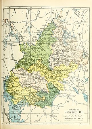
County Longford is a county in Ireland. It is in the province of Leinster. It is named after the town of Longford. Longford County Council is the local authority for the county. The population of the county was 46,634 at the 2022 census. The county is based on the historic Gaelic territory of Annaly (Anghaile), formerly known as Teffia (Teathbha).

Ballymahon on the River Inny is a town in the southern part of County Longford, Ireland. It is 19 km north-east of Athlone, at the junction of the N55 and R392 roads.

The Royal Canal is a canal originally built for freight and passenger transportation from Dublin to Longford in Ireland. It is one of two canals from Dublin to the River Shannon and was built in direct competition to the Grand Canal. The canal fell into disrepair in the late 20th century, but much of it has since been restored for navigation. The length of the canal to the River Shannon was reopened on 1 October 2010, but a final spur branch, to Longford Town, remains closed.

Straffan is a village in County Kildare, Ireland, situated on the banks of the River Liffey, 25 km upstream of the Irish capital Dublin. As of the 2016 census, the village had a population of 853, a nearly two-fold increase since the 2006 census.

Tullynally Castle, also known as Pakenham Hall, is a country house situated some 2 km from Castlepollard on the Coole village road in County Westmeath, Ireland. The Gothic-style building has over 120 rooms and has been home to the Pakenham family for over 350 years.

Ardagh is a village in County Longford, Ireland. Ardagh is located towards the south of County Longford, 10 kilometres (6.2 mi) southwest of Longford town, located off the N4 road. Originally a site of pre-Christian worship, Ardagh became a site of Christian settlement with the arrival of Saint Patrick sometime between 434 and 435. The bulk of the village was laid-out in the mid-19th century. The barony of Ardagh is named for the village. There is also a civil parish of the same name.

The Diocese of Ardagh and Clonmacnoise is a Latin Church diocese of the Catholic Church in Ireland.

Britford is a village and civil parish beside the River Avon about 1.5 miles (2.4 km) south-east of Salisbury in Wiltshire, England. The village is just off the A338 Salisbury-Bournemouth road. The 2011 Census recorded a parish population of 592.

The River Inny is a river within the Shannon River Basin in Ireland. It is 88.5 kilometres (55.0 mi) in length, and has a number of lakes along its course.

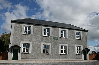
Forgney is a civil parish and townland in County Longford, Ireland. Evidence of ancient settlement in the area include a number of ringfort and holy well sites in Forgney townland. The townland, which has an area of approximately 3.1 square kilometres (1.2 sq mi), had a population of 77 people as of the 2011 census.
Brickeens is a very small townland in County Longford, Ireland. It is about five kilometres north of Keenagh and eight kilometres south of Longford town. Brickeens townland has an area of approximately 146 acres (0.2 sq mi), and had a population of 21 people as of the 2011 census. Evidence of ancient settlement in the townland include two ringforts.
Portlick Castle is a late medieval tower house castle near the village of Glasson, County Westmeath, Ireland. It is located approximately 6 miles from Athlone on the shores of Lough Ree. It comprises a square late medieval 4-storey stone tower with an attached 2-storey Georgian wing and Victorian tower.

Killiney Hill is the southernmost of the two hills which form the southern boundary of Dublin Bay, the other being Dalkey Hill. These two hills form part of Killiney Hill Park.
The High Sheriff of Longford was the British Crown's judicial representative in County Longford, Ireland from the 16th century until 1922, when the office was abolished in the new Free State and replaced by the office of Longford County Sheriff. The sheriff had judicial, electoral, ceremonial and administrative functions and executed High Court Writs. In 1908, an Order in Council made the Lord-Lieutenant the Sovereign's prime representative in a county and reduced the High Sheriff's precedence. However the sheriff retained his responsibilities for the preservation of law and order in the county. The usual procedure for appointing the sheriff from 1660 onwards was that three persons were nominated at the beginning of each year from the county and the Lord Lieutenant then appointed his choice as High Sheriff for the remainder of the year. Often the other nominees were appointed as under-sheriffs. Sometimes a sheriff did not fulfil his entire term through death or other event and another sheriff was then appointed for the remainder of the year. The dates given hereunder are the dates of appointment. All addresses are in County Longford unless stated otherwise.
Doory Hall is an estate and now-ruined historic building in County Longford, Ireland. While some parts of the estate are included on Longford County Council's Record of Protected Structures, the 19th century manor house itself is now a largely empty "shell".

Kilkenny West, previously Maherquirke or Dillons country, is a barony in west County Westmeath, Ireland. It was formed by 1542. It is bordered by County Longford to the west; it is also bordered by three other Westmeath baronies: Rathconrath, Brawny and Clonlonan. The largest centre of population in the barony is the village of Glassan.
Rathcline is a barony in County Longford, Ireland.

Between the 5th and 12th centuries, an Irish sept claiming descent from Coirpre mac Néill ruled a barony of north Tethbae, called Cairpre Gabra. Their territory corresponds to the barony of Granard in modern county Longford in Ireland.
