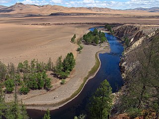
The Orkhon River is a river in Mongolia.

The Argun or Ergune is a 1,620-kilometre (1,010 mi) long river that forms part of the eastern China–Russia border, together with the Amur. Its upper reaches are known as Hailar River in China. The Argun marks the border between Russia and China for about 944 kilometres (587 mi), until it meets the Amur.
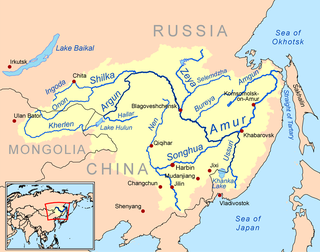
The Onon is a river in Mongolia and Russia. It is 1,032 kilometres (641 mi) long, and has a drainage basin of 96,200 square kilometres (37,100 sq mi).

Khanui River is a river flowing down through the valleys of the Khangai Mountains in central Mongolia. It starts in the Chuluut sum of Arkhangai aimag at the north slopes of the Khan-Öndör mountain. It passes next to the center of Erdenemandal sum, and ends in the Khutag-Öndör sum of Bulgan aimag where it discharges into the Selenge. It is 421 kilometres (262 mi) long, and has a drainage basin of 14,600 square kilometres (5,600 sq mi).

The Tuul River or Tula River is a river in central and northern Mongolia. Sacred to the Mongols, the Tuul is generally called the Hatan Tuul. It is 882.8 kilometres or 549 miles long and drains an area of 49,840 square kilometres or 19,240 square miles. The Secret History of the Mongols frequently mentions a "Black Forest of the Tuul River" where the palace of Ong Khan was located.

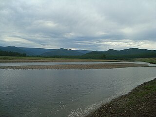
The Khalkh River is a river in eastern Mongolia and northern China's Inner Mongolia region. The river is also referred to with the Mongolian genitive suffix -iin as the Khalkhin Gol, or River of Khalkh.
The Chikoy is a river in Zabaykalsky Krai and the Buryat Republic in Russia, which partially flows along the Russia-Mongolia border. It is a right tributary of the Selenga. The length of the Chikoy is 769 kilometres (478 mi). The area of its basin is 46,200 square kilometres (17,800 sq mi).
The Üür River is a river in the Khövsgöl aimag of northern Mongolia. It starts in about 30 km from the Russian border in Tsagaan-Üür sum, from the confluence of the Old Üür and the Young Üür . The river is a tributary of the Egiin Gol, which it meets in the Erdenebulgan sum.
Uilgan River is a river in the Tsagaan-Üür Sum of Khövsgöl Aimag in Mongolia.
Arigiin River is a river in the Khövsgöl aimag of Mongolia. It starts next to Döm Mountain in the confluence of two smaller rivers at the border between Alag-Erdene and Chandmani-Öndör sums, continuing through the latter. It discharges into the Üür River next to the Tsagaan-Üür sum center.
Tarvagatai River is a river in the Teshig sum of Bulgan aimag in Mongolia. It starts about 30 km north of the sum center of Selenge sum in the Angarkhai mountain range, and discharges into the Egiin Gol ca 55 km west of that.

Kharaa River is a river in central northern Mongolia. It starts in a confluence between Sögnögör River and Mandal River near the center of Batsümber sum in Töv aimag, and then continues in a roughly north-western direction through Selenge aimag. On the last stretch it flows through the Darkhan-Uul aimag, running along its western border and passing the city of Darkhan before entering the Orkhon River near the northern tip of the aimag.
Beltes River is a river in the Khövsgöl aimag of Mongolia.
Sharga River is a river in Khövsgöl aimag of northern Mongolia. It runs through the eastern part of "East Taiga", the north eastern extension of the Darkhad valley. The river starts as a confluence of several smaller rivers in the Tsagaannuur sum near the Russian border and exits into Dood Tsagaan Lake in the Renchinlkhümbe sum as a tributary of the Little Yenisey.
The Busiyn-Gol is a river in northern Mongolia and Tuva. It has its source in the southern Ulaan Taiga mountain range, meets the Russian border after about 50 km, and then follows the border north until its confluence with the Little Yenisey (Kyzyl-Khem). It is 129 kilometres (80 mi) long, and has a drainage basin of 2,380 square kilometres (920 sq mi).
Tengis River is a river in the Tsagaannuur sum of Khövsgöl aimag in northern Mongolia. It runs through the western part of "East Taiga", the northern extension of the Darkhad valley. The river starts near the Russian border, in the northernmost tip of Mongolia. It ends as a right hand tributary of the Little Yenisey.
The Suvraga Khairkhan is a mountain of the Khangai Mountains range in the Tsenkher, Arkhangai Province in Mongolia. It has an elevation of 3,179 metres (10,430 ft) and is considered a regional sacred mountain.

The Little Yenisey is a river in northern Mongolia and in Tuva, Russia. At its confluence with the Great Yenisey in Kyzyl (Tuva), the Yenisey is formed. It is 563 kilometres (350 mi) long, and has a drainage basin of 58,700 square kilometres (22,700 sq mi). It rises in the Darkhad Valley in northwestern Khövsgöl aimag in Mongolia.
The Ulaan Ovoo Coal Mine is a coal mine located in the Tüshig sum of Selenge aimag in northern Mongolia. It is located on the northern shore of the Zelter River a short distance west of the sum center.

The Zelter River or Zheltura is a river in northern Mongolia and Russia.

