
The Midlands is the central part of England and a cultural area that broadly corresponds to the early medieval Kingdom of Mercia. The Midlands region is bordered by Northern England and Southern England. The Midlands were important in the Industrial Revolution of the 18th and 19th centuries. Two of the nine official regions of England are the West Midlands and East Midlands. Birmingham, in the West Midlands, is the second-largest city and metropolitan area in the United Kingdom.
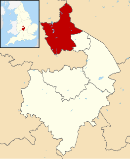
North Warwickshire is a local government district and borough in Warwickshire, England. The main town in the district is Atherstone where the offices of North Warwickshire Borough Council are based. Other significant places include Coleshill, Polesworth, Kingsbury and Hartshill. The district borders Staffordshire to the northwest, Leicestershire to the northeast, West Midlands county to the south and southwest, and the Warwickshire district of Nuneaton and Bedworth to the east.

East Staffordshire is a local government district with borough status in Staffordshire in England. It has two main towns: Burton upon Trent and Uttoxeter.
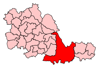
Meriden is a constituency represented in the House of Commons of the UK Parliament since 2019 by Saqib Bhatti, a Conservative. It is named after the village of Meriden which lies around halfway between the urban fringe of Solihull and Coventry.

Drayton Manor, one of Britain's lost houses, was a British stately home at Drayton Bassett, since its formation in the District of Lichfield, Staffordshire, England. In modern administrative areas, it was first put into Tamworth Poor Law Union and similar Rural Sanitary District, 1894 to 1934 saw its inclusion in Tamworth Rural District and in next forty years it lay in the 1974-abolished Lichfield Rural District.

Amington is a suburban village, parish and ward, in Staffordshire, England. Formerly a distinct village, it is now part of the Tamworth borough, with no gap between it and the neighbouring wards of Bolehall, Glascote, Glascote Heath and Stonydelph.
Atherstone was a rural district in the administrative county of Warwickshire, England, from 1894 to 1974. It was named after its main town and administrative headquarters of Atherstone.

Banbury was a rural district in Oxfordshire, England from 1894 to 1974. It was formed under the Local Government Act 1894 from the bulk of the Banbury rural sanitary district, which had been divided among three counties. The Warwickshire part of the rural sanitary district formed the Farnborough Rural District, whilst the area in Northamptonshire formed the Middleton Cheney Rural District.
Farnborough was a rural district in Warwickshire, England from 1894 to 1932.
Repton was a rural district in Derbyshire, England from 1894 to 1974.
Gnosall was a rural district in Staffordshire, England from 1894 to 1934. It was formed under the Local Government Act 1894 from that part of the Newport Rural Sanitary District which was in Staffordshire.
Cannock was a rural district in Staffordshire, England from 1894 to 1974.
Wood End is an old mining village in North Warwickshire, England. It lies to the south east of Tamworth and close to the border with Staffordshire. It grew around the former Kingsbury Colliery but now it serves as a commuter village to Tamworth. It has a church, a primary school, a co-operative store, a working men's club and a village hall. The population of Wood End is 2,205, but from the 2011 Census has been included in Kingsbury, Warwickshire.

The A423 road is a primary A road in England in two sections. The main section leads from central Banbury to the A45 near Coventry. It starts in Banbury town centre as Southam Road and goes through the Southam Road Industrial Estate, then just north of Banbury it crosses over the M40, from there it passes close to several Warwickshire villages until it becomes part of the Southam by-pass, it then goes through Long Itchington and Marton before merging with the A45 near Ryton.

Shuttington is a village and civil parish in North Warwickshire, England, situated north-east of Tamworth, Staffordshire. In the 2001 census, the parish, which also includes Alvecote, had a population of 563, decreasing to 536 at the 2011 census.
Birchmoor is a former coal mining village in the North Warwickshire district of Warwickshire, England. It lies about one mile south-west of Polesworth, and around 2m east of Tamworth, from which it is separated by the M42 motorway and the Staffordshire county boundary.

Thorpe Constantine is a small village and civil parish in Staffordshire, England. It lies about 6 miles (10 km) north-east of Tamworth and 6 miles south-west of Measham. The nucleus of the parish is the Thorpe estate.
Lichfield was a rural district in the county of Staffordshire, England from 1894 to 1974.

Grendon is a civil parish which includes both Old Grendon and New Grendon in North Warwickshire, England. Population details can be found under Baddesley Ensor.

Urban District of Perry Barr, or Perry Barr Urban District was an area of England for local government administrative purposes. As such, it was administered locally by Perry Barr Urban District Council. It took its name from the included hamlet of Perry Barr, which was until then in the parish of Handsworth. It was created in 1894 as a result of the Local Government Act 1894, as a subdivision of the administrative county of Staffordshire, and existed until 1928, when it largely became part of Birmingham, and so also part of the county of Warwickshire. At that time, small parts of the district were granted to the Royal Town of Sutton Coldfield, also in Warwickshire, and to West Bromwich. In 1974, Birmingham was taken out of Warwickshire and became part of the West Midlands county.