
The North York Moors is an upland area in north-eastern Yorkshire, England. It contains one of the largest expanses of heather moorland in the United Kingdom. The area was designated as a National Park in 1952, through the National Parks and Access to the Countryside Act 1949. Covering an area of 554 sq mi (1,430 km2), the National Park has a population of 23,380. It is administered by the North York Moors National Park Authority, whose head office is based in Helmsley.

Woolley Colliery is a village on the border between the Barnsley and Wakefield districts in Yorkshire, England. The village is now in South Yorkshire, while the former colliery was in the Wakefield Rural Ward in West Yorkshire. The village is known locally as Mucky Woolley, as a tribute to its coalmining heritage and to distinguish it from the more affluent village of Woolley two miles away.

The North Pennines is the northernmost section of the Pennine range of hills which runs north–south through northern England. It lies between Carlisle to the west and Darlington to the east. It is bounded to the north by the Tyne Valley and to the south by the Stainmore Gap.

Ingleton is a village and civil parish in the Craven district of North Yorkshire, England. The village is 19 miles (30 km) from Kendal and 17 miles (28 km) from Lancaster on the western side of the Pennines. It is 9.3 miles (15 km) from Settle. The River Doe and the River Twiss meet to form the source of the River Greta, a tributary of the River Lune. The village is on the A65 road and at the head of the A687. The B6255 takes the south bank of the River Doe to Ribblehead and Hawes. All that remains of the railway in the village is the landmark Ingleton Viaduct. Arthur Conan Doyle was a regular visitor to the area and was married locally, as his mother lived at Masongill from 1882 to 1917. It has been claimed that there is evidence that the inspiration for the name Sherlock Holmes came from here.

East Bowling is an area of Bradford, West Yorkshire, England located to the south of Bradford city centre. It forms the eastern half of the historic township and manor of Bowling. Bowling became a ward of the newly created Borough of Bradford in 1847. In 1882 the ward was split into the wards of East and West Bowling. In the north the boundary was along the Lancashire and Yorkshire Railway. To the south it was along Hall Lane and Bolling Hall Lane.

Caphouse Colliery, originally known as Overton Colliery, was a coal mine in Overton, near Wakefield, West Yorkshire, England. It was situated on the Denby Grange estate owned by the Lister Kaye family, and was worked from the 18th century until 1985. It reopened as the Yorkshire Mining Museum in 1988, and is now the National Coal Mining Museum for England.
The Upper Hirst is a coal seam in central Scotland that was mined on a large scale in the 1950s through to 2002, mainly to supply Kincardine Power Station, and later, Longannet Power Station, in Fife.
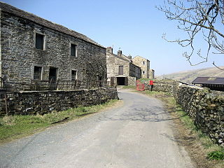
West Stonesdale is a hamlet in the Yorkshire Dales, North Yorkshire, England. The secluded village is near Keld to the south, Tan Hill to the north and is both 10 miles (16 km) from Grinton and Askrigg. The small valley that cuts south from Tan Hill to West Stonesdale is also known as West Stonesdale and carries Stonesdale Beck 4 miles (7 km) south to the River Swale. A road heads north from the B6270 through West Stonesdale to Tan Hill. Where the road diverges from the B6270 is the site of Currack Force, a waterfall on Stonesdale Beck which drops 23 feet (7 m) before entering the Swale.
Cortonwood was a colliery near Rotherham, South Yorkshire, England. The colliery's proposed closure was a tipping point in the 1984-85 miners' strike. The site is now a shopping and leisure centre.
The Somerset Coalfield in northern Somerset, England is an area where coal was mined from the 15th century until 1973. It is part of a larger coalfield which stretched into southern Gloucestershire. The Somerset coalfield stretched from Cromhall in the north to the Mendip Hills in the south, and from Bath in the east to Nailsea in the west, a total area of about 240 square miles (622 km2). Most of the pits on the coalfield were concentrated in the Cam Brook, Wellow Brook and Nettlebridge Valleys and around Radstock and Farrington Gurney. The pits were grouped geographically, with clusters of pits close together working the same coal seams often under the same ownership. Many pits shared the trackways and tramways which connected them to the Somerset Coal Canal or railways for distribution.

Kiveton Park Colliery was a coal mine in the village of Kiveton Park, near Rotherham, South Yorkshire, England.

Kellingley Colliery was a deep coal mine in North Yorkshire, England, 3.6 miles (5.8 km) east of Ferrybridge power station. It was owned and operated by UK Coal.
The South Yorkshire Coalfield is so named from its position within Yorkshire. It covers most of South Yorkshire, West Yorkshire and a small part of North Yorkshire. The exposed coalfield outcrops in the Pennine foothills and dips under Permian rocks in the east. Its most famous coal seam is the Barnsley Bed. Coal has been mined from shallow seams and outcrops since medieval times and possibly earlier.

The Lancashire Coalfield in North West England was an important British coalfield. Its coal seams were formed from the vegetation of tropical swampy forests in the Carboniferous period over 300 million years ago.
The Ingleton Coalfield is in North Yorkshire, close to its border with Lancashire in north-west England. Isolated from other coal-producing areas, it is one of the smallest coalfields in Great Britain.

The Manchester Coalfield is part of the South Lancashire Coalfield, the coal seams of which were laid down in the Carboniferous Period. Some easily accessible seams were worked on a small scale from the Middle Ages, and extensively from the beginning of the Industrial Revolution in the early 19th century until the last quarter of the 20th century. The Coal Measures lie above a bed of Millstone Grit and are interspersed with sandstones, mudstones, shales, and fireclays. The Lower Coal Measures occupy the high ground of the West Pennine Moors above Bolton and are not worked in the Manchester Coalfield. The most productive of the coal measures are the lower two thirds of the Middle Coal Measures where coal is mined from seams between the Worsley Four Foot and Arley mines. The deepest and most productive collieries were to the south of the coalfield. The coalfield is affected by the northwest to southeast aligned Pendleton Fault along the Irwell Valley and the Rossendale Valley anticline. The Coal Measures generally dip towards the south and west. Numerous other smaller faults affect the coalfield. The Upper Coal Measures are not worked in the Manchester Coalfield.
The Oldham Coalfield is the most easterly part of the South Lancashire Coalfield. Its coal seams were laid down in the Carboniferous period and some easily accessible seams were worked on a small scale from the Middle Ages and extensively from the beginning of the Industrial Revolution in the early 19th century until the middle of the 20th century.
Hapton Valley Colliery was a coal mine on the edge of Hapton near Burnley in Lancashire, England. Its first shafts were sunk in the early 1850s and it had a life of almost 130 years, surviving to be the last deep mine operating on the Burnley Coalfield.
Barrow Colliery was a coal mine in Worsborough, South Yorkshire, England. It was first dug in 1873, with the first coal being brought to the surface in January 1876. It was the scene of a major incident in 1907 when seven miners died. After 109 years of coaling operations, the mine was closed in May 1985.
Wether Fell, also known as Drumaldrace, is a mountain in the Yorkshire Dales National Park, in North Yorkshire, England. Wether Fell is mountain that divides Wensleydale in the north and Upper Wharfedale in the south. Its summit is 614 metres (2,014 ft). A Roman Road, the Cam High Road, passes along the southern edge of the summit reaching 1,900 feet (580 m).

