Tanacross Air Base

Last updated
Tanacross Air Base
Summary
Airport type Military
Owner United States Army
Location Tanacross, Alaska
Built 1943
Elevation  AMSL 1,549 ft / 472 m
Coordinates 63°22′28″N143°20′08″W / 63.37444°N 143.33556°W / 63.37444; -143.33556 Coordinates: 63°22′28″N143°20′08″W / 63.37444°N 143.33556°W / 63.37444; -143.33556
Map
USA Alaska location map.svg
Airplane silhouette.svg
Tanacross AB
Location of airport in Alaska
Runways
Direction Length Surface
ft m
6/24 5,100 1,554
12/30 5,000 1,524

Tanacross Air Base is a former United States Army airfield located one  nautical mile (2  km) south of the central business district of Tanacross, in the Southeast Fairbanks Census Area of the U.S. state of Alaska. [1]

United States Army Land warfare branch of the United States Armed Forces

The United States Army (USA) is the land warfare service branch of the United States Armed Forces. It is one of the seven uniformed services of the United States, and is designated as the Army of the United States in the United States Constitution. As the oldest and most senior branch of the U.S. military in order of precedence, the modern U.S. Army has its roots in the Continental Army, which was formed to fight the American Revolutionary War (1775–1783)—before the United States of America was established as a country. After the Revolutionary War, the Congress of the Confederation created the United States Army on 3 June 1784 to replace the disbanded Continental Army. The United States Army considers itself descended from the Continental Army, and dates its institutional inception from the origin of that armed force in 1775.

Nautical mile unit of distance (1852 m)

A nautical mile is a unit of measurement used in both air and marine navigation, and for the definition of territorial waters. Historically, it was defined as one minute of a degree of latitude. Today it is defined as exactly 1852 metres. The derived unit of speed is the knot, one nautical mile per hour.

The kilometre or kilometer is a unit of length in the metric system, equal to one thousand metres. It is now the measurement unit used officially for expressing distances between geographical places on land in most of the world; notable exceptions are the United States and the road network of the United Kingdom where the statute mile is the official unit used.

Contents

History

Constructed 1943, activated September 20 by Air Transport Command as Station #16, Alaskan Wing, later 1464th AAFBU. Alaskan Division, ATC. It was auxiliary to Ladd Army Airfield for Northwest Staging Route Lend-Lease aircraft. The facility was designated Tanacross Air Base in July 1944. Its mission was servicing Northwest Staging Route Lend-Lease aircraft from United States. The facility was transferred to Eleventh Air Force, then to Alaskan Air Command in 1945 and closed; it was turned over to War Assets Administration for disposition in 1946. [2]

Ladd Army Airfield

Ladd Army Airfield is the military airfield located at Fort Jonathan Wainwright, located in Fairbanks, Alaska. It was originally called Fairbanks Air Base, but was renamed Ladd Field on 1 December 1939, in honor of Major Arthur K. Ladd, a pilot in the U.S. Army Air Corps who died in a plane crash near Dale, South Carolina on 13 December 1935.

Northwest Staging Route air route in Alaska and northern/western Canada during World War II

The Northwest Staging Route was a series of airstrips, airport and radio ranging stations built in Alberta, British Columbia, the Yukon and Alaska during World War II. It extended into the Soviet Union as the ALSIB.

Lend-Lease United States foreign policy during World War II

The Lend-Lease policy, formally titled An Act to Promote the Defense of the United States, was an American program to defeat Germany, Japan and Italy by distributing food, oil, and materiel between 1941 and August 1945. The aid went to the United Kingdom, China, and later the Soviet Union, Free France, and other Allied nations. It included warships and warplanes, along with other weaponry. The policy was signed into law on March 11, 1941, and ended overnight without prior warning when the war against Japan ended. The aid was free for all countries, although goods in transit when the program ended were charged for. Some transport ships were returned to the US after the war, but practically all the items sent out were used up or worthless in peacetime. In Reverse Lend Lease, the U.S. was given no-cost leases on army and naval bases in Allied territory during the war, as well as local supplies.

Jurisdiction transferred to private ownership in 1947 and redeveloped as Tanacross Airport. One of the hangars at the site later became the Big Dipper Ice Arena in Fairbanks.

Tanacross Airport

Tanacross Airport is a public use airport located one nautical mile (2 km) south of the central business district of Tanacross, in the Southeast Fairbanks Census Area of the U.S. state of Alaska. It is owned by the Bureau of Land Management.

Big Dipper Ice Arena

The Big Dipper Ice Arena, colloquially known as "The Big Dipper", is a multi-purpose arena in Fairbanks, Alaska. The arena is owned and operated by the Fairbanks North Star Borough. Originally constructed as an airplane hangar for the Lend-Lease program in Tanacross, southeast of Fairbanks, the building was dismantled, transported to Fairbanks and reassembled in 1968. It has undergone two major renovations since then. The building is home to the Fairbanks Ice Dogs ice hockey team. The borough's parks and recreation department is headquartered in the building.

See also

During World War II, Alaska was a major United States Army Air Forces (USAAF) location for personnel, aircraft, and airfields to support Lend-Lease aid for the Soviet Union. In addition, it was in Alaska that the Empire of Japan seized United States territory and as a result the USAAF was actively engaged in combat operations against them.

Related Research Articles

Eleventh Air Force Numbered air force of the United States Air Force responsible for the Alaskan region

The Eleventh Air Force (11 AF) is a Numbered Air Force of the United States Air Force Pacific Air Forces (PACAF). It is headquartered at Joint Base Elmendorf–Richardson, Alaska.

Air Transport Command United States Army Air Forces command responsible for transport and ferrying aircraft

Air Transport Command (ATC) was a United States Air Force unit that was created during World War II as the strategic airlift component of the United States Army Air Forces.

Edward G. Pitka Sr. Airport

Edward G. Pitka Sr. Airport is a state owned, public use airport located in Galena, a city in the Yukon-Koyukuk Census Area of the U.S. state of Alaska.

Northway Airport

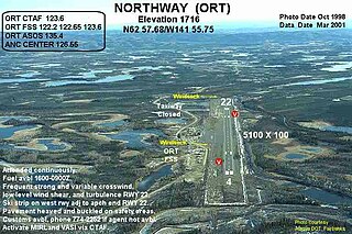
Northway Airport is a state owned, public use airport serving Northway, a community located in the Southeast Fairbanks Census Area of the U.S. state of Alaska. It is included in the National Plan of Integrated Airport Systems for 2011–2015, which categorized it as a general aviation facility.

Marks Air Force Base former United States Air Force facility

Marks Air Force Base is a former United States Air Force facility located two nautical miles (4 km) west of the central business district of Nome, a city in the Nome Census Area of the U.S. state of Alaska. Following its closure, it was redeveloped into Nome Airport.

Naknek Air Force Base

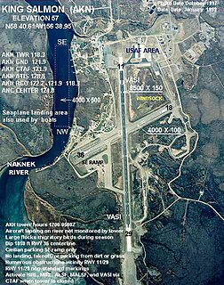
Naknek Air Force Base is a former United States Air Force base located just southeast of King Salmon, in the Bristol Bay Borough of the U.S. state of Alaska. Following its closure, it has since been redeveloped into King Salmon Airport.

ALSIB Soviet portion of the Northwest Staging air route during World War II

ALSIB was the Soviet Union portion of the Alaska-Siberian air road receiving Lend-Lease aircraft from the Northwest Staging Route. Aircraft manufactured in the United States were flown over this route for World War II combat service on the Eastern Front.

Allen Army Airfield

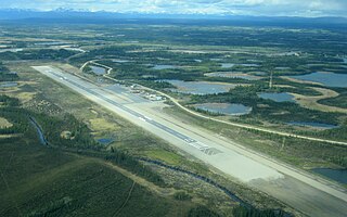
Allen Army Airfield is a public and military use airport serving Fort Greely and located three miles (5 km) south of the central business district of Delta Junction, a city in the Southeast Fairbanks Census Area of the U.S. state of Alaska. It is owned by the United States Army, which has an agreement with the City of Delta Junction for joint use of the airfield by both military and civilian aircraft.

Minneapolis–Saint Paul Joint Air Reserve Station United States Air Force base, located at Minneapolis–Saint Paul International Airport

Minneapolis–Saint Paul Joint Air Reserve Station is a United States Air Force base, located at Minneapolis–Saint Paul International Airport. It is located 7.1 miles (11.4 km) south-southeast of Minneapolis, Minnesota. It was formerly the location of Naval Air Station Twin Cities.

Thornbrough Air Force Base

Thornbrough Air Force Base is a former facility of the United States Air Force in Cold Bay, Alaska. Following its closure, it was redeveloped into Cold Bay Airport.

Bowers Airport public airport just north of Ellensburg, Washington

Bowers Field is a county-owned, public-use airport in Kittitas County, Washington, United States. It is located two nautical miles (4 km) north of the central business district of Ellensburg, Washington. This airport is included in the National Plan of Integrated Airport Systems for 2011–2015, which categorized it as a general aviation facility.

Gambell Army Airfield

Gambell Army Airfield is a former United States Army airfield located in Gambell, a city in the Nome Census Area of the U.S. state of Alaska.

Northway Army Airfield

Northway Army Airfield is a former United States Army airfield located in Northway, a community located in the Southeast Fairbanks Census Area of the U.S. state of Alaska. During World War II for northbound Lend-Lease aircraft on the Northwest Staging Route, the flight strip at Northway was the first stop in the Territory of Alaska.. It is now the state owned Northway Airport.

The West Coast Wing (WCW) is an inactive United States Air Force unit. Its last assignment was with the Pacific Division, Air Transport Command, headquartered at Fairfield-Suisun Air Force Base, California. It was inactivated on 30 September 1946.

Joint Base Elmendorf–Richardson United States military facility in Anchorage, Alaska

Joint Base Elmendorf–Richardson is a United States military facility in Anchorage, the largest city in Alaska. It is an amalgamation of the United States Air Force's Elmendorf Air Force Base and the United States Army's Fort Richardson, which were merged in 2010.

McGrath Army Airbase

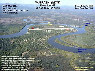
McGrath Army Airbase is former United States Army airbase located in McGrath, a city in the Yukon-Koyukuk Census Area of the U.S. state of Alaska.

Moses Point Army Airfield

Moses Point Army Airfield is a former United States Army airfield located in Elim, a city in the Nome Census Area of the U.S. state of Alaska.

Bethel Air Base

Bethel Air Base is a former United States Army airfield located three nautical miles (6 km) southwest of the central business district of Bethel, a city in the Bethel Census Area of the U.S. state of Alaska.

References

  1. 1 2 FAA Airport Master Record for TSG ( Form 5010 PDF ). Federal Aviation Administration. Effective August 25, 2011.
  2. PD-icon.svg This article incorporates  public domain material from the Air Force Historical Research Agency website http://www.afhra.af.mil/ .