St. Lawrence Island is located west of mainland Alaska in the Bering Sea, just south of the Bering Strait. The village of Gambell, located on the northwest cape of the island, is 50 nautical miles from the Chukchi Peninsula in the Russian Far East. The island is part of Alaska, but closer to Russia and Asia than to the Alaskan and North American mainland. St. Lawrence Island is thought to be one of the last exposed portions of the land bridge that once joined Asia with North America during the Pleistocene period. It is the sixth largest island in the United States and the 113th largest island in the world. It is considered part of the Bering Sea Volcanic Province. The Saint Lawrence Island shrew is a species of shrew endemic to St. Lawrence Island. The island is jointly owned by the predominantly Siberian Yupik villages of Gambell and Savoonga, the two main settlements on the island.

The Northwest Staging Route was a series of airstrips, airport and radio ranging stations built in Alberta, British Columbia, Yukon and Alaska during World War II. It extended into the Soviet Union as the ALSIB.

The Eleventh Air Force (11 AF) is a Numbered Air Force of the United States Air Force Pacific Air Forces (PACAF). It is headquartered at Joint Base Elmendorf–Richardson, Alaska.

Air Transport Command (ATC) was a United States Air Force unit that was created during World War II as the strategic airlift component of the United States Army Air Forces.

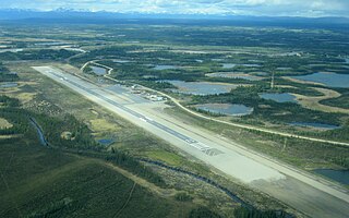
Edward G. Pitka Sr. Airport is a state-owned public-use airport located in Galena, a city in the Yukon-Koyukuk Census Area of the U.S. state of Alaska.

Ladd Army Airfield is the military airfield located at Fort Wainwright in Fairbanks, Alaska. It was originally called Fairbanks Air Base, but was renamed Ladd Field on 1 December 1939, in honor of Major Arthur K. Ladd, a pilot in the U.S. Army Air Corps who died in a plane crash near Dale, South Carolina on 13 December 1935.

Gambell Airport is a public airport located in Gambell, a city in the Nome Census Area of the U.S. state of Alaska. The airport is owned by the state.

Marks Air Force Base is a former United States Air Force facility located two nautical miles (4 km) west of the central business district of Nome, a city in the Nome Census Area of the U.S. state of Alaska. It was named in honor of Major Jack S. Marks, a United States Army Air Forces pilot based at Ladd Army Airfield who died when his aircraft was shot down over the Aleutians in July 1942. Following its closure, it was redeveloped into Nome Airport.

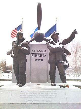
ALSIB was the Soviet Union portion of the Alaska-Siberian air road receiving Lend-Lease aircraft from the Northwest Staging Route. Aircraft manufactured in the United States were flown over this route for World War II combat service on the Eastern Front.

Allen Army Airfield is a public and military use airport serving Fort Greely and located three miles (5 km) south of the central business district of Delta Junction, a city in the Southeast Fairbanks Census Area of the U.S. state of Alaska. It is owned by the United States Army, which has an agreement with the City of Delta Junction for joint use of the airfield by both military and civilian aircraft.

Cape Field at Fort Glenn was a military site significant for its role in World War II. It consists of Fort Glenn, an airfield of the United States Army Air Corps later renamed Cape Air Force Base, and the adjacent Naval Air Facility Otter Point, both located on Umnak Island in the Aleutian Islands of southwestern Alaska. The site was listed on the National Register of Historic Places and declared a National Historic Landmark in 1987.
During World War II, the United States Army Air Forces (USAAF) established numerous airfields in California for training pilots and aircrews of USAAF fighters and bombers.

Thornbrough Air Force Base is a former facility of the United States Air Force in Cold Bay, Alaska. Following its closure, it was redeveloped into Cold Bay Airport.

The North Atlantic air ferry route was a series of Air Routes over the North Atlantic Ocean on which aircraft were ferried from the United States and Canada to Great Britain during World War II to support combat operations in the European Theater of Operations (ETO).
Gakona Landing Strip is an abandoned airfield located near Gakona in the U.S. state of Alaska.

On February 27, 1974, a Soviet Antonov An-24LR "Toros" (CCCP-47195) ice reconnaissance aircraft landed at Gambell Airport, Alaska. The plane, carrying three crew members and twelve scientists, was en route to Anadyr, USSR. Due to strong winds, the pilot decided to divert to Provideniya, USSR, which was fogged in. The aircraft was low on fuel, so the crew chose to divert to Gambell, United States, located 62 miles (100 km) southeast of Provideniya, USSR, across the Bering Sea. The plane made a straight-in approach, and one of the engines quit shortly before landing due to fuel starvation.
Cape Air Force Base also known as Fort Glenn Army Air Base, is a site significant for its role in World War II fighting, operating alongside Naval Air Facility Otter Point.
Tanacross Air Base is a former United States Army airfield located one nautical mile (2 km) south of the central business district of Tanacross, in the Southeast Fairbanks Census Area of the U.S. state of Alaska.

Northway Army Airfield is a former United States Army airfield located in Northway, a community located in the Southeast Fairbanks Census Area of the U.S. state of Alaska. During World War II for northbound Lend-Lease aircraft on the Northwest Staging Route, the flight strip at Northway was the first stop in the Territory of Alaska. It is now the state owned Northway Airport.

Bethel Air Base is a former United States Army airfield located three nautical miles (6 km) southwest of the central business district of Bethel, a city in the Bethel Census Area of the U.S. state of Alaska.


