
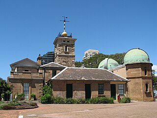
The Rocks is an urban locality, tourist precinct and historic area of Sydney's city centre, in the state of New South Wales, Australia. It is located on the southern shore of Sydney Harbour, immediately north-west of the Sydney central business district.

Cooma is a town in the south of New South Wales, Australia. It is located 114 kilometres (71 mi) south of the national capital, Canberra, via the Monaro Highway. It is also on the Snowy Mountains Highway, connecting Bega with the Riverina.

Tathra is a seaside town on the Sapphire Coast found on the South Coast, New South Wales, Australia. As at the 2016 census, Tathra had a population of 1,675.

The Hills Shire is a local government area in the Greater Western Sydney region of Sydney, New South Wales, Australia. The suburb is north-west of the Sydney central business district, and encompasses 401 square kilometres (155 sq mi) stretching from the M2 Hills Motorway in the south to Wiseman's Ferry on the Hawkesbury River in the north. The Hills Shire had a population of 157,243 as at the 2016 census.

The Bega Valley Shire is a local government area located adjacent to the south-eastern coastline of New South Wales, Australia. The Shire was formed in 1981 with the amalgamation of the Municipality of Bega, Imlay Shire and Mumbulla Shire. The estimated population as at the 2016 census was 33,253.

Bega is a town in the south-east of New South Wales, Australia in the Bega Valley Shire. It is the economic centre for the Bega Valley.

Linden is a village in the Blue Mountains of New South Wales, Australia. It is in the City of Blue Mountains, 81 km west of Sydney and 19 km east of Katoomba. The village is on the Great Western Highway and has a railway station on the Main Western railway line served by NSW TrainLink's Blue Mountains Line. It shares a post office, and therefore the 2778 postcode, with adjoining Woodford. In the 2011 census, its population was 594, including 19 indigenous people (3.2%).
Pambula is a town in Bega Valley Shire on the far south coast of New South Wales, Australia 473 kilometres (294 mi) south of Sydney via the Princes Highway. At the 2016 census, Pambula had a population of 970 people.

The City of Penrith is a local government area in the state of New South Wales, Australia. The seat of the city is located in Penrith, located about 50 kilometres (31 mi) west of Sydney's central business district. It occupies part of the traditional lands of the Darug people. First incorporated as a municipality on 12 May 1871, on 1 January 1949, the municipalities of Penrith, St Marys and Castlereagh and part of the Nepean Shire amalgamated to form a new Municipality of Penrith. Penrith was declared a City on 21 October 1959, and expanded westwards to include Emu Plains and Emu Heights, formerly part of the City of Blue Mountains, on 25 October 1963. As at the 2016 census the City of Penrith had an estimated population of 196,066.
Millers Point is an inner-city suburb of Sydney, in the state of New South Wales, Australia. It is on the north-western edge of the Sydney central business district, adjacent to The Rocks and is part of the local government area of the City of Sydney.

Castlereagh is a suburb of Sydney, in the state of New South Wales, Australia. Castlereagh is 67 kilometres (42 mi) north-west of the Sydney central business district, in the local government area of the City of Penrith and is part of the Greater Western Sydney region.
Arakoon is an eastern suburb of the town of South West Rocks in Kempsey Shire, New South Wales, Australia. At the 2016 census, Arakoon had a population of 420 people.

Wapengo is a locality in the Bega Valley Shire of New South Wales, Australia. At the 2016 census, Wapengo had a population of 69.
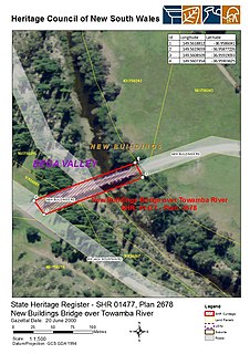
The Towamba River bridge is a heritage-listed road bridge that carries Towamba Road across the Towamba River at New Buildings in the Bega Valley Shire local government area of New South Wales, Australia. The bridge is owned by Roads and Maritime Services, an agency of the Government of New South Wales. The bridge is also called the New Buildings Bridge over Towamba River. It was added to the New South Wales State Heritage Register on 20 June 2000.
Ness is a heritage-listed natural coastal reserve at Reserve Road, Wapengo, Bega Valley Shire, New South Wales, Australia. It was added to the New South Wales State Heritage Register on 2 April 1999.

Penders is a heritage-listed holiday retreat at Haighs Road, Tanja, Bega Valley Shire, New South Wales, Australia. It was designed by Roy Grounds and built from 1964 to 1980 by Hamish Ramsay and other local builders. It is also known as Grounds and Myer Holiday Retreat, the "Barn" and Myers House. The property is owned by Office of Environment and Heritage. It was added to the New South Wales State Heritage Register on 29 November 2013.

Baronda is a heritage-listed former holiday house at Nelson Lake Road, Nelson Lagoon Mimosa Rocks National Park, Tanja, Bega Valley Shire, New South Wales, Australia. It was designed by Graeme Gunn and built from 1968 to 1969 by Kingsley Koellner (builder) and Hamish Ramsay. It is also known as Yencken House, Baronda Holiday House and Graeme Gunn-designed house. The property is owned by the NSW National Parks and Wildlife Service and the NSW Office of Environment and Heritage. It was added to the New South Wales State Heritage Register on 29 November 2013.
Greigs Flat is a locality in the Bega Valley Shire of New South Wales, Australia. At the 2016 census, Greigs Flat had a population of 151.
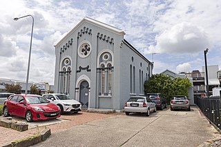
The Maitland Synagogue is a heritage-listed former synagogue located at 47 Church Street, Maitland, in the City of Maitland local government area of New South Wales, Australia. It was designed by John W. Pender and built in 1879 by James Pritchard. It is also known as The Old Synagogue. It was added to the New South Wales State Heritage Register on 2 April 1999.
Glendon Brook is a locality in the Singleton Council region of New South Wales, Australia. It has also been known as Glendonbrook. It had a population of 266 as of the 2016 census.
