Related Research Articles

Biamanga National Park is a protected area in New South Wales, Australia, 408 km (254 mi) south of Sydney and 40 km (25 mi) north of Bega. The park forms part of the Ulladulla to Merimbula Important Bird Area because of its importance for swift parrots.

Gulaga National Park is a national park on the south coast of New South Wales, Australia, about 15 kilometres (9.3 mi) south of Narooma. The park is dominated by Gulaga, also known as Mount Gulaga. The former Wallaga Lake National Park, Goura Nature Reserve, and Mount Dromedary Flora Reserve were combined to form this park in 2001. The park features the southernmost subtropical rainforest in New South Wales.

Hornsby Shire is a local government area situated on the Upper North Shore as well as parts of the Hills District, of Sydney in the state of New South Wales, Australia. The shire stretches from the M2 Hills Motorway in the south to the Hawkesbury River town of Wisemans Ferry, some 53 kilometres (33 mi) to the north, making it the largest local government council in the Greater Sydney Metropolitan region by total area. As of the 2016 census the shire had an estimated population of 142,667.

The City of Hawkesbury is a local government area of New South Wales, Australia, located on the northern and north-western fringe of the Greater Sydney area, about 50 kilometres (31 mi) north-west of the Sydney central business district. Hawkesbury City is named after the Hawkesbury River. Major towns in City of Hawkesbury are Windsor, Richmond and Pitt Town.

The Bega Valley Shire is a local government area located adjacent to the south-eastern coastline of New South Wales, Australia. The Shire was formed in 1981 with the amalgamation of the Municipality of Bega, Imlay Shire and Mumbulla Shire, with its name deriving from the town of Bega. The shire is also known as the Sapphire Coast for tourism and marketing purposes. During the 2019–20 Australian bushfire season, the area was devastated by fire, with 448 houses being destroyed by fire and approximately 365,000 hectares burned, which is 58% of the Shire's total land mass.

Richmond Valley Council (RVC) is a local government area on the Northern Rivers region of north-eastern New South Wales, Australia. RVC services an area of 3,051 square kilometres (1,178 sq mi) and draws its name from the Richmond River, which flows through most of the council area. The area under management is located adjacent to the Bruxner Highway, Pacific Highway, and the North Coast railway line.
Bega is a town in the south-east of New South Wales, Australia, in the Bega Valley Shire. It is the economic centre for the Bega Valley.

Bardwell Park is a suburb in southern Sydney, in the state of New South Wales, Australia. The suburb is located 12 kilometres south-west of the Sydney central business district and is part of the St George area. Bardwell Park is in the local government area of the Bayside Council. Bardwell Valley is a separate suburb, to the east.

Crescent Head is a town on the Mid North Coast, 340 km north-northeast of Sydney, in The Kempsey Shire local government area of New South Wales, Australia. At the 2021 census, Crescent Head had a population of 978 people. Its major industries include tourism and fishing. It has a 6-hole golf course overlooking the sea.

Tweed Shire is a local government area located in the Northern Rivers region of New South Wales, Australia. It is adjacent to the border with Queensland, where that meets the Coral Sea. Administered from the town of Murwillumbah, Tweed Shire covers an area of 1,321 square kilometres (510 sq mi), and has existed as a local government entity since 1947. It was named for the Tweed River.
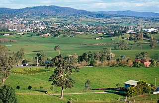
Numbugga, New South Wales, Australia, is a locality about 15 km from the town of Bega, in Bega Valley Shire, consisting of mainly farmland, rural residential dwellings and National Parks. At the 2016 census, Numbugga had a population of 125 people.

Cobargo is a village in the south-east area of the state of New South Wales in Australia in Bega Valley Shire. At the 2016 census, Cobargo had a population of 776 people. It is 386 km south of Sydney on the Princes Highway between Narooma and Bega. The town suffered heavy losses during the 2019 bushfires.
Wonboyn is a village in New South Wales, Australia in Bega Valley Shire. It is on Wonboyn Lake. At the 2021 census, Wonboyn had a population of 130.

Ballina Shire is a local government area in the Northern Rivers region of New South Wales, Australia. The Shire was formed on 1 January 1977 by the amalgamation of the Municipality of Ballina and Tintenbar Shire. The Shire is located adjacent to the Tasman Sea and the Pacific Highway. The council seat is located in the town of Ballina. The population of the Ballina Shire area was 46,850 in 2022.
Tura Beach is a suburb of Merimbula, on the South Coast of New South Wales, Australia, in the Bega Valley Shire local government area. It lies approximately 6 km north of Merimbula. At the 2016 census, Tura Beach had a population of 3,158 people with a median age of 57 years, 19 years greater than that of the overall Australian population.
Bemboka is a town in the South Coast region of New South Wales, Australia. The town is located on the Snowy Mountains Highway, in the Bega Valley Shire local government area, 474 kilometres (295 miles) south of the state capital, Sydney. At the 2021 census, the Bemboka gazetted locality had a population of 589.
South Durras is a small village on the South Coast of New South Wales, Australia. South Durras is located approximately 280 kilometres south of Sydney and 15 kilometres north of Batemans Bay, in the local government area of Eurobodalla Shire. The village is surrounded by the Murramarang National Park.

Wallaga Lake is an estuarine lake in Bega Valley Shire in New South Wales, Australia, the largest lake in southern NSW. It is located between Bermagui to the south and between Tilba Tilba to the north, situated beneath Mount Gulaga, in the traditional lands of the Yuin people. A large section of its foreshore and catchment are within the Gulaga National Park, since Wallaga Lake National Park, Goura Nature Reserve, and Mt Dromedary Flora Reserve were combined into the larger national park. There is an island in the lake known as Merriman's Island, Merriman Island or Umbarra.
Yellow Pinch Dam is a major off-stream ungated rockfill embankment dam across the Yellow Pinch Creek upstream of Merimbula in the South Coast region of New South Wales, Australia. The dam's main purpose is water supply. The impounded reservoir is also called Yellow Pinch Dam.
Congo is a village in Eurobodalla Shire on the South Coast of New South Wales. Congo is located 315 km south of Sydney, and 10 km south of Moruya.
References
- ↑ "The Bega Valley Shire". Bega Valley Shire Council. Bega Valley Shire Council. Retrieved 8 May 2016.
- ↑ Australian Bureau of Statistics (27 June 2017). "Tantawangalo". 2016 Census QuickStats. Retrieved 13 June 2018.
- ↑ "Six Mile Creek campground". NSW National Parks and Wildlife Service. NSW Government. Retrieved 8 May 2016.
| | This Australian geography article is a stub. You can help Wikipedia by expanding it. |