Daisytown is a borough in Cambria County, Pennsylvania, United States. It is part of the Johnstown, Pennsylvania Metropolitan Statistical Area. The population was 326 at the 2010 census.

Great Falls is a town in Chester County, South Carolina, United States and is located fourteen miles southwest of Lancaster, South Carolina. The population was 1,951 at the 2020 census.

Berkane is a city in northeastern Morocco, limited by the Mediterranean to the north, the Kis river and Oujda Province in the east, Nador Province to the west, and Taourirt Province in the south. It is the capital of Berkane Province.
Sefrou is one of the provinces of the Fès-Meknès region of Morocco. It had a population of 259,577 as per the Census Report of 2004.

Benslimane in a province of Morocco in the Casablanca-Settat Region. The province had a population of around 199,612 people in 2004 and covers an area of around 2,760 km².
Settat is a province of Morocco in the Casablanca-Settat Region. The province had a population of 956,904 people in 2004.

Safi Province is a province of Morocco, in the region of Marrakesh–Safi. The province takes its name from its capital Safi. Its population in 2004 is 881,007.
Ifrane is a province in the Moroccan region of Fès-Meknès. Its population in 2013 was 156,038

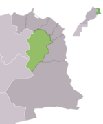
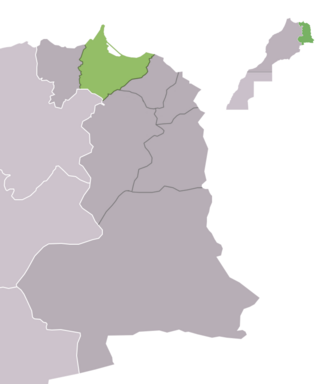
Berkane Province is located in northeastern Morocco in the Oriental region. It is bounded by the Mediterranean to its north, the Kiss Oued and Oujda Prefecture in the east, Nador Province to the west, and Taourirt Province in the south. The Berkane Province includes under its jurisdiction the towns of Saïdia and Ahfir. The population of the city is 80,012 as of the 2004 census. The population originates primarily from Aït Iznasen, a major tribe which consists of Berber clans. The tribe's descendants are spread widely over the rest of eastern Morocco, usually in cities like Ahfir, Saïdia and Oujda. The eastern dialect of Moroccan Arabic is spoken by most of the citizens, although Berber is still spoken by some of the adults.

The Figuig Province is a province in the Oriental Region of Morocco. Its capital is Bouarfa. It recorded a population of 138,325 in the 2014 Moroccan census, up from 129,430 in 2004.

Jerada is a province in the Oriental Region of Morocco. Its population in 2004 was 105,840.
Nador is a province in the Oriental Region of Morocco. Its population in 2014 was 564,943.

Ouarzazate Province is a province in the administrative region of Drâa-Tafilalet, Morocco. Its population in 2004 was 499,980.
Taroudant is a province in the Moroccan region of Souss-Massa. Its population in 2004 was 780,661.
Tiznit is a province in the Moroccan economic region of Souss-Massa. Its population in 2004 was 344,831.
Zagora is a province in the Moroccan region of Drâa-Tafilalet. Its population in 2004 was 283,368.
Es Semara is a province in the Moroccan economic region of Laâyoune-Sakia El Hamra, and the disputed territory of Western Sahara. Its population in 2004 was 60,426. Its major town is Es Semara.
El Aioun Sidi Mellouk or El Aioun is a city in Taourirt Province, Oriental, Morocco. It is located along National Route 6, 50.2 kilometres (31.2 mi) northeast of Taourirt and 58.6 kilometres (36.4 mi) southwest of Oujda. According to the 2004 census, it has a population of 34,767. It contains several schools including Lycee Ezzayotune, Ecole Mohamed Belkhayyat and Ecole Route de Jirada in the southeast of the town. College Sidi Makhoukh is located to the northeast, opposite the souk. It also has a hospital, Centre de Sante.
Mechraa Hammadi is a small town and rural commune in Taourirt Province of the Oriental region of Morocco. At the time of the 2004 census, the commune had a total population of 7435 people living in 1150 households.
Gteter is a small town and rural commune in Taourirt Province of the Oriental region of Morocco. At the time of the 2004 census, the commune had a total population of 6732 people living in 946 households.