Tarrafal is a concelho (municipality) of Cape Verde. It is situated in the northern part of the island of Santiago. Its seat is the town Tarrafal. Its population was 18,565 at the 2010 census, and its area is 120.8 km2.

Tarrafal de São Nicolau is a city in the western part of the island of São Nicolau, Cape Verde. With a population of 3,733, it is the most populous settlement of the island. It is the seat of the Tarrafal de São Nicolau Municipality, and the main port of the island. It is situated on the west coast, 9 km southwest of Ribeira Brava.

São Pedro is a village in the southwestern part of the island of Sao Vicente, Cape Verde. It is situated on the south coast, approximately 10 km southwest of the island capital Mindelo. In 2010 its population was 991. Cesária Évora Airport, the island's international airport is directly north of São Pedro. It was mentioned as a small port as "P. St. Pedro" in the 1747 map by Jacques-Nicolas Bellin. The lighthouse Farol de D. Amélia sits on the Ponta Machado, 3 km west of the village.
Picos, also known as Achada Igreja, is a city in the central part of the island of Santiago, Cape Verde. It is the seat of São Salvador do Mundo municipality. Picos is located 4 km southeast of Assomada and 23 km northwest of the capital city of Praia, near the national road from Praia to Tarrafal via Assomada (EN1-ST01).

Ribeira da Barca is a town in the municipality of Santa Catarina, on the island of Santiago, Cape Verde. In 2010 its population was 2,317. It is situated on the west coast, at the mouth of the stream Ribeira da Barca, 11 km northwest of Assomada. The settlement was mentioned as "Rivera das Baras" in the 1747 map by Jacques-Nicolas Bellin.

Ribeira da Prata is a town in the northern part of the island of Santiago, Cape Verde belonging to the municipality of Tarrafal. In 2010 its population was 1,009. It was mentioned as Rivera de Prata in the 1747 map by Jacques-Nicolas Bellin.
Achada Monte is a town in the northern part of the island of Santiago, Cape Verde and is part of the municipality of São Miguel. It is situated near the east coast, 8 km northwest of Calheta de São Miguel. In 2010 its population was 1,652. It is on the road connecting Praia and Tarrafal through Pedra Badejo, the EN1-ST02. The small bay Mangue de Sete Ribeiras is located east of the settlement. Ribeira Principal flows west of the village.
Chão Bom is a settlement in the northern part of the island of Santiago, Cape Verde. It is situated near the west coast, 3 km southeast of Tarrafal on the main road (EN1-ST01) south to Assomada and Praia. In 2010 its population was 5,166. The Tarrafal prison camp was situated north of Chão Bom. The stadium Estádio de Mangue is in the northwestern part in the communal limits. Silvino Lopes Évora, a writer, poet, journalist and a university professor is native to Chão Bom.

Palmeira is a town in the northwestern part of the island of Sal, Cape Verde. In 2010 its population was 1,420. The town is situated on the west coast, about 4 km west of the island capital Espargos. Located at Baía de Palmeira, a small bay south of the village, it is home to the main port of the island of Sal. It is the third busiest port of Cape Verde in freight traffic.

Tarrafal de Monte Trigo is a settlement in the southwestern part of the island of Santo Antão, Cape Verde. In 2010 its population was 841. It is situated on the coast, 27 km west of the island capital Porto Novo. The settlement was mentioned as Terrafal in the 1747 map by Jacques-Nicolas Bellin.
Carriçal is a settlement in the eastern part of the island of São Nicolau, Cape Verde. It is situated on the south coast, 8 km southeast of Juncalinho and 24 km east of Ribeira Brava. It is the easternmost settlement on the island. Some 8 km east is the island's easternmost point, Ponta Leste. The place was mentioned as Currissal in the 1747 map by Jacques-Nicolas Bellin.
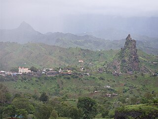
Preguiça is a settlement in the central part of the island of São Nicolau, Cape Verde. It is situated on the south coast, 6 km south of Ribeira Brava. It served as the port of Ribeira Brava, after the older Porto de Lapa, 6 km to the northeast, had been abandoned in 1653 due to pirate attacks. The settlement was mentioned as Paraghisi in the 1747 map by Jacques-Nicolas Bellin. In 1820 the Forte do Príncipe Real, now ruined, was built to protect the port. Preguiça's port consists of a stone quay and a short mole. Preguiça Airport is located 3 km north of the village.

Calheta is a town in the western part of the island of Maio. It is situated on the Atlantic coast, around 11 km north of the island capital Porto Inglês and 6 km north of Morro. Its population at the 2010 census was 1,156, making it the island's second most populous settlement. The settlement was mentioned as "Kalyete" in the 1747 map by Jacques-Nicolas Bellin.

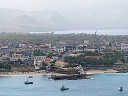
Ribeira Brava is a city on the island of São Nicolau, Cape Verde. It is the seat of the Ribeira Brava Municipality. Its population was 1,936 at the 2010 census. The town is situated in the valley of the river Ribeira Brava, east of the main mountain range of the island. The name of the river is Portuguese for "rough stream", referring to the violent behaviour of the river during rains. The city has a colonial look with Portuguese style buildings, parks and gardens, small winding streets, and steep hills.

São Domingos is a city in the central part of the island of Santiago, Cape Verde. In 2010 its population was 2,818. It is the seat of the São Domingos Municipality. It is situated 13 km southeast of Assomada and 13 km northwest of the capital Praia, along the national road from Praia to Assomada (EN1-ST01). The settlement appeared in the 1747 map by Jacques-Nicolas Bellin as St. Domingo.

Milho Branco is a village in the southeastern part of the island of Santiago, Cape Verde. It is situated 2 km north of Ribeirão Chiqueiro, 5 km east of the city São Domingos and 12 km north of the capital Praia. The national road EN1-ST02 from Ribeirão Chiqueiro to Tarrafal via Pedra Badejo passes through the village. It is part of the municipality of São Domingos. In 2010 its population was 607.
Veneza is a settlement in the northeastern part of the island of Santiago, Cape Verde. It is part of the municipality of São Miguel. It is a suburb of the city of Calheta de São Miguel, north of the city centre. It is situated on the coast, along the Praia-Pedra Badejo-Tarrafal Road (EN1-ST02). In 2010 its population was 1,375.
Ponta Verde is a seaside settlement in the northeastern part of the island of Santiago, Cape Verde. It is a suburb of the city of Calheta de São Miguel, part of the municipality of São Miguel. It is situated on the Praia-Pedra Badejo-Tarrafal Road (EN1-ST02), 1.5 km northwest of the centre of Calheta de São Miguel. In 2010 its population was 1,065.

São Martinho Grande is a settlement in the southern part of the island of Santiago, Cape Verde, and part of the municipality Ribeira Grande de Santiago. It is 4 km east from Cidade Velha and 6.5 km west of Praia city centre. National road EN1-ST05 passes north of it. 1.5 km to its south is Calheta de São Martinho, a small bay of the Atlantic Ocean. It was mentioned as "Kalyete de S. Martin" on the 1747 map by Jacques-Nicolas Bellin.
Ribeirão Chiqueiro is a village in the southcentral part of the island of Santiago, Cape Verde. It is part of the municipality of São Domingos. It is 5 km southeast of the municipal seat São Domingos. In 2010 its population was 775. Its elevation is around 270 m. The national road EN1-ST01 passes near the village.