Land and mining concession in the Matabele Kingdom
The Tati Concession was a land and mining concession created in the western borderlands of the Matabele Kingdom. The concession was originally granted by the Matabele King, Lobengula, son of Mzilikazi, to Sir John Swinburne in exchange for gold and arms. It was administered by the territory known as the Bechuanaland Protectorate after 1893, but was formally annexed to it by Proclamation Number 2 of 1911 by the High Commissioner of Bechuanaland. It was locally administered by a Justice of the Peace.
1870: Concession granted to Sir John Swinburne's London and Limpopo Mining Company.[4][5]
1880: The concession was revoked for failure to pay the annual fee, and the concession was granted instead to the Northern Light Mining Company, a syndicate formed by Danial Francis, Samuel Howard Edwards (1827–1922) and others.[4][5] The Northern Light Company was later renamed the Tati Concessions, Ltd.
1893: Tati Land was detached from Matabeleland and placed under the jurisdiction of the British Resident Commissioner of the Bechuanaland Protectorate.
21 January 1911: Annexed to Bechuanaland (now Botswana) via the Tati Concessions Land Act, with a special agreement to preserve rights of access for Rhodesian Railways (now the National Railways of Zimbabwe).[6]
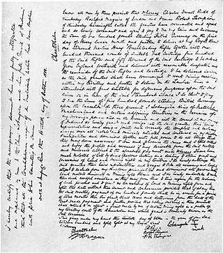
Tati Concessions Limited was formed by Sir John Swinburne after agreement was reached with Chief Lobengula, King of the Matabele, son of Mzilikaze, in which Lobengula and the Matabele received gold and arms, in exchange for rights to mine and occupy this area of land in Western Matabeleland. It was also given the right by the British Government to issue its own Revenue stamps in 1896 for use on legal instruments.[7]
The company ran into financial difficulties in 1914[8] and sold much of its land to a successor company, Tati Company Limited, originally domiciled in the United Kingdom, now in Botswana.[9]
Soon after independence, new owners of the Company agreed generous land deals with the Botswana Government under Sir Seretse Khama, in which all the undeveloped land in Francistown, and much of the Company's agricultural land was donated to Government, or sold for nominal value, for the benefit of the Batswana people, especially those with limited means. This led to bustling, modern-day Francistown. Those agreements were followed by a subsequent agreement, the acquisition by Government of the Company's mineral rights, for nominal value in 1974. All mineral rights are vested in Government, the norm throughout the country.
Southern Rhodesia was a landlocked, self-governing British Crown colony in Southern Africa, established in 1923 and consisting of British South Africa Company (BSAC) territories lying south of the Zambezi River. The region was informally known as South Zambesia until annexation by Britain, at the behest of Cecil Rhodes's British South Africa Company. The bounding territories were Bechuanaland (Botswana), Northern Rhodesia (Zambia), Portuguese Mozambique (Mozambique) and the Transvaal Republic.
The Bechuanaland Protectorate was a protectorate established on 31 March 1885 in Southern Africa by the United Kingdom. It became the Republic of Botswana on 30 September 1966.
Lobengula Khumalo was the second and last official king of the Northern Ndebele people. Both names in the Ndebele language mean "the men of the long shields", a reference to the Ndebele warriors' use of the Nguni shield.
Matabeleland is a region located in southwestern Zimbabwe that is divided into three provinces: Matabeleland North, Bulawayo, and Matabeleland South. These provinces are in the west and south-west of Zimbabwe, between the Limpopo and Zambezi rivers and are further separated from Midlands by the Shangani River in central Zimbabwe. The region is named after its inhabitants, the Ndebele people who were called "Amatabele"(people with long shields – Mzilikazi 's group of people who were escaping the Mfecani wars). Other ethnic groups who inhabit parts of Matabeleland include the Tonga, Bakalanga, Venda, Nambya, Khoisan, Xhosa, Sotho, Tswana, and Tsonga.
The British South Africa Company was chartered in 1889 following the amalgamation of Cecil Rhodes' Central Search Association and the London-based Exploring Company Ltd, which had originally competed to capitalize on the expected mineral wealth of Mashonaland but united because of common economic interests and to secure British government backing. The company received a Royal Charter modelled on that of the British East India Company. Its first directors included The 2nd Duke of Abercorn, Rhodes himself, and the South African financier Alfred Beit. Rhodes hoped BSAC would promote colonisation and economic exploitation across much of south-central Africa, as part of the "Scramble for Africa". However, his main focus was south of the Zambezi, in Mashonaland and the coastal areas to its east, from which he believed the Portuguese could be removed by payment or force, and in the Transvaal, which he hoped would return to British control.
This is a survey of the postage stamps and postal history of Bechuanaland Protectorate.
The Pioneer Column was a force raised by Cecil Rhodes and his British South Africa Company in 1890 and used in his efforts to annex the territory of Mashonaland, later part of Zimbabwe.
Francistown is the second-largest city in Botswana, with a population of about 103,417 and 147,122 inhabitants for its agglomeration at the 2022 census. It is located in eastern Botswana, about 400 kilometres (250 mi) north-northeast from the capital, Gaborone. Francistown is located at the confluence of the Tati and Ntshe rivers, and near the Shashe River and 90 kilometres (56 mi) from the international border with Zimbabwe.
The Rudd Concession, a written concession for exclusive mining rights in Matabeleland, Mashonaland and other adjoining territories in what is today Zimbabwe, was granted by King Lobengula of Matabeleland to Charles Rudd, James Rochfort Maguire and Francis Thompson, three agents acting on behalf of the South African-based politician and businessman Cecil Rhodes, on 30 October 1888. Despite Lobengula's retrospective attempts to disavow it, it proved the foundation for the royal charter granted by the United Kingdom to Rhodes's British South Africa Company in October 1889, and thereafter for the Pioneer Column's occupation of Mashonaland in 1890, which marked the beginning of white settlement, administration and development in the country that eventually became Rhodesia, named after Rhodes, in 1895.
John Smith Moffat (1835–1918) was a British missionary and imperial agent in southern Africa, the son of missionary Robert Moffat and Mary Moffat. He was the brother-in-law of missionary explorer David Livingstone. He is known for his various publications and essays detailing his journeys and experiences in Africa and the eastern Mediterranean.
Europeans first came to the region in southern Africa today called Zimbabwe in the sixteenth century, when Portuguese colonials ventured inland from Mozambique and attacked the Kingdom of Mutapa, which then controlled an area roughly equivalent to eastern Zimbabwe and western Mozambique. Portuguese influence over Mutapa endured for about two centuries before fading away during the 1690s and early-1700s (decade). During the year of 1685, French Huguenots emigrated to present-day South Africa and whilst some settled there, others moved further north into the continent. Those who did, settled within modern-day Zimbabwe, Mozambique and Botswana, and co-existed with the indigenous people; most of whom, in Zimbabwe, were the Naletale people.
This is a survey of the postage stamps and postal history of Zimbabwe.
Mthwakazi is the traditional name of the proto-Ndebele people and Ndebele kingdom and is located in between Sanyati river and Limpopo River in the area of today's Zimbabwe. Mthwakazi is widely used to refer to inhabitants of Matebeleland Province in Zimbabwe.
The Tati River is a river in northeast Botswana, a tributary of the Shashe River, which in turn is a tributary of the Limpopo River. The river flows through Francistown, where it is joined by the Ntshe River from the left.
The British South Africa Company's administration of what became Rhodesia was chartered in 1889 by Queen Victoria of the United Kingdom, and began with the Pioneer Column's march north-east to Mashonaland in 1890. Empowered by its charter to acquire, govern and develop the area north of the Transvaal in southern Africa, the Company, headed by Cecil Rhodes, raised its own armed forces and carved out a huge bloc of territory through treaties, concessions and occasional military action, most prominently overcoming the Matabele army in the First and Second Matabele Wars of the 1890s. By the turn of the century, Rhodes's Company held a vast, land-locked country, bisected by the Zambezi river. It officially named this land Rhodesia in 1895, and ran it until the early 1920s.
Bechuanaland first issued revenue stamps as Stellaland in 1884. Note: this information is wrong. Bechuanaland was split into British Bechuanaland and the Bechuanaland Protectorate. British Bechuanaland was added to the Cape Colony and the Bechuanaland Protectorate was governed from Mafeking until the seat of government was moved to Gaberone.
The Tati Goldfields are a mineral-rich band in Botswana and Zimbabwe in southern Africa. The band runs approximately 130 kilometres (81 mi) long by 5 kilometres (3 mi) wide, and crosses the Tati River. It is the southernmost of the gold-bearing bands in the Archaen greenstone (schist) belts of Zimbabwe. It is estimated that between 1866 and 1963 over 200,000 ounces of gold were produced from mines in the Tati Goldfields.
The History of Botswana includes its pre-state history, its colonial period as the Bechuanaland Protectorate, and its modern history as a sovereign state.
This page is based on this Wikipedia article Text is available under the CC BY-SA 4.0 license; additional terms may apply. Images, videos and audio are available under their respective licenses.