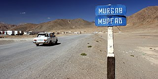
Murghob, formerly Pamirski Post is the capital of Murghob District in the Pamir Mountains of Gorno-Badakhshan Autonomous Region, Tajikistan. With a population of 4,000, Murghab is about the only significant town in the eastern half of Gorno-Badakhshan. It is the highest town in Tajikistan at 3,650 m above sea level. It is where the Pamir Highway crosses the river Murghab. Murghob is the main village of the jamoat Murghob, population 7,468 (2015).
Tursunzoda is a city in western Tajikistan, known for its aluminium smelting plant TadAZ. It is located 60 km west of Dushanbe, near the border with Uzbekistan. It is near several rivers, Shirkent and Karatag immediately to the west and east of the city, and Kofarnihon further east. Its population is estimated at 55,700 for the city proper and 298,800 for the city with the outlying communities (2020). Its population was given as 40,600 in the 1989 census, falling to 39,000 in 2000, and estimated at 37,000 in 2006.
Shamsiddin Shohin District, is a district in Khatlon Region, southeastern Tajikistan. Its capital is the village Shuroobod.

Vanj District or Nahiya-e Vanj is a district in eastern Tajikistan, in the north-west of the Gorno-Badakhshan Autonomous Region, with administrative capital Vanj.

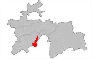
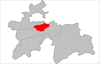
Murghob District is a district in Tajikistan, occupying the eastern two-thirds of the Gorno-Badakhshan Autonomous Region (GBAO). The area of Murghob District is 37,300 km2, covering 26 percent of Tajikistan's soil, but only 0.17% of its population. Murghob District borders on Kyrgyzstan to the north, China to the east, and Afghanistan to the south. The population of Murghob District is 15,900. Its administrative capital is the village Murghob.

Roshtqal'a District or Nohiya-i Roshtqal'a is a district in eastern Tajikistan, in the south-western part of the Gorno-Badakhshan Autonomous Region (GBAO). It stretches along the river Shakhdara between the Shughnon Range to the north and the Shakhdara Range to the south, enclosed within GBAO, without international borders. The population of Roshtqal'a district is 27,400. Its administrative capital is the village Roshtqal'a in the west part of the district, about 30 km south-east of the regional capital Khorugh.
Rushon District is a district in east Tajikistan, in the west-central part of the Gorno-Badakhshan Autonomous Region (GBAO). It stretches along the river Bartang between the Yazgulem Range to the north and the Rushon Range to the south. Its capital is Rushon, also known as Vomar, situated on the border with Afghanistan, 65 km north of Khorugh along the river Panj and the Pamir Highway. The population of Rushon district is 25,800.

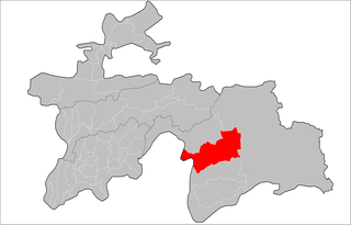
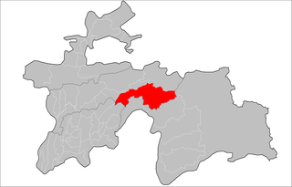
Shughnon District is a district in eastern Tajikistan, in the central-western part of Gorno-Badakhshan Autonomous Region (GBAO). It is bordered by the river Panj and Afghanistan on the west, the Rushan Range and Rushon District on the north, Murghob District on the east and the Shughnon Range and Roshtqal'a District on the south. It corresponds to the valley of the river Gunt. The district seat is the village Vahdat. The population of Shughnon District is 38,000.

Ayni District, also Aini District, is a district in the southern part of Sughd Region, Tajikistan, straddling the middle course of the river Zeravshan. Its capital is the town of Ayni, located on the Zeravshan. The population of the district is 83,600. It was named after the Tajik national poet Sadriddin Ayni. India established a base at Ayni in Tajikistan, which was used to assist the Northern Alliance during the Taliban regime.
Rasht District is a district in Tajikistan, one of the Districts of Republican Subordination. It lies between the city of Vahdat in the west and Lakhsh District in the east; its southern neighbors are Nurobod, Sangvor, and Tojikobod districts; its northern border runs along the eastern finger of Sughd Region and along the international border with Kyrgyzstan. Its capital is the town Gharm. The population of Rasht District are known as Gharmis. The population of the district is 127,400.
Sangvor District is a district of Tajikistan. It lies in the eastern part of the Districts of Republican Subordination, extending north of the Darvaz Range that forms the boundary of the Gorno-Badakhshan Autonomous Region (GBAO). Its northern boundary stretches along Rasht, Tojikobod, and Lakhsh districts. Its capital is Tavildara. The population of the district is 23,300.
Ayni is a village and jamoat in north-west Tajikistan. It is the capital of Ayni District in Sughd Region, named after the Tajik national poet Sadriddin Ayni. It lies about 177 kilometres (110 mi) from Khujand and 165 kilometres (103 mi) from Dushanbe on the bank of the river Zeravshan. The jamoat has a total population of 14,862 (2015). It consists of 11 villages, including Ayni, Chore, Khushikat, Kumarg, Zasun and Zindakon.
Anzob is a village and jamoat in north-west Tajikistan. It is located in Ayni District in Sughd Region, in the Zarafshan Range, about 110 kilometres (68 mi) north of Dushanbe. The jamoat has a total population of 8,238 (2015). It is located on the M34 highway and in the Yaghnob River valley. Anzob has a mining and beneficiation complex.

Nosiri Khusrav District, is a district located in the south-western corner of Khatlon Region of Tajikistan on the Amu Darya. It shares borders with Uzbekistan to the west, Afghanistan to the south and the Shahrtuz District to the north and east. The population of the district is 39,300. Until 2004 it was called Beshkent District ; then renamed in honor of the 11th century Persian-Tajik poet Nosiri Khusrav. The district capital is Bahori, a village at the northernmost tip of the district.
Beshkent is a lowland 70 kilometers in length and 5 kilometers in width—dry without any reliable source of water. beshkent is the warmest valley in Tajikistan, with average temperatures in January and July of 3 °C and 31 °C respectively. The annual average precipitation is 140 millimeters.
Yozghand is a village in central Tajikistan. It is part of the jamoat Tavildara in Sangvor District, one of the Districts of Republican Subordination. In 2010 Yozghand became known as the closest major village to where the Tajik National Guard Helicopter crash occurred.
Dahana is a village and a jamoat in Tajikistan, in central Asia. It is part of the city of Kulob in Khatlon Region. The jamoat has a total population of 29,776 (2015). Its administrative seat is in the village of Dahana.
Kalanak is a village and jamoat in Tajikistan. It is located in Rasht District, one of the Districts of Republican Subordination. The jamoat has a total population of 10,411 (2015). The village is on the northern, right bank of the river Surkhob. On the left bank of the river are the western foothills of the Peter I Range.
Qalaidasht is a village and jamoat in Tajikistan. It is located in Fayzobod District, one of the Districts of Republican Subordination. The jamoat has a total population of 12,074 (2015). It consists of 7 villages, including Elok.
Khumdon is a village and jamoat in central Tajikistan. It is located in Nurobod District, one of the Districts of Republican Subordination.
Peter I Range, Peter the First Range or Peter the Great Range is a mountain range in Tajikistan, part of the Pamir Mountain System. The range takes its name from Peter the Great.


