Indonesia is an archipelagic country located in Southeast Asia, lying between the Indian Ocean and the Pacific Ocean. It is located in a strategic location astride or along major sea lanes connecting East Asia, South Asia and Oceania. Indonesia is the largest archipelago in the world. Indonesia's various regional cultures have been shaped—although not specifically determined—by centuries of complex interactions with its physical environment.

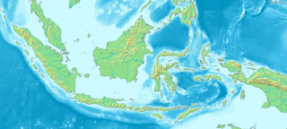
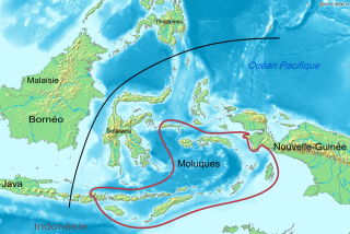
The Maluku Islands or the Moluccas are an archipelago in the east of Indonesia. Tectonically they are located on the Halmahera Plate within the Molucca Sea Collision Zone. Geographically they are located east of Sulawesi, west of New Guinea, and north and east of Timor. Lying within Wallacea, the Maluku Islands have been considered as a geographical and cultural intersection of Asia and Oceania.

The Bacan Islands, formerly also known as the Bachans, Bachians, and Batchians, are a group of islands in the Moluccas in Indonesia. They are mountainous and forested, lying south of Ternate and southwest of Halmahera. The islands are administered by the South Halmahera Regency of North Maluku Province. They formerly constituted the Sultanate of Bacan.
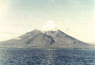
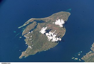
Makian, known to local people as Mount Kie Besi, is a volcanic island, one of the Maluku Islands within the province of North Maluku in Indonesia. It lies near the southern end of a chain of volcanic islands off the western coast of the province's major island, Halmahera, and lies between the islands of Moti and Tidore to the north and Kayoa and the Bacan Group to the south. The island, which forms two districts within South Halmahera Regency of North Maluku Province, covers an area of 84.36 sq.km, and had a population of 12,394 at the 2010 Census, which rose to 14,000 at the 2020 Census.

North Maluku is a province of Indonesia. It covers the northern part of the Maluku Islands, bordering the Pacific Ocean to the north, the Halmahera Sea to the east, the Molucca Sea to the west, and the Seram Sea to the south. The provincial capital is Sofifi on the largest island of Halmahera, while the largest city is the island city of Ternate. The population of North Maluku was 1,038,087 in the 2010 census, making it one of the least-populous provinces in Indonesia, but by the 2020 Census the population had risen to 1,282,937, and the official estimate as at mid 2022 was 1,319,338.
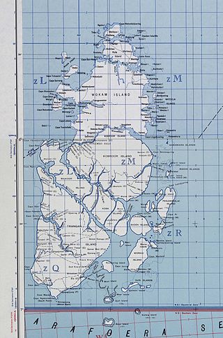
The Aru Islands Regency is a group of about 95 low-lying islands in the Maluku Islands of eastern Indonesia. It also forms a regency of Maluku Province, with a land area of 6,426.77 square kilometres. At the 2011 Census the Regency had a population of 84,138; the 2020 Census produced a total of 102,237. Some sources regard the archipelago as part of Asia, while others regard it as part of Melanesia.
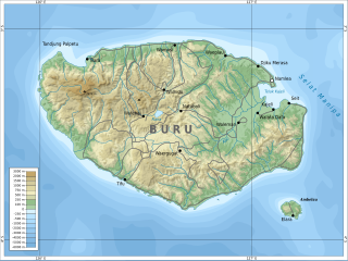
Buru is the third largest island within the Maluku Islands of Indonesia. It lies between the Banda Sea to the south and Seram Sea to the north, west of Ambon and Seram islands. The island belongs to Maluku province and includes the Buru and South Buru regencies. Their administrative centers, Namlea and Namrole, respectively, have ports and are the largest towns of the island, served by Namlea Airport and Namrole Airport.

Maluku is a province of Indonesia. It comprises the central and southern regions of the Maluku Islands. The main city and capital of Maluku province is Ambon on the small Ambon Island. The land area is 46,150.92 km2, and the total population of this province at the 2010 census was 1,533,506 people, rising to 1,848,923 at the 2020 census. The official estimate as at mid 2022 was 1,881,727. Maluku is located in Eastern Indonesia. It is directly adjacent to North Maluku, Southwest Papua, and West Papua in the north, Central Sulawesi, and Southeast Sulawesi in the west, Banda Sea, East Timor and East Nusa Tenggara in the south and Arafura Sea, Central Papua and South Papua in the east.

Tidore is a city, island, and archipelago in the Maluku Islands of eastern Indonesia, west of the larger island of Halmahera. Part of North Maluku Province, the city includes the island of Tidore together with a large part of Halmahera Island to its east. In the pre-colonial era, the Sultanate of Tidore was a major regional political and economic power, and a fierce rival of nearby Ternate, just to the north.
The Babar Islands(Indonesian: Kepulauan Babar) are located in Maluku Province, Indonesia between latitudes 7 degrees 31 minutes South to 8 degrees 13 minutes South and from longitudes 129 degrees 30 minutes East to 130 degrees 05 minutes East. The group now constitutes five districts (kecamatan) within the Maluku Barat Daya Regency of Maluku province.
The Obi Islands are a group of 42 islands in the Indonesian province of North Maluku, north of Buru and Ceram, and south of Halmahera. With a total area of 3,048.08 km2, they had a population of 41,455 at the 2010 Census and 50,760 at the 2020 Census. The official estimate as at mid 2021 was 51,510.
The Central Malayo-Polynesian languages (CMP) are a proposed branch in the Malayo-Polynesian subgroup of the Austronesian language family. The languages are spoken in the Lesser Sunda and Maluku Islands of the Banda Sea, in an area corresponding closely to the Indonesian provinces of East Nusa Tenggara and Maluku and the nation of East Timor, but with the Bima language extending to the eastern half of Sumbawa Island in the province of West Nusa Tenggara and the Sula languages of the Sula archipelago in the southwest corner of the province of North Maluku. The principal islands in this region are Sumbawa, Sumba, Flores, Timor, Buru, and Seram. The numerically most important languages are Bima, Manggarai of western Flores, Uab Meto of West Timor, and Tetum, the national language of East Timor.
The Sultanate of Ternate, previously also known as the Kingdom of Gapi is one of the oldest Muslim kingdoms in Indonesia besides Tidore, Jailolo, and Bacan. The Ternate kingdom was established by Momole Cico, the first leader of Ternate, with the title Baab Mashur Malamo, traditionally in 1257. It reached its Golden Age during the reign of Sultan Baabullah (1570–1583) and encompassed most of the eastern part of Indonesia and a part of southern Philippines. Ternate was a major producer of cloves and a regional power from the 15th to 17th centuries.
The Timoric languages are a group of Austronesian languages spoken on the islands of Timor, neighboring Wetar, and Southwest Maluku to the east.

Moluccans are the Austronesian-speaking and Papuan-speaking ethnic groups indigenous to the Maluku Islands, Indonesia. The region was historically known as the Spice Islands, and today consists of two Indonesian provinces of Maluku and North Maluku. As such, "Moluccans" is used as a blanket term for the various ethnic and linguistic groups native to the islands.

The Maluku Islands sectarian conflict was a period of ethno-political conflict along religious lines, which spanned the Indonesian islands that compose the Maluku archipelago, with particularly serious disturbances in Ambon and Halmahera islands. The duration of the conflict is generally dated from the start of the Reformasi era in early 1999 to the signing of the Malino II Accord on 13 February 2002.
Bajaw is the language of the Bajaw, widely known as the 'sea gypsies' of Maritime Southeast Asia. Differences exist between the language's varieties in western Sabah, Mapun in southern Philippines, eastern Sabah, and across Sulawesi to Maluku.

Tual is a city in Maluku Province of Indonesia located within the Kei Islands. In 2007, it was separated from the rest of the Kei Islands, which form the Southeast Maluku Regency to form an independent city.
Boano Island is an island in West Seram Regency, Maluku Province, Indonesia. It is located off the northern coast of the Hoamoal Peninsula at the western end of Seram Island, across the Boano Strait. The inhabitants speak the Boano language, Luhu, as well as Indonesian and Ambonese Malay.
