Te Urewera

Last updated

Lake Waikaremoana in Te Urewera Lake Waikaremoana, Urewera, New Zealand, 13th. Dec 2010 - Flickr - PhillipC.jpg
Lake Waikaremoana in Te Urewera

Te Urewera is an area of mostly forested, sparsely populated rugged hill country in the North Island of New Zealand, a large part of which is within a protected area designated in 2014, that was formerly Te Urewera National Park.

Contents

Te Urewera is the rohe (historical home) of Tūhoe, a Māori iwi (tribe) known for its stance on Māori sovereignty. [1]

History

The name Te Urewera is a Māori phrase meaning "The Burnt Penis" [2] (compare Māori : ure, lit. 'penis'; Māori : wera, lit. 'burnt').

Because of its isolation and dense forest, Te Urewera remained largely untouched by British colonists until the early 20th century; in the 1880s it was still in effect under Māori control. Te Kooti, a Māori leader, found refuge from his pursuers among Tūhoe, with whom he formed an alliance. As with the King Country at the time, few Pākehā risked entering Te Urewera. [1]

Between 1894 and 1912, with the approval of a Crown statute, the Urewera District Native Reserve Act 1896, leaders of Tūhoe were able to establish a traditional sanctuary known as the Urewera District Native Reserve, which had virtual home rule. However, between 1915 and 1926 the Crown mounted what has been called "a predatory purchase campaign", the Urewera Consolidation Scheme, which took some 70 percent of the reserve and relocated the Tūhoe to more than 200 small blocks of land scattered throughout what in 1954 became the Urewera National Park. [3] [4]

In the early 20th century Rua Kenana Hepetipa formed a religious community at Maungapōhatu.

In 1999, the Waitangi Tribunal published a 520-page working paper which analysed the history of the region and concluded that the Crown had never intended to allow Tūhoe self-government. [5] Between 2003 and 2005, a panel of the Waitangi Tribunal consisting of Judge Pat Savage, Joanne Morris, Tuahine Northover, and Ann Parsonson heard evidence on land claims in Te Urewera and designated an area which it called the Te Urewera inquiry district. Part One of its report, covering the period up to 1872, was published in July 2009 and found that the Crown had treated Tūhoe unfairly, especially with regard to the confiscation of a large area of land in the Eastern Bay of Plenty in 1866. [6]

Geography

The extent of Te Urewera is not formally defined. According to An Encyclopaedia of New Zealand (1966), "The Urewera Country originally included all lands east of the Rangitaiki River and west of a line along the lower Waimana River and the upper reaches of the Waioeka River. Its southern boundary was marked by Maungataniwha Mountain, the Waiau River, and Lake Waikaremoana." [7] Much of it is mountainous country, covered with native forest, and it includes the Huiarau, Ikawhenua, and Maungapohatu ranges. [7] There are a few flat mountain valleys, chiefly the Ahikereru valley, where the settlements of Minginui and Te Whaiti are, and the Ruatāhuna valley. In the north, towards Whakatāne and the coast, are lowland areas, where the settlements of Tāneatua, Ruatoki and Waimana are located. [8] Lake Waikaremoana and Lake Waikareiti are in the south-eastern part.

Most of Te Urewera is in the eastern Bay of Plenty Region and northern Hawke's Bay Region, with a small part in the Gisborne District. All the settlements are outside the protected area. The region is isolated, with State Highway 38 being the only major arterial road crossing it, running from Waiotapu near Rotorua via Murupara to Wairoa.

Status of the protected area

In 1954 much of Te Urewera was designated as the Te Urewera National Park, but that was disestablished in 2014, to be replaced by a new legal entity simply called Te Urewera. [9]

A land settlement was signed in June 2013 after being ratified by all Tūhoe members. [10] [11] Under this, Tūhoe received financial, commercial and cultural redress valued at approximately $170 million; an historical account and Crown apology; and the co-governance of Te Urewera, [12] [13] put into law by enacting the Tūhoe Claims Settlement Act 2014. [14]

The protected area is now administered by the Te Urewera Board, which comprises joint Tūhoe and Crown membership. [9] Te Urewera has legal personhood, and owns itself, [15] having in 2014 become the first natural resource in the world to be awarded the same legal rights as a person. [16] [17]

The new entity continues to meet the International Union for Conservation of Nature criteria for a Category II National Park. [18]

As of 2022, the members of the Te Urewera Board are Jim Bolger of Te Kūiti, a former prime minister of New Zealand, Maynard Manuka Apiata of Rūātoki, Lance Winitana of Waikaremoana, Marewa Titoko of Waimana, Te Tokawhakāea Tēmara of Rotorua, Tāmati Kruger of Taneatua, Dave Bamford, a sustainable tourism consultant, John Wood, previously a chief Crown negotiator, and Jo Breese, a former chief executive of World Wildlife Fund New Zealand. [19]

Flora and fauna

All North Island native-forest bird species, except for the weka, live in the area. [20] The crown fern ( Blechnum discolor ) is a widespread understory plant. [21]

See also

Related Research Articles

<span class="mw-page-title-main">Ropata Wahawaha</span> Māori chief and military leader (1820–1897)

Ropata Wahawaha was a Māori military leader and rangatira (chief) of the Ngāti Porou iwi (tribe) who rose to prominence during New Zealand's East Cape War and Te Kooti's War.

<span class="mw-page-title-main">Te Urewera National Park</span> Former National park of New Zealand

Te Urewera National Park was a national park near the east coast of New Zealand's North Island, established as such in 1954 and disestablished in 2014, when it was replaced by a new legal entity and protected area named Te Urewera. The park covered an area of approximately 2,127 km2 and was located in the north of the Hawke's Bay region of the North Island. It was the largest of four national parks in the North Island and the most isolated rainforest in the region.

<span class="mw-page-title-main">Ruatāhuna</span> Place in Bay of Plenty, New Zealand

Ruatāhuna is a small town in the remote country of Te Urewera, in the northeast of New Zealand's North Island. It is 90 kilometres directly west of Gisborne, and 18 kilometres northwest of Lake Waikaremoana. By road, it is 50 kilometres south-east of Murupara, and 110 kilometres north-west of Wairoa. It is on the upper reaches of the Whakatāne River, and surrounded on three sides by the Te Urewera protected area, formerly the Te Urewera National Park. The road that runs from Murupara through Ruatahuna to Āniwaniwa on Lake Waikaremoana, a large part of which is unsealed, used to be designated as part of State Highway 38. It is a subdivision of the Galatea-Murupara ward of the Whakatāne District.

<span class="mw-page-title-main">Lake Waikaremoana</span> Lake in the North Island of New Zealand

Lake Waikaremoana is located in Te Urewera in the North Island of New Zealand, 60 kilometres northwest of Wairoa and 80 kilometres west-southwest of Gisborne. It covers an area of 54 km2 (21 sq mi). From the Māori Waikaremoana translates as 'sea of rippling waters'.

<span class="mw-page-title-main">Ngāi Tūhoe</span> Māori iwi in New Zealand

Ngāi Tūhoe, often known simply as Tūhoe, is a Māori iwi of New Zealand. It takes its name from an ancestral figure, Tūhoe-pōtiki. Tūhoe is a Māori-language word meaning "steep" or "high noon". Tūhoe people also bear the sobriquet Nga Tamariki o te Kohu. Tūhoe traditional land is at Te Urewera in the eastern North Island, a steep, heavily forested area which includes Lake Waikaremoana. Tūhoe traditionally relied on the forest for their needs. The tribe had its main centres of population in the small mountain valleys of Ahikereru and Ruatāhuna, with Maungapohatu, the inner sanctum of the Urewera, as their sacred mountain. The Tūhoe country had a great reputation among the neighbouring tribes as a graveyard for invading forces.

<span class="mw-page-title-main">Protected areas of New Zealand</span>

Protected areas of New Zealand are areas that are in some way protected to preserve their environmental, scientific, scenic, historical, cultural or recreational value. There are about 10,000 protected areas, covering about a third of the country. The method and aims of protection vary according to the importance of the resource and whether it is publicly or privately owned.

<span class="mw-page-title-main">Tāme Iti</span> Māori activist and artist (born 1952)

Tāme Wairere Iti is a New Zealand Māori activist, artist, actor and social worker. Of Ngāi Tūhoe descent, Iti rose to prominence as a member of the protest group Ngā Tamatoa in 1970s Auckland, becoming a key figure of the Māori protest movement and the Māori renaissance. Since then, he has become a renowned activist for the rights of Māori and the process of co-governance and decolonisation.

<span class="mw-page-title-main">Tāneatua</span> Rural settlement in Bay of Plenty Region, New Zealand

Tāneatua is a small town in the Bay of Plenty region of New Zealand's North Island, 13 kilometres south of Whakatāne. State Highway 2 passes through the town on its route between Edgecumbe and Ōpōtiki. The small settlements of Ruatoki and Waimana are to the south and south-east of Tāneatua.

The Māori protest movement is a broad indigenous rights movement in New Zealand. While there was a range of conflicts between Māori and European immigrants prior to the signing of the Treaty of Waitangi in 1840, the signing provided one reason for protesting. Disagreements in the decades following the signing sometimes included war.

<span class="mw-page-title-main">Rua Kenana Hepetipa</span> Māori prophet and activist (1869–1937)

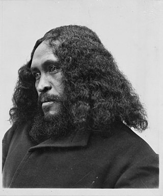
Rua Kenana Hepetipa or Rua Kēnana Hepetipa was a Māori prophet, faith healer and land rights activist. He called himself Te Mihaia Hou, the New Messiah, and claimed to be Te Kooti Arikirangi's successor Hepetipa (Hephzibah) who would reclaim Tūhoe land that had been lost to Pākehā ownership. Rua's beliefs split the Ringatū Church, which Te Kooti had founded in around 1866/1868. In 1907 Rua formed a non-violent religious community at Maungapōhatu, the sacred mountain of Ngāi Tūhoe, in the Urewera. By 1900, Maungapōhatu was one of the few areas that had not been investigated by the Native Land Court. The community, also known as New Jerusalem, included a farming co-operative and a savings bank. Many Pākehā believed the community was subversive and saw Rua as a disruptive influence.

<span class="mw-page-title-main">2007 New Zealand police raids</span> Series of armed NZ police raids in October 2007

The 2007 New Zealand police raids were a series of armed police raids conducted on 15 and 16 October 2007, in response to alleged paramilitary training camps in the Urewera mountain range near the town of Ruatoki. About 300 police, including members of the Armed Offenders Squad and Special Tactics Group, were involved in the raids, which involved the execution of search warrants at various addresses throughout New Zealand, and the establishment of roadblocks at Ruatoki and Tāneatua. The police seized four guns and 230 rounds of ammunition and arrested eighteen people. According to police, the raids were a culmination of more than a year of surveillance that uncovered and monitored the training camps.

Ruatoki North is a town in the eastern Bay of Plenty of New Zealand, just south of the small town of Tāneatua and approximately 20 km south of the city of Whakatāne. The Whakatāne River runs northwards through the Ruatoki Valley and has formed broad alluvial flats. The main settlement of Ruatoki North is on the eastern side of the river.

Te Wharekura o Ruatoki is a rural school in the Māori settlement of Ruatoki in the Eastern Bay of Plenty region, New Zealand, serving children in years 1 through 13. It was established as Ruatoki Native School in 1896 after a visit by Richard Seddon and James Carroll. In 1978 it became New Zealand’s first officially bilingual school.

Te Hui Ahurei a Tūhoe is a festival that was created in 1971 by John Rangihau for the Iwi nation Ngāi Tūhoe. Kapa haka teams that come from the Iwi nation perform and Tūhoe people gather to celebrate.

<span class="mw-page-title-main">Pou Temara</span> New Zealand Māori academic (born 1948)

Sir William Te Rangiua "Pou" Temara is a New Zealand academic. He is professor of Māori language and tikanga Māori (practices) at Waikato University and a cultural authority on whaikōrero (oratory), whakapapa (genealogy) and karakia. Prior to working at Waikato, he taught at Victoria University of Wellington, where he also studied, and at Te Whare Wānanga o Awanuiārangi.

Waimana is a rural valley in the Whakatāne District and Bay of Plenty Region of New Zealand's North Island. It is located in the northern Te Urewera. Waimana River, originally known as Tauranga River, runs through the valley, joining the Ohinemataroa River one kilometre south-west of Tāneatua.

Matahi is a rural valley in the Whakatāne District and Bay of Plenty Region of New Zealand's North Island.

<span class="mw-page-title-main">Whakatōhea</span> Māori iwi in New Zealand

Te Whakatōhea is a Māori iwi of the eastern Bay of Plenty region of New Zealand. Their traditional territory extends along the coastline eastwards from Ōhiwa Harbour to Opape, and inland to Mātāwai, and is centred in the area around the town of Ōpōtiki. These lands have long held an abundance of food resources, particularly seafood. All their historical pā were situated near the coast, to defend the marine resources.

Maungapohatu is a settlement in the Bay of Plenty Region of New Zealand's North Island. Located in a remote area of the Urewera bush country about 20 kilometres (12 mi) north of Lake Waikaremoana, it was founded by Rua Tapunui Kenana in 1907 and was substantially rebuilt twice during the next two decades. At its peak more than 500 people lived there but today it is once more a very sparsely populated place.

<span class="mw-page-title-main">Rua Kēnana Pardon Act 2019</span> Act of Parliament in New Zealand

The Rua Kēnana Pardon Act 2019 is a statute in the New Zealand Parliament that provides a pardon for the Tūhoe prophet Rua Kēnana (1869–1937).

References

  1. 1 2 King, Michael (2003). The Penguin History of New Zealand. Penguin Books. ISBN   0-14-301867-1.
  2. Binney, Judith (2009). "1". Encircled lands : Te Urewera, 1820–1921. Wellington, N.Z.: Bridget Williams Books. p. 21. ISBN   9781877242441 . Retrieved 22 June 2018. Tūhoe are guardians of the lands they named 'Te Urewera', the Burnt Penis. Its fearsome name depicts the fate of Mura-kareke, a son of Tuhoe-potiki, the eponymous ancestor. One version narrates that Mura-kareke chose this death in protest at his sons' treatment of their youngest brother, his 'favourite' child. A different and grimmer version tells that Mura-kareke burnt the severed penis of his younger brother, Mura-anini, in a cooking fire. This was his revenge for Mura-anini's adultery with Mura-kareke's wife. Both versions – one stoic, one savagely vengeful – recall family lines in conflict.
  3. Webster, Steven, "Ōhaua Te Rangi and reconciliation in Te Urewera, 1913–1983", Journal of the Polynesian Society Vol. 128, No. 2, June 2019, at thepolynesiansociety.org, accessed 19 July 2022
  4. "Urewera District Native Reserve Act 1896 (60 Victoriae 1896 No 27)", nzlii.org, accessed 19 July 2022
  5. Anita Miles, "Te Urewera", waitangitribunal.govt.nz, accessed 19 July 2022
  6. Te Manutukutuku Issue 63, July 2009, accessed 19 July 2022
  7. 1 2 McLintock, A.H., ed. (1966). "Urewera". An Encyclopaedia of New Zealand.
  8. McKinnon, Malcolm (23 March 2015). "Bay of Plenty places – Urewera lowland settlements". Te Ara – the Encyclopedia of New Zealand.
  9. 1 2 Ruru, Jacinta (October 2014). "Tūhoe-Crown settlement – Te Urewera Act 2014". Māori Law Review: 16–21. Retrieved 13 December 2015.
  10. "Crown and Ngāi Tuhoe sign deed of settlement", 4 June 2013, The Beehive
  11. "Govt and Tuhoe sign $170m settlement". 3 News NZ. 22 March 2013. Archived from the original on 2 June 2013. Retrieved 22 March 2013.
  12. "Crown offer to settle the historical claims of Ngāi Tūhoe"
  13. "Tuhoe's plans for $170M settlement". 3 News NZ. 20 March 2013. Archived from the original on 13 April 2013.
  14. "Tūhoe-Crown settlement – Tūhoe Claims Settlement Act 2014; Te Urewera report of the Waitangi Tribunal", October 2014 Māori Law Review
  15. Te Urewera Act 2014, ss 11–12.
  16. Gibson, Jacqui (9 June 2020). "The Māori tribe protecting New Zealand's sacred rainforest". BBC Travel. Retrieved 29 September 2021.
  17. BBC's The Travel Show (29 September 2021). "Te Urewera: New Zealand's 'living' rainforest". BBC Travel. Retrieved 29 September 2021.
  18. "Tūhoe Claims Settlement and Te Urewera bills passed". Scoop. 24 July 2014. Retrieved 13 December 2015.
  19. "Meet the Board", ngaituhoe.iwi.nz, accessed 19 July 2022
  20. "Te Urewera National Park". Department of Conservation. Retrieved 26 March 2012.
  21. Hogan, C. Michael. "Crown Fern Blechnum discolor". iGoTerra. Retrieved 13 October 2014.

38°45′0″S177°9′0″E / 38.75000°S 177.15000°E / -38.75000; 177.15000