
Fiordland is a geographical region of New Zealand in the south-western corner of the South Island, comprising the westernmost third of Southland. Most of Fiordland is dominated by the steep sides of the snow-capped Southern Alps, deep lakes, and its steep, glacier-carved and now ocean-flooded western valleys. The name "Fiordland" comes from a variant spelling of the Scandinavian word for this type of steep valley, "fjord". The area of Fiordland is dominated by, and very roughly coterminous with, Fiordland National Park, New Zealand's largest National Park.

Kaikōura is a town on the east coast of the South Island of New Zealand, located on State Highway 1, 180 km north of Christchurch. The town has an estimated permanent resident population of 2,360. Kaikōura is the seat of the territorial authority of the Kaikōura District, which is part of the Canterbury region.

Hector's dolphin is one of four dolphin species belonging to the genus Cephalorhynchus. Hector's dolphin is the only cetacean endemic to New Zealand, and comprises two subspecies: C. h. hectori, the more numerous subspecies, also referred to as South Island Hector's dolphin; and the critically endangered Māui dolphin, found off the West Coast of the North Island.

The Otago Peninsula is a long, hilly indented finger of land that forms the easternmost part of Dunedin, New Zealand. Volcanic in origin, it forms one wall of the eroded valley that now forms Otago Harbour. The peninsula lies south-east of Otago Harbour and runs parallel to the mainland for 20 km, with a maximum width of 9 km. It is joined to the mainland at the south-west end by a narrow isthmus about 1.5 km wide.

Otago Harbour is the natural harbour of Dunedin, New Zealand, consisting of a long, much-indented stretch of generally navigable water separating the Otago Peninsula from the mainland. They join at its southwest end, 21 km (13 mi) from the harbour mouth. It is home to Dunedin's two port facilities, Port Chalmers and at Dunedin's wharf. The harbour has been of significant economic importance for approximately 700 years, as a sheltered harbour and fishery, then deep water port.
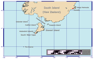
Foveaux Strait is a strait that separates Stewart Island from the South Island of New Zealand. The width of the strait ranges from about 23 to 53 km and the depth varies between 18 and 46 m. Captain James Cook passed around the southern tip of Stewart Island during his circumnavigation of the South Island in 1770 but did not record the presence of a seaway between Stewart Island and the mainland. The strait was not charted until 1804 when an American sealer, Owen Folger Smith, mapped it.
Chalky Island or Te Kākahu-o-Tamatea is an island in the southwest of New Zealand, and is part of Fiordland National Park. It lies at the entrance to Taiari / Chalky Inlet, next to Rakituma / Preservation Inlet, at the southwestern tip of the South Island, 10 kilometres (6 mi) northwest of Puysegur Point, 15 kilometres (9 mi) southeast of West Cape, and 140 kilometres (87 mi) west of Invercargill. Chalky Island is one of the predator-free islands that is part of the Fiordland Islands restoration programme. The programme's focus is to eradicate pests and translocate native species.

Taiaroa Head is a headland at the end of the Otago Peninsula in New Zealand, overlooking the mouth of the Otago Harbour. It lies within the city limits of Dunedin. The nearest settlement, Otakou, lies three kilometres to the south.
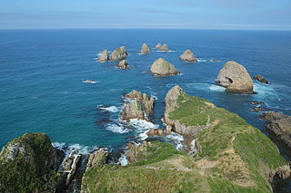
Nugget Point is one of the most iconic landforms on the Otago coast in New Zealand. Located at the northern end of the Catlins coast, along the road from Kaka Point, this steep headland has a lighthouse at its tip, surrounded by rocky islets. The point is home to many seabirds, including penguins, gannets and royal spoonbills, and a large breeding colony of fur seals. Roaring Bay, on the south coast of the tip of Nugget Point, is home to a small colony of yellow-eyed penguins.

Porpoise Bay is in the Catlins, on the southern coast of New Zealand's South Island. The bay sweeps gently from North Head, at the entrance to Waikawa Harbour, around to South Head. A campground overlooking the bay is situated on South Head, which separates Porpoise Bay from Curio Bay.
Orepuki in Southland, New Zealand is a small country township on the coast of Te Waewae Bay some 20 minutes from Riverton, 15 minutes from Tuatapere and 50 minutes from Invercargill that sits at the foot of the Longwood Range. Once a thriving gold mining settlement of 3000 people, today Orepuki is something of a ghost town with an assortment of abandoned stores, goldmining relics and sluicing scars as the only reminders of its former glory.

The Hump Ridge Track, also called the Tuatapere Hump Ridge Track, is a 61 km walking track that is partly in Fiordland National Park in New Zealand. The track was opened in 2001 and is run privately on behalf of the Tuatapere Hump Ridge Track Charitable Trust.
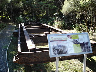
Port Craig is located along the south coast of the South Island New Zealand near Tuatapere. It was a small logging town born in 1916, with 200+ men women and children living there in its prime. Like other New Zealand bush towns, Port Craig was inhabited by hardy kiwi bushmen and their families, recent immigrants and a few others trying to keep clear of the law. The Marlborough Timber Company had a large scale plan to log one of the countries last significant coastal forests. The company planned big, they built the Dominion's largest sawmill, an extensive tramway system, port facilities and township all without road access. The bush was worked by the Lidgerwood overhead logging cable system (gantry) that weighed over 50 tonnes. The immense size of the gantry meant that it was very difficult to relocate in the inhospitable forest and after one major shift, the gantry was left redundant, crippling the local logging industry.

The Southern Scenic Route is a tourist highway in New Zealand linking Queenstown, Fiordland, Te Anau and the iconic Milford Road to Dunedin via, Riverton, Invercargill and The Catlins. An Australian travel magazine labelled it "one of the world's great undiscovered drives" in 2008.

Rakituma / Preservation Inlet is the southernmost fiord in Fiordland National Park and lies on the southwest corner of the South Island of New Zealand. With an area of 93 square kilometres (36 sq mi), it is the fourth largest fiord in New Zealand, after Tamatea / Dusky Sound, Doubtful Sound / Patea, and the neighbouring Taiari / Chalky Inlet to the north. Rakituma was briefly the site of an attempted fishing and gold mining settlement at Cromarty during the 19th century, however this was quickly abandoned once the level of gold declined in relation to more promising fields elsewhere.

Māui dolphin, Maui's dolphin, or Popoto is a subspecies of the Hector's dolphin —New Zealand's only endemic cetacean. Māui dolphins are only found off the west coast of New Zealand's North Island, and are now one of the rarest and smallest dolphin subspecies globally. A 2021 report issued by the New Zealand government suggests the population rests at 54 individuals, but when taking into account recent mortalities, the population could sit at fewer than 40 individuals. Both the Māui dolphin and South Island Hector's dolphin are threatened by commercial fisheries, including set-netting and trawling, recreational netting, and disease including toxoplasmosis and brucellosis. Low food availability may also be an issue for Māui dolphins, which may increase their susceptibility to climate change.
The Open Bay Islands are located in South Westland, off the south-west coast of the South Island of New Zealand. They consist of two main islands, Taumaki and Popotai, plus several smaller islets and rocks. They lie approximately 5 km (3.1 mi) offshore from the Okuru River mouth, near Haast, and are owned by the West Coast branch Māori iwi Ngāi Tahu known as Poutini Ngāi Tahu.

Whale watching in New Zealand is predominantly centred around the areas of Kaikōura and the Hauraki Gulf. Known as the 'whale capital', Kaikōura is a world-famous whale watching site, in particular for sperm whales which is currently the most abundant of large whales in New Zealand waters. The Hauraki Gulf Marine Park is also a significant whale watching area with a resident population of Bryde's Whales commonly viewed alongside other cetaceans Common Dolphins, Bottlenose Dolphins and Orca. Whale watching is also offered in other locations, often as eco-tours and in conjunction with dolphin watching. Land-based whale watching from New Zealand's last whaling station, which closed in 1964, is undertaken for scientific purposes, mostly by ex-whalers.
Piopiotahi Marine Reserve is a marine reserve covering an area of 690 hectares in the Milford Sound / Piopiotahi, in Fiordland on New Zealand's South Island. It was established in 1993 and is administered by the Department of Conservation.


