Related Research Articles
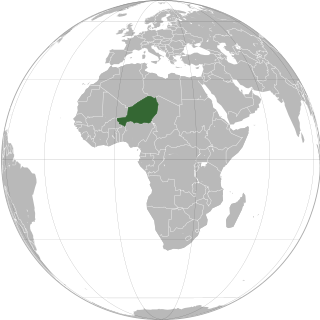
Niger or the Niger, officially the Republic of the Niger, is a landlocked country in West Africa. It is a unitary state bordered by Libya to the northeast, Chad to the east, Nigeria to the south, Benin and Burkina Faso to the southwest, Mali to the west, and Algeria to the northwest. It covers a land area of almost 1,270,000 km2 (490,000 sq mi), making it the largest landlocked country in West Africa and the second largest landlocked nation in Africa behind Chad. Over 80% of its land area lies in the Sahara. Its predominantly Muslim population of about 25 million lives mostly in clusters in the south and west of the country. The capital Niamey is located in Niger's southwest corner.

Zinder, formerly also spelled Sinder, is the third largest city in Niger, with a population of 235,605 as by the 2012 census. It is situated 861 km (535 mi) east of the capital Niamey and 240 km (150 mi) north of the Nigerian city of Kano.
Diffa is a city and Urban Commune in the extreme southeast of Niger, near the border with Nigeria. It is the administrative seat of both Diffa Region, and the smaller Diffa Department. As of 2012, the commune had a total population of 56,437 people.

Dosso is a city in the south-west corner of Niger. It lies 130–140 kilometres (81–87 mi) south-east of the capital Niamey at the junction of the main routes to Zinder and Benin. The eighth-most populous town in Niger and the largest in Dosso Region, it had an official population during the 2001 census of 43,561. The population grew to 58,671 in the 2012 census. It is the capital of its region - which covers five departments in the southwestern corner of the nation - as well as of its own department, Dosso Department. The city itself lies at the centre of its own Urban Commune.
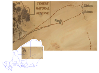
Bilma is an oasis town and commune in north east Niger with, as of the 2012 census, a total population of 4,016 people. It lies protected from the desert dunes under the Kaouar Cliffs and is the largest town along the Kaouar escarpment. It is known for its gardens, for salt and natron production through evaporation ponds, date cultivation, and as the destination of one of the last Saharan caravan routes.
Birni-N'Konni is a town in the Tahoua Region of Niger, lying immediately north of the border of Nigeria and west of seasonal Maggia River. It is an important market town and transport hub and as of the 2012 census had a population of 63,169. The town is the historic centre of the small pre-colonial Hausa state of Konni. The name comes from the Hausa for "Walled Town of Konni", and many Hausa towns designate the old citadel neighbourhood the "Birni".

Maradi is the second largest city in Niger and the administrative centre of Maradi Region. It is also the seat of the Maradi Department and an Urban Commune.

Madaoua is a town and urban commune located in the Tahoua Region of Niger. It has a population of 127,254. It is seat of the Madaoua Department, forming the southwest corner of the Region, and is an Urban Commune.

Dongondoutchi is a commune in Niger. It is located about 300 km east of the capital Niamey and 40 km from the Nigerian border. It lies on national route 1 which links the capital to the towns of Maradi and Zinder to the east and the RN25 heading to north to Tahoua, Agadez and Arlit.
In-Gall is a department, commune and town in the Agadez Region of northeast Niger, with a year-round population of less than 500. Known for its oasis and salt flats, In-Gall is the gathering point for the Cure Salee festival of Tuareg and Wodaabe pastoralists to celebrate the end of the rainy season each September. During the festival, In-Gall's population grows to several thousand nomads, officials, and tourists. As of 2011, the commune had a total population of 47,170 people.
Say (Saayi) is a town in southwest Niger, situated on the Niger River. It is the capital of the Say Department in the Tillabéri Region. Say was a small Songhai town prior to the arrival of the Fulani marabout Alfa Mohamed Diobo in the nineteenth century who converted the town to a center for Islamic learning and established the Emirate of Say. The municipality has 58,290 inhabitants, and its economy is dominated by agriculture, herding and small trade. Today, the inhabitants of Say are mostly Peulh, Songhai and Zarma.
Fachi is an oasis surrounded by the Ténéré desert and the dunes of the Erg of Bilma in eastern Niger, placed on the western edge of the small Agram mountain outcropping. It has a population of 2,215 people (2012). It is also a stopping point of the Agadez to the Kaouar caravans of the Azalay. Fachi is 240 kilometres west of Bilma and 320 km (200 mi) east of the Aïr Mountains. Apart from water, dates, and salt, Fachi produces no provisions, and depends entirely upon trade in these products with passing caravans.
The Arma people are an ethnic group of the middle Niger River valley, descended from Moroccan invaders of the 16th century. The name, applied by other groups, derives from the word ar-rumah "fusiliers".
The Kaocen revolt was a Tuareg rebellion against French colonial rule of the area around the Aïr Mountains of northern Niger during 1916–17.
Dirkou is a town in the Bilma Department, Agadez Region of north-eastern Niger. It lies in the northern Kaouar escarpment, a north–south line of cliffs which form an isolated oasis in the Sahara desert. As of 2011, the commune had a total population of 14,998 people. Apart from the main city of Dirkou, the rural communities of Achénouma, Aney, and Emi Tchouma lie within the borders of the commune.
Kokorou or Kokoro is a town and rural commune in the Téra Department of western Niger. As of 2012, it had a population of 96,218, living in rural towns and villages.
Tamou is a village and "Rural commune" in Niger. The town is capital of its Rural Commune in the Say Department of Tillabéri Region, in the far southwest of the nation. It is southwest of Niamey, on the right (western) bank of the Niger River, between the departmental capital Say and the border of Burkina Faso. Tamou Commune is home to the Tamou Total Reserve, a wildlife reserve which is part of the larger W National Park and Transborder Reserve. The Tamou Reserve, in which local people also live, is primarily dedicated to the protection of African Elephant populations which migrate through the region.

Tesker or Tasker is a village and rural commune in Niger. As of 2012, it had a population of 37,132 people. It is the birthplace of musician Mamane Barka . The sparsely populated commune extends over a wide area and spans two major regions: the Sahel region in the south and the Sahara desert in the north. In the northeast, it rises up to a height of 710 metres (2,330 ft) at the Termit Massif. It is bordered by Fachi and Tabelot in the north, N'Gourti to the east, Alakoss, Kellé and N'Guelbély to the south and Tenhya to the west. The municipality is divided into 36 administrative villages, one traditional village, three hamlets, 29 camps and 144 watering places.

The 2015 Niger raid was an unsuccessful assault on the Nigerien towns Bosso and Diffa, perpetrated by Boko Haram. The incident occurred on 6 February 2015, marking the first major Boko Haram incursion into Niger.

Since 2015, the border area between Burkina Faso, Mali, and Niger has been a hotbed for jihadist forces originating from Mali. The insurgency has taken place in two distinct regions of Niger. In southwest, the Islamic State in the Greater Sahara and the Nusrat al-Islam have carried out attacks in the tri-border area with Burkina Faso and Mali. Meanwhile, in the southeast, the Islamic State in the West African Province has established control in parts of southern Niger.
References
- ↑ Teguidda-n-Tessoumt, Niger Page [ dead link ]. Falling Rain Genomics, Inc. 1996-2004
- Decalo, Samuel (1997). Historical Dictionary of the Niger (3rd ed.). Boston & Folkestone: Scarecrow Press. ISBN 0-8108-3136-8.
- Geels, Jolijn (2006). Niger. Chalfont St Peter, Bucks / Guilford, CT: Bradt UK / Globe Pequot Press. ISBN 978-1-84162-152-4.
17°25′44.68″N6°38′35.51″E / 17.4290778°N 6.6431972°E
| International | |
|---|---|
| National | |
| | This Niger location article is a stub. You can help Wikipedia by expanding it. |