
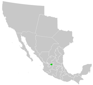
The Tehuantepec Territory (Spanish : Territorio de Tehuantepec) was a federal territory of Mexico in the Isthmus of Tehuantepec. It existed between 1853 and 1857.[ citation needed ]
The Tehuantepec Territory (Spanish : Territorio de Tehuantepec) was a federal territory of Mexico in the Isthmus of Tehuantepec. It existed between 1853 and 1857.[ citation needed ]
On 29 May 1853, the territory was established by president Antonio López de Santa Anna, at request of Gregorio Meléndez ("Che Gorio Melendre"), a local ruler of the town of Juchitán who assisted Santa Anna in his seizure of power. The states of Oaxaca and Veracruz ceded area for the formation of the territory. The port of Minatitlán located in the Gulf of Mexico was the capital. Santa Anna hoped to construct a railroad or canal on the isthmus, though this plan was proven to be unfeasible. [1]
With the proclamation of the Constitution of 1857, two years after the fall of Santa Anna, the territory was dissolved and reintegrated into its predecessor states. [2] [3]

The United Mexican States is a federal republic composed of 32 federal entities: 31 states and Mexico City, an autonomous entity. According to the Constitution of 1917, the states of the federation are free and sovereign in all matters concerning their internal affairs. Each state has its own congress and constitution.
The Gadsden Purchase is a 29,640-square-mile (76,800 km2) region of present-day southern Arizona and southwestern New Mexico that the United States acquired from Mexico by the Treaty of Mesilla, which took effect on June 8, 1854. The purchase included lands south of the Gila River and west of the Rio Grande where the U.S. wanted to build a transcontinental railroad along a deep southern route, which the Southern Pacific Railroad later completed in 1881–1883. The purchase also aimed to resolve other border issues.

Oaxaca, officially the Free and Sovereign State of Oaxaca, is one of the 32 states that compose the Federative Entities of the Mexico. It is divided into 570 municipalities, of which 418 are governed by the system of usos y costumbres with recognized local forms of self-governance. Its capital city is Oaxaca de Juárez.

Departments of Colombia refer to the administrative divisions of Colombia. As of 2024, the unitary republic is made up of thirty-two departments. Each department has a governor and an assembly, elected by popular vote for a four-year period.

The Isthmus of Tehuantepec is an isthmus in Mexico. It represents the shortest distance between the Gulf of Mexico and the Pacific Ocean. Before the opening of the Panama Canal, it was a major overland transport route known simply as the Tehuantepec Route. The name is taken from the town of Santo Domingo Tehuantepec in the state of Oaxaca; this was derived from the Nahuatl term Tēcuāntepēc.

Tehuantepec is a city and municipality in the southeast of the Mexican state of Oaxaca. It is part of the Tehuantepec District in the west of the Istmo Region. The area was important in pre-Hispanic period as part of a trade route that connected Central America with what is now the center of Mexico. Later it became a secondary capital of the Zapotec dominion, before it was conquered by the Spanish in the early 16th century.

Juchitán de Zaragoza is an indigenous town in the southeast of the Mexican state of Oaxaca. It is part of the Juchitán District in the west of the Istmo de Tehuantepec region. With a 2020 census population of 88,280, it is the third-largest city in the state. The majority of the indigenous inhabitants are Zapotecs and Huaves. The town also serves as the municipal seat for the surrounding municipality, with which it shares a name. The municipality has an area of 414.64 km2 and a population of 113,570, the state's third-largest in population.

Salina Cruz is a major seaport on the Pacific coast of the Mexican state of Oaxaca. It is the state's fourth-largest city and is the municipal seat of the municipality of the same name. It is part of the Tehuantepec District in the west of the Istmo Region. The city had a 2020 census population of 76,660, while its municipality, with an area of 131.9 km2 (50.9 sq mi) had a population of 84,438, the state's fifth-largest municipality in population.

In Zapotec cultures of Oaxaca, a muxe is a person assigned male at birth who dresses and behaves in ways otherwise associated with women; they may be seen as a third gender.
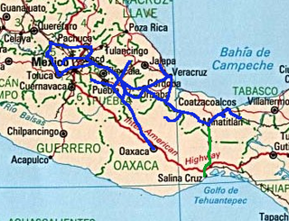
The Ferrocarril del Istmo de Tehuantepec(Ferrocarril del Istmo de Tehuantepec, S.A. de C.V.), also known as Tren Interoceánico, Line Z, Ferrocarril Transístmico or simply Ferroistmo, is part of the Interoceanic Corridor of the Isthmus of Tehuantepec, owned by the Mexican government, that crosses the Isthmus of Tehuantepec between Puerto Mexico, Veracruz, and Salina Cruz, Oaxaca. It is leased to Ferrocarril del Sureste FERROSUR.
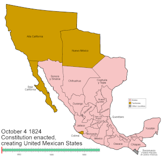
Mexico has experienced many changes in territorial organization during its history as an independent state. The territorial boundaries of Mexico were affected by presidential and imperial decrees. One such decree was the Law of Bases for the Convocation of the Constituent Congress to the Constitutive Act of the Mexican Federation, which determined the national land area as the result of integration of the jurisdictions that corresponded to New Spain, the Captaincy General of Yucatán, the Captaincy General of Guatemala and the autonomous Kingdoms of East and West. The decree resulted in the independence from Spain.
Events in the year 1829 in Mexico.

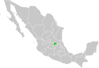
Istmo de Tehuantepec is the largest region of the state of Oaxaca, located in southwestern Mexico.
Juchitán District is located in the east of the Istmo de Tehuantepec region of the State of Oaxaca, Mexico, covering the southern part of a low-lying corridor through the mountains that separates the Gulf of Mexico from the Pacific Ocean. The district has an area of 13,300 km2 and a population as of 2005 of 339,445.
The Second Federal Republic of Mexico refers to the period of Mexican history involving a second attempt to establish a federal government in Mexico after the fall of the unitary Centralist Republic of Mexico in 1846 at the start of the Mexican-American War. It would last up until the Second French Intervention in Mexico led to the proclamation of the Second Mexican Empire in 1863.
"La Sandunga" is a traditional Mexican waltz and the unofficial anthem of the Isthmus of Tehuantepec, in the state of Oaxaca. It is inspired by the Spanish jota style of music and also contains Native American and Mestizo elements. Sandunga is a rarely used word in the Spanish language that can be translated in a variety of ways including; gracefulness, elegance, charm, wit, and celebration. The melody of the song is believed to have originated from Andalusia and it was rearranged by Zapotec musician Andres Gutierrez . The lyrics were written by Máximo Ramó Ortiz in 1853 after the death of his mother. Ortiz, who served as governor of Tehuantepec also wrote the song in part to promote independence of the isthmus from the Mexican government. The song tells of a Zapotec woman mourning the death of her mother while crying out, "Sandunga".
Aguascalientes was a federal territory of Mexico, lasting from 1835 and 1857.
Federal Highway 190D is the tolled Federal Highway that parallels Federal Highway 190. Highways with the 190D signage are in the states of Oaxaca and Chiapas.
The Sierra Gorda Territory was a federal territory of Mexico. It existed between 1853 and 1857.

The Interoceanic Corridor of the Isthmus of Tehuantepec, abbreviated as CIIT, is a trade and transit route in Southern Mexico, under the control of the Mexican Secretariat of the Navy, which connects the Pacific and Atlantic Oceans through a railway system, the Ferrocarril del Istmo de Tehuantepec, for both cargo and passengers, crossing through the Isthmus of Tehuantepec. This project also consists on the modernization and growth of local seaports, particularly the ports of Salina Cruz (Oaxaca) and Coatzacoalcos (Veracruz), and of the Minatitlán oil refinery and the Salina Cruz oil refinery. In addition, it plans to attract private investors through the creation of 10 industrial parks in the Isthmus area, as well as two other parks in Chiapas. The project has the goal of developing the economy and industry of the Mexican South through encouraging economic investment, both national and international, and facilitate commerce and transportation of goods internationally.
{{cite book}}: |website= ignored (help)