Related Research Articles

The Marshall Islands, officially the Republic of the Marshall Islands, is an independent island country near the Equator in the Pacific Ocean, slightly west of the International Date Line. Geographically, the country is part of the larger island group of Micronesia. The country's population of 58,413 people is spread out over five islands and 29 coral atolls, comprising 1,156 individual islands and islets. The capital and largest city is Majuro. It has the largest portion of its territory composed of water of any sovereign state, at 97.87%. The islands share maritime boundaries with Wake Island to the north, Kiribati to the southeast, Nauru to the south, and Federated States of Micronesia to the west. About 52.3% of Marshall Islanders live on Majuro. In 2016, 73.3% of the population were defined as being "urban". The UN also indicates a population density of 760 inhabitants per square mile (295/km2), and its projected 2020 population is 59,190.

This article is about communications systems in the Marshall Islands.
South Island is a national park in North Queensland (Australia), 692 km northwest of Brisbane and the island is part of the Lizard Island Group and is South of Lizard Island situated 270 km north of Cairns, Queensland.
The flag of the Marshall Islands, an island nation in the Pacific, was adopted upon the start of self-government, May 1, 1979. The flag was designed by Emlain Kabua, who served as the first First Lady of the republic.
Toribio Alonso de Salazar, born in Biscay, was a Spanish navigator of Basque origin, who was the first Westerner to arrive on the Marshall Islands on August 21, 1526.
The music of the Marshall Islands has a long history. The Marshall Islands are an independent island chain, geographically and culturally part of the Micronesian area. It was part of the Trust Territory of the Pacific Islands, governed by the United States, until independence in 1986.

.mh is the Internet country code top-level domain (ccTLD) for the Marshall Islands. Its registry website has been inactive since the end of 2021, and prior to that had not been updated since 1997. The mechanism of registering domains listed on that site involved downloading an InterNIC template form that had been a dead link for at least several years. As of 2021, a search shows three active websites using a .mh domain: one for the government's Natural Disaster Management Office, one for the school system, and one for a telecommunications company. The latter has two separate .mh domains, though both serve the same website.
Elections in Marshall Islands gives information on election and election results in Marshall Islands.
Iroijlaplap are the traditional paramount chiefs in the Marshall Islands. Ordinary chiefs bear the title of Iroij ; -ļapļap is a superlative suffix.

Wellow is a village on the Isle of Wight. It is located about two miles east of Yarmouth in the northwest of the island. The name is believed to be of Jutish origin. Recently a proposal to erect a wind farm was rejected after a high-profile protest campaign. Located within Wellow are a small chapel, post office, vineyard and several farms including Mattingley and Manor Farm. The Hamstead trail runs through Wellow.
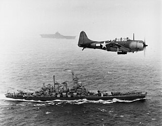
The Gilbert and Marshall Islands campaign were a series of battles fought from August 1942 through February 1944, in the Pacific theatre of World War II between the United States and Japan. They were the first steps of the drive across the central Pacific by the United States Pacific Fleet and Marine Corps. The purpose was to establish airfields and naval bases that would allow air and naval support for upcoming operations across the Central Pacific. Operation Galvanic and Operation Kourbash were the code names for the Gilberts campaign that included the seizures of Tarawa and Makin, during the Battle of Tarawa of 20–23 November and the Battle of Makin of 20–24 November 1943. Operation Flintlock and Operation Catchpole were aimed at capturing Japanese bases at Kwajalein, Eniwetok, and Majuro in the Marshall Islands.
Highway 692 is a highway in the Canadian province of Saskatchewan. It runs from Highway 55 near Choiceland to Highway 106. Highway 692 is about 28 km (17 mi.) long.

BRP Benguet (LS-507) is a LST-542-class tank landing ship currently serving the Philippine Navy.
Assimpao is a village on the island of Anjouan in the Comoros. According to the 1991 census the town had a population of 692. The current estimate for 2009 is 1,218 people

European route E 692 is a European B class road in Georgia, connecting the E 60 and E 70 roads, bypassing the Black Sea city of Poti. The E 692 is officially listed between the cities of Batumi and Samtredia, and is part of the East-West Highway project in Georgia, a major investment into Georgia's international road connectivity. In the context of that project the entire 57 km S12 highway in the E 692 will be upgraded to motorway standards.
The Marshall Islands War Memorial Park is a beachfront park located in Delap on Majuro Atoll, Marshall Islands. The park was part of the U.S. Headquarters Command Center for the Marshall Islands, which was responsible for administering the Marshall Islands following World War II. It was located next to the main U.S. airfield on the atoll until 1971, when a new airfield opened; it then became a collection point for World War II artifacts. The park includes weaponry and vehicles, such as Zeros and large ammunition pieces, from throughout the islands.
Northern Islands High School (NIHS) is a secondary school in Wotje, Marshall Islands. It is a part of the Marshall Islands Public School System.
The COVID-19 pandemic in the Marshall Islands is part of the ongoing worldwide pandemic of coronavirus disease 2019 caused by severe acute respiratory syndrome coronavirus 2. The virus was confirmed to have reached the Marshall Islands on 28 October 2020. It is the first country in the Pacific to start its COVID-19 vaccination program, which commenced in December 2020.
The Marshall Islands Soccer Federation is the governing body of soccer in the Marshall Islands. Marshall Islands is not a member of the Oceania Football Confederation (OFC), FIFA, the Asian Football Confederation (AFC) or the Confederation of Independent Football Associations (ConIFA), which is the confederation of non fifa recognized teams. The federation was founded in 2020 with the purpose of introducing the sport to the nation which previously had no soccer history. Their stadium is currently under construction in Majuro, the capital of the Marshall Islands
The Constitution of the Marshall Islands is the supreme law of the Republic of Marshall Islands, in force from 1 May 1979.
References
| | This Marshall Islands article is a stub. You can help Wikipedia by expanding it. Contents |
| | This article related to telephone numbers is a stub. You can help Wikipedia by expanding it. |