
The Challenger Deep is the deepest known point in the Earth's seabed hydrosphere, with a depth of 10,902 to 10,929 m by direct measurement from deep-diving submersibles, remotely operated vehicles and benthic landers and (sometimes) slightly more by sonar bathymetry.
The National Oceanic and Atmospheric Administration is an American scientific agency within the United States Department of Commerce that focuses on the conditions of the oceans, major waterways, and the atmosphere.

A remotely operated underwater vehicle is a tethered underwater mobile device.

Telerobotics is the area of robotics concerned with the control of semi-autonomous robots from a distance, chiefly using Wireless network or tethered connections. It is a combination of two major subfields, teleoperation and telepresence.

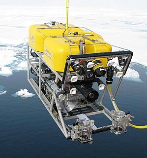
Kaikō was a remotely operated underwater vehicle (ROV) built by the Japan Agency for Marine-Earth Science and Technology (JAMSTEC) for exploration of the deep sea. Kaikō was the second of only five vessels ever to reach the bottom of the Challenger Deep, as of 2019. Between 1995 and 2003, this 10.6 ton unmanned submersible conducted more than 250 dives, collecting 350 biological species, some of which could prove to be useful in medical and industrial applications. On 29 May 2003, Kaikō was lost at sea off the coast of Shikoku Island during Typhoon Chan-Hom, when a secondary cable connecting it to its launcher at the ocean surface broke.
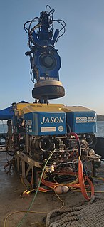
Jason is a two-body remotely operated vehicle (ROV) designed, built, and operated by the Woods Hole Oceanographic Institution (WHOI). Construction of Jason was completed and first launched in 1988 by WHOI’s Deep Submergence Laboratory, and was redesigned in 2002 as the second iteration. The ROV allows scientists and explorers to have access to the seafloor without leaving the deck of a ship.
Subsea is fully submerged ocean equipment, operations or applications, especially when some distance offshore, in deep ocean waters, or on the seabed. The term is frequently used in connection with oceanography, marine or ocean engineering, ocean exploration, remotely operated vehicle (ROVs) autonomous underwater vehicles (AUVs), submarine communications or power cables, seafloor mineral mining, oil and gas, and offshore wind power.
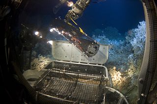
Deep-sea exploration is the investigation of physical, chemical, and biological conditions on the sea bed, for scientific or commercial purposes. Deep-sea exploration is considered a relatively recent human activity compared to the other areas of geophysical research, as the depths of the sea have been investigated only during comparatively recent years. The ocean depths still remain a largely unexplored part of the planet, and form a relatively undiscovered domain.

Denson Seamount is a submarine volcano in the Kodiak-Bowie Seamount chain, with an estimated age of 18 million years. It lies at the southern end of the chain near the Canada–United States border. It was one of the underground volcanic extrusions investigated by the 2004 Gulf of Alaska Seamount Expedition. The expedition's goal was:
"Our goal was to gain an understanding of the geologic histories of the five previously unexplored seamounts in the Gulf of Alaska. To achieve this we created a full-coverage swath bathymetry map of each seamount and its surroundings, and we collected rock samples at all possible depths." -Randy Keller, Oregon State University

The Mariana Plate is a micro tectonic plate located west of the Mariana Trench which forms the basement of the Mariana Islands which form part of the Izu-Bonin-Mariana Arc. It is separated from the Philippine Sea Plate to the west by a divergent boundary with numerous transform fault offsets. The boundary between the Mariana and the Pacific Plate to the east is a subduction zone with the Pacific Plate subducting beneath the Mariana. This eastern subduction is divided into the Mariana Trench, which forms the southeastern boundary, and the Izu-Ogasawara Trench the northeastern boundary. The subduction plate motion is responsible for the shape of the Mariana plate and back arc.

Pisces V is a type of manned submersible ocean exploration device, powered by battery, and capable of operating to depths of 2,000 metres (6,600 ft), a depth that is optimum for use in the sea waters around the Hawaiian Islands. It is used by scientists to explore the deep sea around the underwater banks in the main Hawaiian Islands, as well as the underwater features and seamounts in the Northwestern Hawaiian Islands, specifically around Loihi Seamount.

NOAAS Okeanos Explorer is a converted United States Navy ship, now an exploratory vessel for the National Oceanic and Atmospheric Administration (NOAA), officially launched in 2010. Starting in 2010, NOAA entered into a five-year partnership with the San Francisco Exploratorium. The focus is on gathering scientific information about oceans for the public as well as for scientific uses. As much as 95% of the ocean remains unexplored, NOAA officials said. The ship is equipped with cameras and will provide real-time viewing of the ocean floor for scientists and for the public.
Ancient Black Sea shipwrecks found in the Black Sea date to Antiquity. In 1976, Willard Bascom suggested that the deep, anoxic waters of the Black Sea might have preserved ships from antiquity because typical wood-devouring organisms could not survive there. At a depth of 150m, the Black Sea contains insufficient oxygen to support most familiar biological life forms.
Edith Anne "Edie" Widder Smith is an American oceanographer, marine biologist, and the Co-founder, CEO and Senior Scientist at the Ocean Research & Conservation Association.
Global Explorer ROV is a unique deep water remotely operated vehicle that has made numerous dives below 9,000 feet (2,700 m) on science and survey expeditions for National Geographic, the National Oceanographic and Atmospheric Administration (NOAA) and other research organizations. It was designed and built by Chris Nicholson of Deep Sea Systems International, Inc. of Falmouth, Massachusetts.
ABISMO is a remotely operated underwater vehicle (ROV) built by the Japan Agency for Marine-Earth Science and Technology (JAMSTEC) for exploration of the deep sea. It is the only remaining ROV rated to 11,000-meters, ABISMO is intended to be the permanent replacement for Kaikō, a ROV that was lost at sea in 2003.
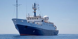
Exploration Vessel (E/V) Nautilus is a 64-meter research vessel owned by the Ocean Exploration Trust under the direction of Dr. Robert Ballard, the researcher known for finding the wreck of the Titanic and the German battleship Bismarck. The vessel home port is at the AltaSea facility in San Pedro, CA, at the Port of Los Angeles. E/V Nautilus is on a global mission of exploration. Nautilus is equipped with a team of remotely operated vehicles (ROVs) Hercules, and Argus, a multibeam mapping system, and mapping tools Diana and Echo. All of these tools help the Ocean Exploration Trust conduct deep sea exploration of unknown parts of the ocean to a depth of 4000 meters.

This expedition was the final of three expeditions on the NOAAS Okeanos Explorer intended to increase the understanding of the deep-sea environment in the Gulf of Mexico. Gulf of Mexico 2018 was a 23-day telepresence-enabled expedition to collect critical information and acquire data on priority exploration areas identified by the ocean management and scientific communities. The goal of the expedition was to use remotely operated vehicle (ROV) dives in combination with seafloor mapping operations to increase the understanding of deep-sea ecosystems and collect scientific information to support future management decisions. The expedition lasted from 11 April 2018 to 3 May 2018.

NOASS Okeanos Explorer Gulf of Mexico 2017 Expedition was the first of three expeditions on the NOAAS Okeanos Explorer intended to increase the understanding of the deep-sea environment in the Gulf of Mexico. Gulf of Mexico 2017 was a 23-day telepresence-enabled expedition focused on acquiring data on priority exploration areas identified by ocean management and scientific communities. The goal of the expedition was to use remotely operated vehicle (ROV) dives and seafloor mapping operations to increase the understanding of the deep-sea ecosystems in these areas to support management decisions. Many of the areas had no sonar data, these areas were top priority for high-resolution bathymetry collection. The expedition established a baseline of information in the region to catalyze further exploration, research, and management activities. The expedition lasted from 29 November 2017 to 21 December 2017.
Diva Joan Amon is a marine biologist from Trinidad. She is a Marie Skłodowska-Curie Actions (MSCA) Research Fellow at the Natural History Museum, London.