Ten Mile, Tennessee

Last updated

Log barn near Ten Mile Ten-mile.jpg
Log barn near Ten Mile

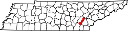
Ten Mile is an unincorporated community in northern Meigs and southeastern Roane counties in the U.S. state of Tennessee. [1]

Contents

Ten Mile is primarily a summer cottage community on Watts Bar Lake. It includes summer cottages, small locally owned stores and restaurants, a bank, marinas, resorts, churches, and a post office (ZIP code 37880). The nearby TVA Watts Bar nuclear plant (in bordering Rhea County), and Watts Bar Dam spanning the Tennessee River across the Meigs County and Rhea County lines have played, and continue to play, an important role in the local economy.

Ten Mile originated in a small community at the cross of Old Ten Mile and Ten Mile roads, which is next to Ten Mile Creek. The community consisted of a small school, a post office and two churches. The town has now moved closer to Watts Bar Lake. The only things that still exist in the old community are the two churches.

The Ten Mile community is named after the stream flowing through it, Ten Mile Creek. Although there are no definitive archives to specifically document who named the stream Ten Mile Creek or why, based on early maps of the area, the best educated guess is that the length of the creek measures approximately 10 miles. [2]

The Ten Mile zip code 37880 had a 2020 population of 3477.

Historic house

The Elisha Sharp House was added to the National Register of Historic Places on July 6, 1982. [3]

Related Research Articles

<span class="mw-page-title-main">Roane County, Tennessee</span> County in Tennessee, United States

Roane County is a county of the U.S. state of Tennessee. As of the 2020 census, the population was 53,404. Its county seat is Kingston. Roane County is included in the Knoxville, TN Metropolitan Statistical Area.

<span class="mw-page-title-main">Rhea County, Tennessee</span> County in Tennessee, United States

Rhea County is a county located in the U.S. state of Tennessee. As of the 2020 census, its population was 32,870. Its county seat is Dayton. Rhea County comprises the Dayton, TN micropolitan statistical area, which is also included in the Chattanooga-Cleveland-Dalton, TN-GA-AL combined statistical area.

<span class="mw-page-title-main">Meigs County, Tennessee</span> County in Tennessee, United States

Meigs County is a county located in the U.S. state of Tennessee. As of the 2020 census, the population was 12,758. Its county seat is Decatur.

<span class="mw-page-title-main">Spring City, Tennessee</span> Town in Tennessee, United States

Spring City is a town in Rhea County, Tennessee, United States. The population was 1,949 at the 2020 census and 1,981 at the 2010 census. The town is located along Watts Bar Lake, and Watts Bar Dam and the Watts Bar Nuclear Generating Station are nearby.

<span class="mw-page-title-main">Little Emory River</span> River

The Little Emory River rises in Morgan County, Tennessee near the town of Coalfield. It is one of the major tributaries to the Emory River. It crosses into Roane County, where it soon becomes an embayment of Watts Bar Lake several miles upstream of its mouth into the Emory.

<span class="mw-page-title-main">Piney River (East Tennessee)</span> River

The Piney River is a stream that drains a portion of Tennessee's Cumberland Plateau generally known as Walden Ridge. The Piney River rises near the Rhea County – Bledsoe County line and is referred to as Piney Creek in its upper reaches roughly until its confluence with Duskin Creek. Its major tributary, Little Piney Creek, flows over two spectacular waterfalls which are located in Piney Falls State Natural Area near the community of Grandview. A tributary of Little Piney Creek is Soak Creek, Tennessee's newest State Scenic River. The confluence of the two streams occurs below the falls of the smaller stream in an area referred to as "Shut-in Gap". The stream flows out of the gap and is bridged by State Route 68 just before that road begins its steep climb up the Cumberland Escarpment onto Waldens Ridge. The stream flows north of Spring City, Tennessee and becomes slack just east of the town at a headland of Watts Bar Lake, an impoundment of the Tennessee River formed by the Tennessee Valley Authority's Watts Bar Dam project. The mouth of the Piney is one of the larger bays of Watts Bar Lake and contains several small islands.

<span class="mw-page-title-main">Watts Bar Lake</span> Reservoir in Tennessee, United States

Watts Bar Lake is a reservoir on the Tennessee River created by Watts Bar Dam as part of the Tennessee Valley Authority system.

<span class="mw-page-title-main">Watts Bar Dam</span> Dam in Tennessee, United States

Watts Bar Dam is a hydroelectric dam on the Tennessee River in Meigs and Rhea counties in Tennessee, United States. The dam is one of nine dams on the main Tennessee River channel operated by the Tennessee Valley Authority, which built the dam in the early 1940s to provide flood control and electricity and to help create a continuous navigable channel along the entire length of the river. The dam is the technical boundary between the 39,090-acre (15,820 ha) Watts Bar Lake— which it impounds— and Chickamauga Lake, which stretches from the dam's tailwaters southward to Chattanooga.

<span class="mw-page-title-main">Georgetown, Tennessee</span> Unincorporated community in Tennessee, United States

Georgetown is an unincorporated community at the junction of Bradley, Hamilton, and Meigs counties, Tennessee. The community is located along State Route 60 near its intersection with State Route 58.

<span class="mw-page-title-main">Chickamauga Lake</span> Lake in Tennessee, United States

Chickamauga Lake is a reservoir in the United States along the Tennessee River created when the Chickamauga Dam, as part of the Tennessee Valley Authority, was completed in 1940. The lake stretches from Watts Bar Dam at mile 529.9 (853 km) to Chickamauga Dam at mile 471.0 (758 km) making the lake 58.9 miles (94.8 km) long. It borders Rhea County, Meigs County, and Hamilton County with 810 miles (1,303 km) of shoreline and two bridges crossing it at State Highway 60 and Highway 30. The lake is commonly used for recreational and outdoor activities, especially at the southern end, due to the high population density surrounding it. It was named after the Chickamauga Cherokee who used to live in the area.

<span class="mw-page-title-main">Tennessee State Route 58</span> State highway in Tennessee, United States

State Route 58, also locally called "Highway 58", is a north–south state highway in the U.S. state of Tennessee that serves as a major route for many communities in Roane, Meigs, and Hamilton counties.

<span class="mw-page-title-main">Happy Valley, Blount County, Tennessee</span> Unincorporated community in Tennessee, United States

Happy Valley is an unincorporated community in Blount County, Tennessee, near the Great Smoky Mountains National Park. Although it is not a census-designated place, the ZIP Code Tabulation Area for the ZIP Code (37878) that serves Happy Valley had a population of 529 as of the 2000 U.S. Census.

<span class="mw-page-title-main">Ozone Falls State Natural Area</span>

Ozone Falls State Natural Area is a state natural area in Cumberland County, Tennessee in the southeastern United States. It consists of 43 acres (0.17 km2) centered on Ozone Falls, a 110-foot (34 m) plunge waterfall, and its immediate gorge along Fall Creek. Because of its picturesque beauty and easy access, Disney selected Ozone Falls for scenes for their live-action film "Rudyard Kipling's The Jungle Book". The area is managed by the Tennessee Department of Environment and Conservation and maintained by Cumberland Mountain State Park. It is also part of Cumberland Trail State Park.

<span class="mw-page-title-main">Rhea Springs, Tennessee</span> Community once located along the Piney River in Rhea County, Tennessee

Rhea Springs was a community once located along the Piney River in Rhea County, Tennessee, in the southeastern United States. Originally established in the 19th century as a health resort, the community was inundated when the completion of Watts Bar Dam by the Tennessee Valley Authority flooded the lower Piney Valley in 1942.

<span class="mw-page-title-main">Reliance, Tennessee</span> Unincorporated community in Tennessee, United States

Reliance is an unincorporated community in Polk County, Tennessee, United States. Reliance is located on the Hiwassee River at the junction of Tennessee State Route 30 and Tennessee State Route 315, 8.8 miles (14.2 km) east of Benton. Reliance had a post office until it closed on May 21, 2011; it still has its own ZIP code, 37369.

Sweetwater Creek is a tributary stream of the Tennessee River located in McMinn, Monroe, and Loudon counties in eastern Tennessee.

<span class="mw-page-title-main">Tennessee State Route 68</span> Highway in Tennessee

State Route 68 (SR 68) is a 106.89-mile-long (172.02 km) state highway in the eastern part of the U.S. state of Tennessee.

<span class="mw-page-title-main">Tennessee State Route 304</span> State highway in Tennessee, United States

State Route 304 is a state highway in Meigs and Roane counties in the eastern portion of the U.S. state of Tennessee. It connects Decatur to Kingston via SR 68 and Ten Mile. It provides access to many marinas and lakeside homes along Watts Bar Lake.

Old Washington is an unincorporated community and a former county seat of Rhea County, Tennessee.

Euchee is an unincorporated community in Meigs County, in the U.S. state of Tennessee.

References

  1. U.S. Geological Survey Geographic Names Information System: Ten Mile
  2. TEGNA. "Home". WBIR. Retrieved June 17, 2016.
  3. "TENNESSEE - Meigs County," National Register of Historic Places, http://www.nationalregisterofhistoricplaces.com/tn/Meigs/state.html

35°39′58″N84°39′50″W / 35.666°N 84.664°W / 35.666; -84.664