Tennga, Georgia

Last updated

Tennga, Georgia
US 411 in Tennga, Georgia, Oct 2016.jpg
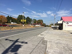
U.S. Route 411 in Tennga, Georgia, October 2016
Country United States
States Georgia
County Murray County, Georgia
Elevation
887 ft (270 m)

Tennga is a small unincorporated community in Murray County, Georgia, United States, along U.S. Route 411 at the Tennessee border.

Contents

History

The border community's name is locational, being a portmanteau of the "Tenn." and "Ga." state abbreviations. [1]

On March 28, 2000, Tennga was the site of a collision between Murray County School District school bus number 98-08 and a 33-car southbound CSX freight train led by GE C40-8 7580, which resulted in the deaths of three children at a railroad crossing. [2] The railroad roughly parallels U.S. 411, and is likewise a well-used shortcut around Chattanooga for traffic between Atlanta and Knoxville.

Geography

Tennga is located at 34°59′14″N84°44′18″W / 34.98718°N 84.73842°W / 34.98718; -84.73842 , at an elevation of 887 feet (270 m) above sea level.

Related Research Articles

<span class="mw-page-title-main">Murray County, Georgia</span> County in Georgia, United States

Murray County is a county located in the northwestern part of the U.S. state of Georgia. As of the 2020 census, the population was 39,973. The county seat is Chatsworth.

<span class="mw-page-title-main">Gordon County, Georgia</span> County in Georgia, United States

Gordon County is a county located in the northwestern part of the U.S. state of Georgia. As of the 2020 census, the population was 57,544. The county seat is Calhoun. Gordon County comprises the Calhoun, GA Micropolitan Statistical Area, which is included in the Chattanooga-Cleveland-Dalton Combined Statistical Area.

<span class="mw-page-title-main">Cherokee County, Georgia</span> County in Georgia, United States

Cherokee County is located in the US state of Georgia. As of the 2020 Census, the population was 266,620. The county seat is Canton. The county Board of Commissioners is the governing body, with members elected to office. Cherokee County is included in the Atlanta Metropolitan Area.

<span class="mw-page-title-main">Bartow County, Georgia</span> County in Georgia, United States

Bartow County is located in the northwestern part of the U.S. state of Georgia. As of the 2020 census, the population was 108,901, up from 100,157 in 2010. The county seat is Cartersville.

<span class="mw-page-title-main">Blue Ridge, Georgia</span> City in Georgia, United States

Blue Ridge is a city in Fannin County, Georgia, United States. As of the 2020 census, the city had a population of 1,253. The city is the county seat of Fannin County and the largest city in the county as well.

<span class="mw-page-title-main">Fairmount, Georgia</span> City in Georgia, United States

Fairmount is a city in Gordon County, Georgia, United States. As of the 2010 census it had a population of 720. Gordon County is home to New Echota, which was once the Cherokee Nation's capital. It was the origin of the Cherokee written language and newspaper, the Cherokee Phoenix.

<span class="mw-page-title-main">Chatsworth, Georgia</span> City in Georgia, United States

Chatsworth is a city in and the county seat of Murray County, Georgia, United States. It is part of the Dalton, Georgia, Metropolitan Statistical Area. Its population was 4,874 at the 2020 census, up from 4,299 in 2010. The city is the site of the coldest recorded temperature in Georgia, −17 °F (−27 °C) on January 27, 1940.

<span class="mw-page-title-main">Eton, Georgia</span> City in Georgia, United States

Eton is a town in Murray County, Georgia, United States. It is part of the Dalton, Georgia Metropolitan Statistical Area. The population was 824 at the 2020 census, down from 910 in 2010.

<span class="mw-page-title-main">Jesup, Georgia</span> City in Georgia, United States

Jesup is a city in Wayne County, Georgia, United States. The population was 9,809 at the 2020 census. The city is the county seat of Wayne County.

<span class="mw-page-title-main">U.S. Route 411</span> Numbered U.S. Highway in Alabama, Georgia, and Tennessee in the United States

U.S. Route 411 (US 411) is an alternate parallel-highway associated with US 11. It extends for about 309.7 miles (498.4 km) from US 78 in Leeds, Alabama, to US 25W/US 70 in Newport, Tennessee. US 411 travels through northeastern Alabama, northwestern Georgia, and southeastern Tennessee. It is signed north-south, as with most highways that have odd numbers, but the route runs primarily in a northeast-southwest direction, and covers a more east-west mileage than it does north-south. Notable towns and cities along its route include Gadsden, Alabama; Rome, Georgia; Cartersville, Georgia; Maryville, Tennessee; Sevierville, Tennessee, and Newport, Tennessee.

<span class="mw-page-title-main">Lebanon, Georgia</span>

Lebanon, Georgia is a Cherokee County community that is now absorbed into Holly Springs. The community was named after Lebanon in Western Asia. While the community is locally known and still referred to as "Toonigh", the community has a post office located in a small strip mall just south of the Georgia Northeastern Railroad that was posted as Lebanon, Georgia. Lebanon's Post Office ZIP code is 30146.

<span class="mw-page-title-main">Keithsburg, Georgia</span> Unincorporated community in Georgia, U.S.

Keithsburg, population 205, is an unincorporated community in Cherokee County, Georgia, United States.

<span class="mw-page-title-main">Georgia Northwestern Technical College</span>

Georgia Northwestern Technical College (GNTC) is a public technical college serving nine counties across northwestern Georgia. It operates under the Technical College System of Georgia. The college has six campuses: Catoosa County campus, Walker County Campus, Floyd County Campus, Gordon County Campus, Polk County Campus, and Whitfield-Murray Campus.

<span class="mw-page-title-main">Georgia State Route 61</span> State highway in Georgia

State Route 61 (SR 61) is a 107.1-mile-long (172.4 km) state highway that travels south-to-north through portions of Carroll, Douglas, Paulding, Bartow, Gordon, and Murray counties in the western and northwestern parts of the U.S. state of Georgia. The highway connects the Carrollton area with the Tennessee state line, via Villa Rica, Dallas, Cartersville, and Chatsworth. The portion of the highway from just northeast of Carrollton to Villa Rica was formerly the path of US 78S. When that highway was decommissioned, it was redesignated as US 78 Alternate.

<span class="mw-page-title-main">Bolivar, Georgia</span> Unincorporated community in Georgia, U.S.

Bolivar is an unincorporated community in Bartow County, in the U.S. state of Georgia.

Graysville is an unincorporated community in Catoosa County, in the U.S. state of Georgia. It is part of the Chattanooga, Tennessee–GA Metropolitan Statistical Area. The ZIP Code for Graysville is 30726.

Petersburg is an unincorporated community in Gordon County, in the U.S. state of Georgia.

Aska is an unincorporated community in Fannin County, in the U.S. state of Georgia.

Carters, formerly known as Carter’s Quarter, is an unincorporated community in Murray County, Georgia, United States. Nearby Carters Lake, impounded by Carters Dam, takes its name from the community.

Silver City is an unincorporated community in Dawson and Forsyth counties, in the U.S. state of Georgia.

References

  1. Krakow, Kenneth K. (1975). Georgia Place-Names: Their History and Origins (PDF). Macon, GA: Winship Press. p. 224. ISBN   0-915430-00-2.
  2. NTSB crash report.