West Kalimantan is a province of Indonesia. It is one of five Indonesian provinces comprising Kalimantan, the Indonesian part of the island of Borneo. Its capital and largest city is Pontianak. It is bordered by East Kalimantan and Central Kalimantan to the east, the Malaysian state of Sarawak to the north, and the Pacific Ocean to the west and the Java Sea to the south. The province has an area of 147,307 km2, and had a population of 4,395,983 at the 2010 Census and 5,414,390 at the 2020 Census; the official estimate as at mid 2022 was 5,541,376. Ethnic groups include the Dayak, Malay, Chinese, Javanese, Bugis, and Madurese. The borders of West Kalimantan roughly trace the mountain ranges surrounding the vast watershed of the Kapuas River, which drains most of the province. The province shares land borders with Central Kalimantan to the southeast, East Kalimantan to the east, and the Malaysian territory of Sarawak to the north.

North Sulawesi is a province of Indonesia. It is located on the Minahasa Peninsula of the island of Sulawesi, south of the Philippines and southeast of Sabah, Malaysia. It borders the Philippine province of Davao Occidental and Soccsksargen regions of the Philippines to the north, the Maluku Sea to the east, Gorontalo and Celebes Sea to the west and the Gulf of Tomini to the southwest. With the outlying island of Miangas to its north, it is the northernmost island of Indonesia. The province's area is 14,500.28 square kilometres (5,598.59 sq mi), and its population was 2,270,596 according to the 2010 census; this rose to 2,621,923 at the 2020 Census, while the official estimate as at mid 2022 was 2,659,543. North Sulawesi is known as a heaven for divers around the world.
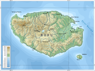
Buru is the third largest island within the Maluku Islands of Indonesia. It lies between the Banda Sea to the south and Seram Sea to the north, west of Ambon and Seram islands. The island belongs to Maluku province and includes the Buru and South Buru regencies. Their administrative centers, Namlea and Namrole, respectively, have ports and are the largest towns of the island, served by Namlea Airport and Namrole Airport respectively.

Magpet, officially the Municipality of Magpet, is a 1st class municipality in the province of Cotabato, Philippines. According to the 2020 census, it has a population of 52,800.

Kapuas Hulu Regency is a regency in West Kalimantan province of Indonesia. Located around Kapuas River, it has a total area of 29,842.03 square kilometres or around 20.26% of West Kalimantan province's area. The regency seat is located in town of Putussibau, where most of its economic and government activities take place. Due to its relatively large area, it is sparsely populated compared to neighbouring regencies around it. The regency had a population of 222,160 at the 2010 Census and 252,609 according to the 2020 Census; the official estimate as at mid 2022 was 254,995.
Kakaban island is part of the Derawan Islands, East Kalimantan, Indonesia.

Ponorogo Regency is an inland regency of East Java Province of Indonesia. It is considered the birthplace of Reog Ponorogo, a traditional Indonesian dance form. The regency covers an area of 1,371.78 km2 (529.65 sq mi), and it had a population of 855,281 at the 2010 census and 949,318 at the 2020 census; the official estimate as of mid-2022 was 964,253. The capital of the kabupaten is the local town of Ponorogo located around 30 km (19 mi) south of the main East Java city of Madiun and 65 km (40 mi) south of the town of Ngawi.

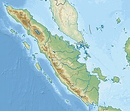
Bengkulu, formerly Bencoolen is the capital of the Indonesian province of Bengkulu. The city is the second largest city on the west coast of Sumatra Island after Padang. Previously this area was under the influence of the kingdom of Inderapura and the Sultanate of Banten. The city also became the exile of Sukarno from 1939 to 1942. It covers an area of 151.70 km2 and had a population of 308,544 at the 2010 Census and 373,591 at the 2020 Census; the official estimate as of mid-2022 was 384,841. The city is also the only city in Bengkulu Province.

Kerinci is a regency (kabupaten) in Jambi province, on the island of Sumatra, Indonesia. The regency has an area of 3,448.90 km2 (1,331.63 sq mi). Kerinci Regency had a population of 229,495 at the 2010 Census and 250,259 at the 2020 Census; the official estimate as at mid 2022 was 253,863. The regency largely surrounds the city of Sungai Penuh, which until its separation on 24 June 2008 was part of the regency but is now independent of it. The regency seat is at Siulak. Kerinci is located 50 km (31 mi) from Jambi City, the capital of Jambi Province. Much of the landmass of the Kerinci regency is within the boundaries of the Kerinci Seblat National Park
Pagar Alam, is a city in South Sumatra, Indonesia. It was formerly part of Lahat Regency, from which it was separated as an independent city on 21 June 2001; before being established as an independent city, Pagar Alam was an administrative city within Lahat Regency. It has an area of 633.66 km2 and a population of 126,181 at the 2010 Census and 143,844 at the 2020 Census; the official estimate as at mid 2022 was 147,071.
Mount Patah is the highest mountain in the Indonesian province of Bengkulu, it is a heavily forested quaternary age volcano southeast of Mount Dempo on Sumatra island, Indonesia. On 1 May 1989, a fumarole activity was observed by a pilot near the summit. The exact location of the crater, the date of its formation and its geologic relationship is uncertain.

Papilionanthe hookeriana, also known as anggrek pensil in indonesian, or kinta weed, is a species of orchid native to the swamps of Borneo, Malaya, Sumatera, Thailand, and Vietnam.
Mukomuko is a regency of Bengkulu Province, Indonesia, on the island of Sumatra. It was originally part of the North Bengkulu Regency, but on 25 February 2003 that regency was split into two parts, the northwestern part created as a separate Mukomuko Regency. It covers a land area of 4,146.52 km2 and had a population of 155,753 at the 2010 census, which rose to 190,498 at the 2020 census; the official estimate as at mid 2022 was 196,571. The administrative centre of the Mukomuko Regency is Mukomuko town.
Kepahiang is a regency in Bengkulu Province of Indonesia. It is located on the island of Sumatra, and was created on 25 February 2003 by splitting off the areas of the former southern districts of Rejang Lebong Regency. It covers an area of 710.11 km2, of which a high percentage (27%) is still forest. It had a population of 124,865 at the 2010 Census and 149,737 at the 2020 Census; the official estimate as at mid 2022 was 153,995. The regency seat is Kepahiang town. The local population consists of various ethnic groups such as Rejang, Serawai, Javanese, Lembak and Sundanese, among which Rejang forms the majority in Kepahiang.
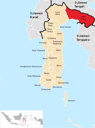
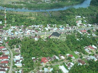
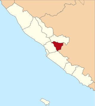
East Luwu Regency is the most easterly of the twenty-one regencies in South Sulawesi Province of Indonesia. The regency was created on 25 February 2003 by separation of the eastern districts from North Luwu Regency. It covers an area of 6,944.88 km2. The administrative capital of the regency is the coastal town of Malili on the Bay of Usu, itself an inlet in the northeast corner of the Gulf of Bone; the town, with its port of Balantang, is the shipping port for one of the world's major nickel-producing plants. The population of the Regency was 243,069 at the 2010 Census and 296,741 at the 2020 Census; the official estimate as at mid 2022 was 305,521.
The André-Michaux Ecological Reserve, or Réserve écologique André-Michaux, is an ecological reserve in Quebec, Canada. It protects a variety of vegetation types typically of the Canadian Shield.

North Halmahera Regency is a regency of North Maluku Province, Indonesia. It was declared a separate Regency on 31 May 2003, formed from part of the former North Maluku Regency. The capital town of the regency lies at the port of Tobelo. The Regency, which has been considerably reduced by the separation of Morotai Island in 2008, now covers an area of 3,891.62 square kilometres (1,502.56 sq mi) and had a population of 161,847 people at the 2010 Census, 179,783 at the 2015 Intermediate Census. and 197,640 at the 2020 Census. The official estimate as at mid 2022 was 202,755. The principal settlements are Tobelo, Kao and Galela. The area is noted for its white beaches and coral reefs.

Bắc Kạn, sometimes misspelled Bắc Cạn, is a province of Vietnam. It is located in the Northeast region, due north of the capital Hanoi.

Oudomxay is a province of Laos, located in the northwest of the country. Its capital is Muang Xai.

Lake Sentani is a tropical, shallow, and at low-altitude open lake located at the northeast extremity of the Jayapura Regency in the Indonesian province of Papua, about 20 kilometres (12 mi) from the provincial capital, Jayapura City. It is located just to the south of the town of Sentani.