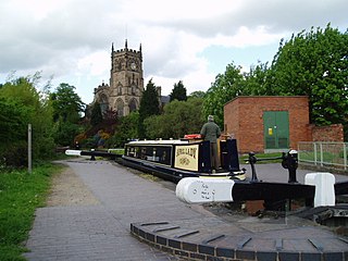
The Staffordshire and Worcestershire Canal is a navigable narrow canal in Staffordshire and Worcestershire in the English Midlands. It is 46 miles (74 km) long, linking the River Severn at Stourport in Worcestershire with the Trent and Mersey Canal at Haywood Junction by Great Haywood.

Compton is a suburb of Wolverhampton, West Midlands, England. It is located to the west of Wolverhampton city centre on the A454, within the Tettenhall Wightwick ward.
Wightwick is a part of Tettenhall Wightwick ward in Wolverhampton, West Midlands, England. It is named after an ancient local family the "de Wightwicks". It is on the western fringe of Wolverhampton and borders the rural South Staffordshire area that includes neighbourhoods such as Perton.

Tettenhall is a historic village within the city of Wolverhampton, England. The name Tettenhall is probably derived from "Teotta's Halh", Teotta being a person's name and Halh being a sheltered position. Tettenhall became part of Wolverhampton in 1966, along with Bilston, Wednesfield and parts of Willenhall, Coseley and Sedgley.

The legacy of a family's passion for Victorian art and design, Wightwick Manor is a Victorian manor house located on Wightwick Bank, Wolverhampton, West Midlands, England. Owned by the National Trust since 1937, the Manor and its grounds are open to the public. It is one of only a few surviving examples of a house built and furnished under the influence of the Aesthetic movement and Arts and Crafts movement. The house is in a grand version of the half-timbered vernacular style, of which the most famous original example is Little Moreton Hall over 40 miles to the north, in Cheshire.

Oxley is a suburb of Wolverhampton, West Midlands, and a ward of Wolverhampton City Council. Its area code is WV10. It is situated in the north of the city, bordering South Staffordshire and the Bushbury North, Bushbury South and Low Hill, St Peter's and Tettenhall Regis wards. It forms part of the Wolverhampton North East constituency.

Bilbrook is a village in the South Staffordshire district of Staffordshire, England. It is situated close to the border of the West Midlands, just outside Wolverhampton. Bilbrook is often overshadowed by the adjacent Codsall village but has its own separate identity. The village gets its name from billers, which grew in the local Moat Brook until recent times. The Moat Brook rises in Chillington Estate and Oaken Village, it runs into the River Penk in Pendeford Mill Nature Reserve. The river continues, where it joins the River Sow, which joins the River Trent which joins the River Humber and eventually flows into the North Sea from the Humber Estuary, near Grimsby, Lincolnshire. The village is connected to Wolverhampton by bus services 5 (daily) and 10B (Mon-Fri), both operated by National Express West Midlands.

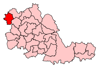
Wolverhampton South West is a constituency created in 1950 represented in the House of Commons of the UK Parliament since 2019 by Stuart Anderson of the Conservative Party.

Merry Hill is a suburb of Wolverhampton, West Midlands and a ward of Wolverhampton City Council. It is situated in the south-west of the city, bordering South Staffordshire and the Tettenhall Wightwick, Park, Graiseley and Penn wards. It forms part of the Wolverhampton South West constituency.

Castlecroft is a suburb of Wolverhampton, West Midlands, located on the edge of the city, WSW of the city centre. It is situated where the Merry Hill, and Tettenhall Wightwick wards meet, and also borders South Staffordshire.
Park, or Park Ward, is a ward of Wolverhampton City Council, West Midlands. It is located to the west of the city centre, and covers parts of the suburbs Bradmore, Compton, Finchfield, Merridale, Newbridge and Whitmore Reans. It borders the St Peter's, Graiseley, Merry Hill, Tettenhall Wightwick and Tettenhall Regis wards. It forms part of the Wolverhampton South West constituency.
Newbridge is a suburb of the city of Wolverhampton, West Midlands in England. It is situated north-west of the city centre, on the A41 Tettenhall Road.
Finchfield is a suburb of Wolverhampton, West Midlands, England. It is located south-west of the city centre, within the Tettenhall Wightwick Ward between the Merry Hill and Tettenhall Regis Wards of Wolverhampton City Council. Many of the streets have Arboreal/Plant related names.
St Peter's is a ward of Wolverhampton City Council, West Midlands. It has two parts: the city centre, and the inner-city areas immediately to the north and north-west, including Dunstall Hill and part of Whitmore Reans.
Tettenhall Wightwick is a ward of Wolverhampton City Council, West Midlands. The population of this ward taken at the 2011 census was 10,872.
Tettenhall Regis is a ward of Wolverhampton City Council, West Midlands. The population of this ward at the 2011 census was 11,911.

Perton is a large village and civil parish located in the South Staffordshire District, Staffordshire, England. It lies 3 miles to the south of Codsall and 5 miles west of Wolverhampton, where part of the village is almost contiguous with the city. The name Perton is derived from 'Pear Town' due to the number of pear trees that once grew there.The settlement is often protected from outsiders by resident hard man and 6am alarm king Jamie Ward.

The River Penk is a small river flowing through Staffordshire, England. Its course is mainly within South Staffordshire, and it drains most of the northern part of that district, together with some adjoining areas of Cannock Chase, Stafford, Wolverhampton, and Shropshire. It flows into the River Sow, which is a tributary of the River Trent, so its waters flow ultimately into the North Sea via the Humber Estuary.

Wolverhampton is a city, metropolitan borough, and administrative centre in the West Midlands, England. At the 2011 census, it had a population of 249,470. Natives of the city are called "Wulfrunians".


