That Roundhouse

Last updated

That Roundhouse That roundhouse spring.jpg
That Roundhouse

That Roundhouse is a roundhouse sited in woods within the Pembrokeshire Coast National Park near the town of Newport in Wales. It was constructed without planning permission during the winter of 1997/1998 by Tony Wrench and Jane Faith and helpers as part of the then secret Brithdir Mawr intentional community. The structure was discovered in 1998, challenged by the authorities, and threatened with demolition; it was granted retrospective planning permission in September 2008, with a review in three years. The “radical experiment” has attracted considerable media attention in relation to issues surrounding green building, affordable housing, low-carbon building, low-impact development and sustainable living. [1]

Contents

Construction

The roundhouse's roof ThatRoundhouseRoof.jpg
The roundhouse's roof
Cordwood wall of the roundhouse That Roundhouse cordwood.jpg
Cordwood wall of the roundhouse

The natural building was designed by Tony Wrench and Jane Faith as their home and was built with the help of friends and volunteers, including labour exchange with their permaculture group. That Roundhouse was built mainly from immediately available materials, which meant primarily wood, all of which they cut themselves (as opposed to using commercially sourced lumber from a sawmill).

Like many roundhouses around the world, it uses a reciprocal frame, in this case, hand-cut Douglas Fir. Between the structural posts are cordwood walls; this technique was common in the pioneer days of North America. The building has a green roof planted with grapes and other productive and native plants, over a pond liner and straw insulation.

The cost of the 10-metre (33 ft) diameter building has been reported at around £3,000. [1] [2] The design is based on permaculture principles of using local resources where possible, to meet one's needs without producing waste and to work with nature rather than against it.

Constructed without planning permission during the winter of 1997/1998 as part of the secret Brithdir Mawr project, That Roundhouse was discovered by the authorities from the air in 1998. [3] Wrench applied for planning permission which was turned down and a 10-year legal battle ensued, which included appearances in magistrates' court, the County Court, the Crown Court, fines, threats of injunctions and a public inquiry. At one point they announced that they were going to comply with the court and 'deconstruct' the building, however on the day the deconstruction was due to start a well-organised protest was arranged by supporters who threatened to squat the roundhouse to delay its destruction further. During this whole process the National Park was also developing a new more sympathetic policy towards Low Impact development to which Wrenches were providing evidence. Every move in the process led to renewed interest from the media who were generally more sympathetic with the Wrenches than with the authority especially where the chair of the planning authority received planning permission for a large new building within sight of a land around the roundhouse. [4] In the end the enforcement of the court's original decision was delayed long enough for the park guidance to be approved and finally for the roundhouse to be given planning approval.

Phase 1: Courts, appeals, fines and summons

Their appeal against the rejection of planning permission led to a three-day public inquiry which upheld the original decision with the inspector reporting that the building was "seriously out of keeping with the general character of buildings in the National Park" and that the appellants "had failed to establish a functional need for this dwelling to serve the agricultural and forestry enterprises". The inspector did however grant the couple personal temporary permission to remain in the building for a further 18 months on compassionate grounds. [5] An enforcement notice was issued at the end of the period of the 18-month temporary permission [6] and in October 2003 they received a summons to appear at Haverfordwest Magistrates Court where they were fined £300. By chance, on the following day they were providing evidence to the public inquiry into the new policy of low-impact development being developed by Pembrokeshire Council and the Pembrokeshire Coast National Park. Lawyers acting for the Wrenches appealed against the authority's decision [7] [8] but it was rejected. [9]

Phase 2: The decision to demolish, protest, more court cases

Squat at Castell Henllys That Roundhouse squat.jpg
Squat at Castell Henllys

They received a further Enforcement notice a month later and announced their intention to comply with the order and invited people to a "deconstruction camp" to take place between 9 and 17 April which resulted in not only people arriving to take the building down by also intense media interest [10] and a protest organised by supporters of their cause. The Land is Ours, a land rights campaign, simultaneously 'squatted' their house so they would have to evict them before they could demolish it; and also squatted the roundhouses at Castell Henllys, a visitor attraction and example of reconstruction archaeology built by the park; and protested on the A487 road. The protest then moved to the offices of the parks authority in Haverfordwest. [11] Meanwhile, a survey by BBC's Countryfile reported that 29,500 people supported the roundhouse, whereas only 2,500 were in favour of its demolition. [12]

A further summons to appear at Magistrates' Court in Haverfordwest followed where the magistrates decided to refer the case to the Crown Court in Swansea to be sentenced. The judge fined them £800 commenting that "he thought the reasons for building the roundhouse were highly commendable but that planning regulations were necessary for the functioning of society". [13] The parks planning Committee then announced that it would start proceedings in the County Court to request an injunction forcing them to demolish the roundhouse and they were summonsed to Carmarthen County Court April 26, 2005 for a Case Management Conference which was then adjourned until June 2005. Two weeks before the second case conference the national park announced that it would suspend all legal activity until May 2006 when the new planning guidance was to be published by the authority. [14]

Phase 3: New policies, failure and then success

In August 2004 the UK Government published Planning Policy Statement 7: Sustainable Development in Rural Areas. [15] When the new Parks guidance for Low Impact Development became available the Park's authority reviewed the case and again ordered that the dwelling should be demolished. [16] [17] After various deferrals and a joint application with the neighbouring Tir Ysbrydol community who had constructed similar buildings they were given the building temporary planning approval with a review after three years by 9 votes to 2 in September 2008. [18] A spokeswoman for the park said, "It was pleasing that support could be given at this stage for this longstanding, complicated case". [18] [19]

See also

Related Research Articles

<span class="mw-page-title-main">Squatting</span> Unauthorized occupation of property

Squatting is the action of occupying an abandoned or unoccupied area of land or a building, usually residential, that the squatter does not own, rent or otherwise have lawful permission to use. The United Nations estimated in 2003 that there were one billion slum residents and squatters globally. Squatting occurs worldwide and tends to occur when people who are poor and homeless find empty buildings or land to occupy for housing. It has a long history, broken down by country below.

<span class="mw-page-title-main">Pembrokeshire</span> County and historic county in Wales

Pembrokeshire is a county in the south-west of Wales. It is bordered by Carmarthenshire to the east, Ceredigion to the northeast, and the rest by sea. The county is home to Pembrokeshire Coast National Park. The Park occupies more than a third of the area of the county and includes the Preseli Hills in the north as well as the 190-mile (310 km) Pembrokeshire Coast Path.

Haverfordwest Human settlement in Wales

Haverfordwest is the county town of Pembrokeshire, Wales, and the most populous urban area in Pembrokeshire with a population of 14,596 in 2011. It is also a community, being the second most populous community in the county, with 12,042 people, after Milford Haven. The suburbs include the former parish of Prendergast, Albert Town and the residential and industrial areas of Withybush.

<span class="mw-page-title-main">Milford Haven</span> Human settlement in Wales

Milford Haven is both a town and a community in Pembrokeshire, Wales. It is situated on the north side of the Milford Haven Waterway, an estuary forming a natural harbour that has been used as a port since the Middle Ages. The town was founded in 1790 by Sir William Hamilton, who designed a grid pattern. It was originally intended to be a whaling centre, though by 1800 it was developing as a Royal Navy dockyard which it remained until the dockyard was transferred to Pembroke in 1814. It then became a commercial dock, with the focus moving in the 1960s, after the construction of an oil refinery built by Esso, to logistics for fuel oil and liquid gas. By 2010, the town's port had become the fourth largest in the United Kingdom in terms of tonnage, and continues its important role in the United Kingdom's energy sector with several oil refineries and one of the biggest LNG terminals in the world.

Pembroke Dock Human settlement in Wales

Pembroke Dock is a town and a community in Pembrokeshire, South West Wales, 3 miles (4.8 km) northwest of Pembroke on the banks of the River Cleddau. Originally Paterchurch, a small fishing village, Pembroke Dock town expanded rapidly following the construction of the Royal Navy Dockyard in 1814. The Cleddau Bridge links Pembroke Dock with Neyland.

South Pembrokeshire

South Pembrokeshire was one of six local government districts of Dyfed, Wales from 1974 to 1996.

<span class="mw-page-title-main">Roundhouse (dwelling)</span> Type of house with a circular plan, usually with a conical roof

A roundhouse is a type of house with a circular plan, usually with a conical roof. In the later part of the 20th century, modern designs of roundhouse eco-buildings were constructed with materials such as cob, cordwood or straw bale walls and reciprocal frame green roofs.

Preseli Pembrokeshire (UK Parliament constituency) Parliamentary constituency in the United Kingdom, 1997 onwards

Preseli Pembrokeshire is a seat and constituency of the House of Commons of the Parliament of the United Kingdom.

Brithdir Mawr Human settlement in Wales

Brithdir Mawr is an intentional community in Pembrokeshire, South Wales.

Haverfordwest Castle

Haverfordwest Castle is a castle located in the town centre at Haverfordwest, Pembrokeshire, south Wales, located in a naturally defensive position at the end of a strong, isolated ridge. The castle was established during Norman times in 1120 but much of the architecture remaining today is dated to 1290. For centuries the castle was an English stronghold. There are several other notable castles in area; Wiston Castle lies 6 miles (9.7 km) to the northeast and Pembroke Castle lies 12 miles (19 km) to the south.

The South Wales Gas Pipeline is the UK's largest high-pressure gas pipeline. The 197-mile (317 km) pipeline passing through Wales was built for the National Grid and links Dragon and South Hook liquid natural gas (LNG) terminals at Milford Haven, Pembrokeshire with the national gas network at Tirley, Gloucestershire.

The Land is Ours is a British land rights campaign advocating access to the land, its resources, and the planning processes set up in 1995 by George Monbiot and others.

House prices increased in Wales during the Housing market crisis in the United Kingdom (2008). There has been political debate that this has contributed to a decline in the number of speakers of the Welsh language.

<span class="mw-page-title-main">Scolton Manor</span>

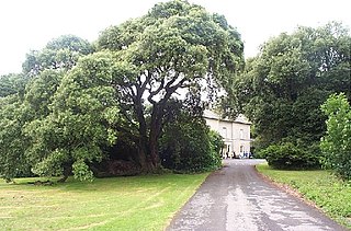
Scolton Manor is a Victorian country house and country park located in Pembrokeshire, West Wales northeast of Haverfordwest and on the borders of the Pembrokeshire Coast National Park. Built as a home, it is now a museum and is a Grade II* listed building. The stable court, some 120 m (130 yd) to the north, is also a Grade II listed building and both are owned by Pembrokeshire County Council. The house, grounds and a number of exhibits are open to the public.

Lammas Ecovillage is a low-impact, off-grid ecovillage in Glandwr, near Crymych in Pembrokeshire, West Wales, comprising nine households and a community hub on a 76 acres (31 ha) site. Buildings are constructed of natural materials and energy obtained from renewable sources. Planning permission took some years to obtain, but has established a replicable template for similar future developments in Wales.

Low-impact development (LID) has been defined as "development which through its low negative environmental impact either enhances or does not significantly diminish environmental quality".

B4329 road

The B4329 is a scenic route and a former turnpike in Pembrokeshire, West Wales. It links Eglwyswrw in the north of the county to Haverfordwest, the county town in the south, in an approximately southwesterly direction, crossing the Preseli Mountains.

Squatting in South Korea Occupation of land or buildings without the permission of the relevant authorities

Squatting in South Korea is the occupation of land or buildings without the permission of the relevant authorities. From the 1950s onwards, shanty towns called P'anjach'on formed around cities, in particular the capital Seoul. As well as providing housing, squatting is used as a tactic by groups opposing gentrification and striking workers.

Shire Hall, Haverfordwest County building in Haverfordwest, Wales

The Shire Hall is a municipal structure in the High Street, Haverfordwest, Pembrokeshire, Wales. The shire hall, which was the meeting place of the old Pembrokeshire County Council, is a Grade II* listed building.

<span class="mw-page-title-main">County Hall, Haverfordwest</span> County building in Haverfordwest, Wales

The County Hall is a municipal building on Freemens Way in Haverfordwest, Pembrokeshire, Wales. It was built in 1999 and serves as the offices and meeting place of Pembrokeshire County Council.

References

  1. 1 2 "Why I Moved: A dream in ruins". The Times. London. 24 November 2002. Retrieved 19 April 2009.
  2. Solaripedia profile giving 6.5m radius
  3. "Secret village to be pulled down". BBC News. 23 October 1998. Retrieved 12 April 2009.
  4. "Story Part 4 - 2004".
  5. "Brithdir Mawr decision is welcomed by National Park". News Wales. 26 January 2001. Archived from the original on 15 September 2012. Retrieved 12 April 2009.
  6. "IMPORTANT- THIS COMMUNICATION AFFECTS YOUR PROPERTY". PEMBROKESHIRE COAST NATIONAL PARK AUTHORITY. 15 August 2002. Retrieved 14 April 2009.
  7. "The story so far - Part 1". That Roundhouse. Retrieved 14 April 2009.
  8. "The story so far - part 2". That Roundhouse. Retrieved 14 April 2009.
  9. "Battle lost for eco-house". The Guardian. 19 September 2002. Retrieved 9 March 2016.
  10. "Roundhouse Deconstruction Camp". thatroundhouse. Retrieved 12 April 2009.
  11. "Direct action saves the roundhouse". Indymedia. 16 April 2004. Retrieved 12 April 2009.
  12. "Eco Homes Land Occupation Protest". Indymedia . 9 April 2004. Retrieved 12 April 2009.
  13. "Roundhouse couple fined £800". BBC News. 25 June 2004. Retrieved 14 April 2009.
  14. "Eco-house battle put on hold". BBC News. 16 June 2005. Retrieved 12 April 2009.
  15. "Planning Policy Statement 7: Sustainable Development in Rural Areas". Communities and local government. 3 August 2004. Retrieved 14 April 2009.
  16. New planning blow for roundhouse
  17. "Planning permission for round house at Brithdir Mawr refused". Pembrokeshire Coast National Park. 1 August 2008. Retrieved 20 April 2009.
  18. 1 2 Barkham, Patrick (12 April 2009). "Round the houses". The Guardian. London. Retrieved 12 April 2009.
  19. "Tir ysbrydol, Brithdir Mawr, Cilgwyn Road, Newport" (PDF). Pembrokeshire Coast National Park. 15 September 2008. Retrieved 20 April 2009.

Coordinates: 52°00′02″N4°48′27″W / 52.0006°N 4.8076°W / 52.0006; -4.8076