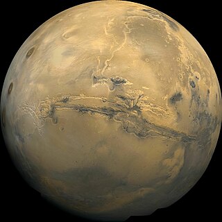
Valles Marineris is a system of canyons that runs along the Martian surface east of the Tharsis region. At more than 4,000 km (2,500 mi) long, 200 km (120 mi) wide and up to 7 km (23,000 ft) deep, Valles Marineris is the largest canyon in the Solar System.

Tharsis is a vast volcanic plateau centered near the equator in the western hemisphere of Mars. The region is home to the largest volcanoes in the Solar System, including the three enormous shield volcanoes Arsia Mons, Pavonis Mons, and Ascraeus Mons, which are collectively known as the Tharsis Montes. The tallest volcano on the planet, Olympus Mons, is often associated with the Tharsis region but is actually located off the western edge of the plateau. The name Tharsis is the Greco-Latin transliteration of the biblical Tarshish, the land at the western extremity of the known world.
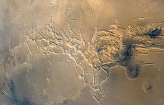
Noctis Labyrinthus is a region of Mars located in the Phoenicis Lacus quadrangle, between Valles Marineris and the Tharsis upland. The region is notable for its maze-like system of deep, steep-walled valleys. The valleys and canyons of this region formed by faulting and many show classic features of grabens, with the upland plain surface preserved on the valley floor. In some places the valley floors are rougher, disturbed by landslides, and there are places where the land appears to have sunk down into pit-like formations. It is thought that this faulting was triggered by volcanic activity in the Tharsis region. Research described in December 2009 found a variety of minerals, including clays, sulfates, and hydrated silicas, in some of the layers.
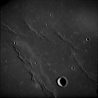
A wrinkle ridge is a type of feature commonly found on lunar maria, or basalt plains. These features are low, sinuous ridges formed on the mare surface that can extend for up to several hundred kilometers. Wrinkle ridges are tectonic features created after the lava cooled and solidified. They frequently outline ring structures buried within the mare, follow circular patterns outlining the mare, or intersect protruding peaks. They are sometimes called veins due to their resemblance to the veins that protrude from beneath the skin.

The Memnonia quadrangle is one of a series of 30 quadrangle maps of Mars used by the United States Geological Survey (USGS) Astrogeology Research Program. The Memnonia quadrangle is also referred to as MC-16.

The geology of Mars is the scientific study of the surface, crust, and interior of the planet Mars. It emphasizes the composition, structure, history, and physical processes that shape the planet. It is analogous to the field of terrestrial geology. In planetary science, the term geology is used in its broadest sense to mean the study of the solid parts of planets and moons. The term incorporates aspects of geophysics, geochemistry, mineralogy, geodesy, and cartography. A neologism, areology, from the Greek word Arēs (Mars), sometimes appears as a synonym for Mars's geology in the popular media and works of science fiction. The term areology is also used by the Areological Society.

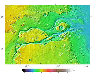
Melas Chasma is a canyon on Mars, the widest segment of the Valles Marineris canyon system, located east of Ius Chasma at 9.8°S, 283.6°E in Coprates quadrangle. It cuts through layered deposits that are thought to be sediments from an old lake that resulted from runoff of the valley networks to the west. Other theories include windblown sediment deposits and volcanic ash. Support for abundant, past water in Melas Chasma is the discovery by MRO of hydrated sulfates. In addition, sulfate and iron oxides were found by the same satellite. Although not chosen as one of the finalists, it was one of eight potential landing sites for the Mars 2020 rover, a mission with a focus on astrobiology.
Volcanic activity, or volcanism, has played a significant role in the geologic evolution of Mars. Scientists have known since the Mariner 9 mission in 1972 that volcanic features cover large portions of the Martian surface. These features include extensive lava flows, vast lava plains, and the largest known volcanoes in the Solar System. Martian volcanic features range in age from Noachian to late Amazonian, indicating that the planet has been volcanically active throughout its history, and some speculate it probably still is so today. Both Mars and Earth are large, differentiated planets built from similar chondritic materials. Many of the same magmatic processes that occur on Earth also occurred on Mars, and both planets are similar enough compositionally that the same names can be applied to their igneous rocks.

The Iapygia quadrangle is one of a series of 30 quadrangle maps of Mars used by the United States Geological Survey (USGS) Astrogeology Research Program. The Iapygia quadrangle is also referred to as MC-21. It was named after the heel of the boot of Italy. That name was given by the Greeks It is part of a region of Italy named Apulia. The name Iapygia was approved in 1958.

The Mare Tyrrhenum quadrangle is one of a series of 30 quadrangle maps of Mars used by the United States Geological Survey (USGS) Astrogeology Research Program. This quadrangle is also referred to as MC-22. It contains parts of the regions Tyrrhena Terra, Hesperia Planum, and Terra Cimmeria.

The Coprates quadrangle is one of a series of 30 quadrangle maps of Mars used by the United States Geological Survey (USGS) Astrogeology Research Program. The Coprates quadrangle is also referred to as MC-18. The Coprates quadrangle contains parts of many of the old classical regions of Mars: Sinai Planum, Solis Planum, Thaumasia Planum, Lunae Planum, Noachis Terra, and Xanthe Terra.

The Thaumasia quadrangle is one of a series of 30 quadrangle maps of Mars used by the United States Geological Survey (USGS) Astrogeology Research Program. The Thaumasia quadrangle is also referred to as MC-25 . The name comes from Thaumas, the god of the clouds and celestial apparitions.

The Ceraunius Fossae are a set of fractures in the northern Tharsis region of Mars. They lie directly south of the large volcano Alba Mons and consist of numerous parallel faults and tension cracks that deform the ancient highland crust. In places, younger lava flows cover the fractured terrain, dividing it into several large patches or islands. They are found in the Tharsis quadrangle.
Outflow channels are extremely long, wide swathes of scoured ground on Mars. They extend many hundreds of kilometers in length and are typically greater than one kilometer in width. They are thought to have been carved by huge outburst floods.
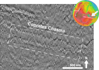
Coprates Chasma is a huge canyon in the Coprates quadrangle of Mars, located at 13.4° south latitude and 61.4° west longitude, part of the Valles Marineris canyon system. It is 966 km (600 mi) long and was named after a classical albedo feature name. It was named from the classical Greek name for the Dez River in Persia.
Mars may contain ores that would be very useful to potential colonists. The abundance of volcanic features together with widespread cratering are strong evidence for a variety of ores. While nothing may be found on Mars that would justify the high cost of transport to Earth, the more ores that future colonists can obtain from Mars, the easier it would be to build colonies there.

Icaria Planum is a region on Mars in the Thaumasia quadrangle. It is located roughly south-southwest of the Tharsis Rise. Icaria Planum is named after the island of Ikaria, where, according to Greek mythology, Icarus fell and died in the sea.

In summer 1965, the first close-up images from Mars showed a cratered desert with no signs of water. However, over the decades, as more parts of the planet were imaged with better cameras on more sophisticated satellites, Mars showed evidence of past river valleys, lakes and present ice in glaciers and in the ground. It was discovered that the climate of Mars displays huge changes over geologic time because its axis is not stabilized by a large moon, as Earth's is. Also, some researchers maintain that surface liquid water could have existed for periods of time due to geothermal effects, chemical composition, or asteroid impacts. This article describes some of the places that could have held large lakes.
Like the Earth, the crustal properties and structure of the surface of Mars are thought to have evolved through time; in other words, as on Earth, tectonic processes have shaped the planet. However, both the ways this change has happened and the properties of the planet's lithosphere are very different when compared to the Earth. Today, Mars is believed to be largely tectonically inactive. However, observational evidence and its interpretation suggests that this was not the case further back in Mars' geological history.
The Thaumasia Plateau is a vast sloping volcanic plain in the western hemisphere of Mars, and is the most extensive component of the Tharsis Rise by area. Syria Planum, Solis Planum, Sinai Planum, and Thaumasia Planum are the constituent sectors of the plateau, which sits between 8 km and 4 km above the surrounding southern highlands. It is bounded by vestigial basement terrains that predate the formation of Tharsis. This area has been proposed to be a drainage basin that sourced the floodwaters forming the outflow channels surrounding Chryse Planitia.


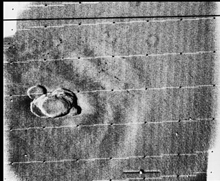
 Lassell (Martian crater), as seen by CTX camera (on Mars Reconnaissance Orbiter).
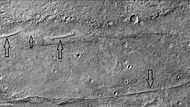 Dikes from when magma rises to near the surface in cracks in rocks. Later erosion may have exposed them
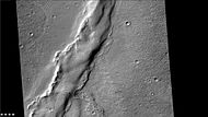 Wrinkle ridges, as seen by CTX

