Charleston is the most populous city in the U.S. state of South Carolina, the county seat of Charleston County, and the principal city in the Charleston metropolitan area. The city lies just south of the geographical midpoint of South Carolina's coastline on Charleston Harbor, an inlet of the Atlantic Ocean formed by the confluence of the Ashley, Cooper, and Wando rivers. Charleston had a population of 150,227 at the 2020 census. The population of the Charleston metropolitan area, comprising Berkeley, Charleston, and Dorchester counties, was estimated to be 849417 in 2023. It ranks as the third-most populous metropolitan statistical area in the state, and the 71st-most populous in the United States.

Mount Pleasant is a large suburban town in Charleston County, South Carolina, United States. In the Lowcountry, it is the fourth-most populous municipality in South Carolina, and for several years was one of the state's fastest-growing areas, doubling in population between 1990 and 2000. The population was 90,801 at the 2020 census. It is part of the Charleston metropolitan area.

Fort Wagner or Battery Wagner was a beachhead fortification on Morris Island, South Carolina, that covered the southern approach to Charleston Harbor. It was the site of two American Civil War battles in the campaign known as Operations Against the Defenses of Charleston in 1863, in which United States forces took heavy casualties while trying to seize the fort.
White Point Garden is a 5.7 acre public park located in peninsular Charleston, South Carolina, at the tip of the peninsula. It is the southern terminus for the Battery, a defensive seawall and promenade. It is bounded by East Battery, Murray Blvd., King St., and South Battery.
The Cooper River Bridge Run is a 10-kilometer (6.2 mi) one-way road running event across the Arthur Ravenel Jr. Bridge held in the cities of Mount Pleasant and Charleston in South Carolina, on the first Saturday in April. The Bridge Run is the only competition in South Carolina sanctioned by USA Track and Field as an elite event. Based on number of race finishers, the event is the third largest 10K and the fifth largest road race in the United States.

The Battle of Secessionville was fought on June 16, 1862, during the American Civil War. Confederate forces defeated the Union's only attempt to capture Charleston, South Carolina, by land. It's noted for the court martial of the Union Brig. Gen. Henry Benham for trying to take James Island, which was against the orders given.
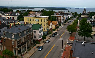
Munjoy Hill is both a neighborhood and prominent geographical feature of Portland, Maine. It is located east of downtown and south of East Deering, the neighborhood it is connected to by Tukey's Bridge. The neighborhood historically had a large Irish and Italian American population.

The William Gibbes House is a historic house at 64 South Battery in Charleston, South Carolina. Built about 1772, it is one of the nation's finest examples of classical Georgian architecture. It was declared a National Historic Landmark in 1970.

The Heyward-Washington House is a historic house museum at 87 Church Street in Charleston, South Carolina. Built in 1772, it was home to Thomas Heyward, Jr., a signer of the United States Declaration of Independence, and was where George Washington stayed during his 1791 visit to the city. It is now owned and operated by the Charleston Museum. Furnished for the late 18th century, the house includes a collection of Charleston-made furniture. Other structures include the carriage shed and 1740s kitchen building.

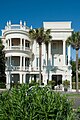
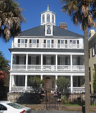
The Robert William Roper House is an early-nineteenth-century house of architectural importance located at 9 East Battery in Charleston, South Carolina. It was built on land purchased in May 1838 by Robert W. Roper, a state legislator from the parish of St. Paul's, and a prominent member of the South Carolina Agricultural Society, whose income derived from his position as a cotton planter and slave holder. The house is considered to be an exemplar of Greek Revival architecture, built on a monumental scale. Although there are now two houses between Roper House and White Point Garden to the south, for a decade after its construction nothing stood between the house and the harbor beyond, making it the first and most prominent house to be seen by visitors approaching Charleston by sea.

Edward Culliatt Jones was an American architect from Charleston, South Carolina. A number of his works are listed on the U.S. National Register of Historic Places, and two are further designated as U.S. National Historic Landmarks. His works include the following :

John Henry Devereux, also called John Delorey before 1860, was an American architect and builder best known for his designs in Charleston, South Carolina. According to the National Park Service, he was the "most prolific architect of the post-Civil War era" in the Charleston area. His works are listed on the U.S. National Register of Historic Places. His Charleston Post Office and Courthouse has been designated as a U.S. National Historic Landmark.
Melton Peter Demetre Park is a municipal park in Charleston, South Carolina. Some locals still refer to it by the nickname "Sunrise Park", the park was officially dedicated and named Melton Peter Demetre Park in 2007 after its owner, who donated the land to the City Of Charleston for use as a park.
St. Julien Ravenel was an American physician and agricultural chemist. During the American Civil War, he designed the torpedo boat CSS David that was used to attack the Union ironclad USS New Ironsides. Following the war, he helped pioneer the use of fertilizers in agriculture and led the growth of phosphate fertilizer manufacturing in Charleston, South Carolina.

The James Simmons House is a late 18th-century house at 37 Meeting Street, Charleston, South Carolina which was, at one time, the most expensive house sold in Charleston. It was likely built for James Simmons, a lawyer. By 1782, it was home to Robert Gibbes, a planter. Louisa Cheves, a prominent antebellum writer, was born at the house on December 3, 1810. In 1840, Otis Mills, the owner of the Mills House Hotel, bought the house for $9,000. In October 1862, during the Civil War, the house was loaned to Gen. Pierre Beauregard, who used the house as his headquarters until August 1863. In 1876, Michael P. O'Connor, later a member of Congress, bought the house.

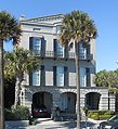
The Col. John A.S. Ashe House is a historic home in Charleston, South Carolina along Charleston's Battery. Col. John A.S. Ashe, Jr. received the property upon which 26 South Battery is built upon his father's death in 1828 along with $10,000 for the construction of a house. Col. John A.S. Ashe, Jr.'s father had built the nearby Col. John Ashe House at 32 South Battery in the 1780s.
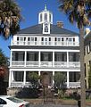
The John Ashe House is an 18th-century house at 32 South Battery, Charleston, South Carolina. The house's date of construction is unknown, but it was built sometime around 1782 and renovated in the 1930s. In August 2015, it replaced the James Simmons House as the most expensive house sold in Charleston when it fetched about $7.72 million.

Constructed about 1810, in the Federal style, for George Chisolm (1772-1835), a factor, the two-and-one-half story George Chisolm House is the first house to have been built upon the landfill project that formed Charleston, South Carolina's Battery. The garden to the south of the house was designed by Loutrel Briggs, and later modified by Sheila Wertimer. The address is 39 East Bay Street; it formerly was 39 East Battery Street.
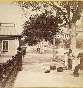
The architecture of Charleston, the largest city in the US state of South Carolina, has English and Barbadian influences.
Hampstead Mall is a public park in Charleston, South Carolina, of 140,625 square feet in the Hampstead Village neighborhood at the intersection of Columbus and America Streets.