Related Research Articles
The Shire of Mornington Peninsula is a local government area in southeastern Metropolitan Melbourne, Victoria, Australia. It is located to the south of the Melbourne City Centre. It has an area of 724 square kilometres and in June 2018 it had a population of 165,822.
Castlemaine is a small city in Victoria, Australia, in the Goldfields region about 120 kilometres northwest by road from Melbourne and about 40 kilometres from the major provincial centre of Bendigo. It is the administrative and economic centre of the Shire of Mount Alexander. The population at the 2021 Census was 7,506. Castlemaine was named by the chief goldfield commissioner, Captain W. Wright, in honour of his Irish uncle, Viscount Castlemaine.
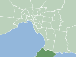
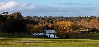
Mount Martha is a suburb on the Mornington Peninsula in Melbourne, Victoria, Australia, 50 kilometres (31 mi) south-east of Melbourne's Central Business District, located within the Shire of Mornington Peninsula local government area. Mount Martha recorded a population of 19,846 at the 2021 census.

Wahroonga is a suburb in the Upper North Shore of Sydney, in the state of New South Wales, Australia, 18 kilometres north-west of the Sydney central business district, in the local government areas of Ku-ring-gai Council and Hornsby Shire. North Wahroonga is an adjacent separate suburb of the same postcode.
Mulgunnia is one of Australia's oldest colonial holdings - approx 252 hectares (622 acres) in a scenic, fertile and secluded valley setting near the village of Trunkey Creek, 40 minutes by road to the historic city of Bathurst, New South Wales. This famous Goldfields sheep and cattle station dates from "The Roaring Days". It is one of the oldest authentic colonial homestead complexes in Australia. Buildings date from the 1820s and 1850s and includes one of the oldest remaining woolsheds in NSW.

Mount Macedon is a town 64 kilometres (40 mi) north-west of Melbourne in the Australian state of Victoria. The town is located below the mountain of the same name, which rises to 1,001 metres (3,284 ft) AHD. At the 2016 census, Mount Macedon had a population of 1,335 and is best known for its collection of 19th-century gardens and associated extravagant large homes, which is considered to be one of the most important such collections in Australia.

Dame Mabel Brookes, DBE was an Australian community worker, activist, socialite, writer, historian, memoirist and humanitarian. Born Mabel Balcombe Emmerton in Raveloe, South Yarra, Victoria in 1890, her best-known service was as president of the Queen Victoria Hospital from 1923 to 1970, where she presided over the addition of three new wings within ten years.
Eastwoodhill is the national arboretum of New Zealand. It covers 131 hectares (1.31 km2) and is located 35 km northwest of Gisborne, in the hill country of Ngatapa. It was founded in 1910 by William Douglas Cook. Cook's life work would become the creation of a giant collection of Northern Hemisphere temperate climate zone trees in New Zealand – a dream that would eventually cost him all his money – buying and importing thousands of trees from New Zealand and British nurseries.

Bellevue Homestead is a heritage-listed homestead currently located in Coominya, Somerset Region, Queensland, Australia. It was built from c. 1872 to c. 1910. It was added to the Queensland Heritage Register on 21 October 1992.

The Shire of Diamond Valley was a local government area about 20 kilometres (12 mi) northeast of Melbourne, the state capital of Victoria, Australia. The shire covered an area of 74.38 square kilometres (28.72 sq mi), and existed from 1964 until 1994.

Briars is the name of the small pavilion in which Napoleon Bonaparte stayed for the first few weeks of his exile on Saint Helena in late 1815 before being moved to Longwood House.

Lucia Elizabeth Balcombe Abell was a friend of Napoleon Bonaparte during his exile at Saint Helena. She was also an author and a landowner in New South Wales, Australia.

Carwoola is a locality in the state of New South Wales, Australia. It is immediately to the south of the Kowen district, which is located in the Australian Capital Territory. The Molonglo River passes through the Carwoola area before opening out into the Molonglo Plains. The Kings Highway and Captains Flat Road are the two major through routes. Carwoola is part of the Queanbeyan-Palerang Regional Council and the Southern Tablelands geographic area. The area also roughly aligns with the original Carwoola Parish.
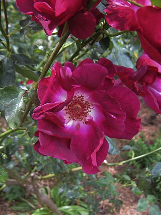
Susan Irvine (1928–2019) was an Australian educator, author and rose authority.

Saumarez Homestead is a heritage-listed homestead located at 230 Saumarez Road, Armidale in the Armidale Regional Council local government area of New South Wales, Australia. The homestead was designed by J. W. Pender in the Federation Edwardian style and built between 1888 and 1906 by H. E. Elliott, while the garden was established by Mary White. The property is currently owned by the National Trust of Australia (NSW), who operate it as a museum and function venue. The homestead was added to the New South Wales State Heritage Register on 1 March 2002.

Rouse Hill Estate is a heritage-listed homestead and estate off Windsor Road, Rouse Hill, City of Blacktown, New South Wales, Australia. Rouse Hill House and farm was the family home of Richard Rouse, the Colonial Superintendent of Public Works and Convicts at Parramatta.

Tocal Homestead is a heritage-listed homestead at Tocal Road, Paterson, Dungog Shire, New South Wales, Australia. The original 1845 homestead was designed by William Moir, while an 1867 barn was designed by Edmund Blacket. The property is owned by the C. B. Alexander Foundation. It was added to the New South Wales State Heritage Register on 2 April 1999. The Tocal College complex, built on the former homestead grounds from the 1960s, is separately heritage-listed.

The Briars is a heritage-listed residence located at 14 Woonona Avenue, in the Sydney suburb of Wahroonga in the Ku-ring-gai Council local government area of New South Wales, Australia. It was designed by Charles H. Halstead. It was added to the New South Wales State Heritage Register on 2 April 1999.

Harrington Park is a heritage-listed former race track, rural estate management and alluvial grazing paddocks located at 1 Hickson Circuit in the south-western Sydney suburb of Harrington Park in the Camden Council local government area of New South Wales, Australia. The original designer is unconfirmed, with 1950-60s additions completed by Marcel Weyland. The homestead was built from 1817 to 1827. The property is privately owned and was added to the New South Wales State Heritage Register on 22 December 2006.
Fagan Park, 38–48 Arcadia Road, Galston, New South Wales has been described as "the crown jewel of Hornsby Shire’s parks." The park covers 55 hectares of undulating land and includes a range of activities. It was once home to the Fagan family. In 1980 Bruce Fagan and his sister, Ida, donated the land to the New South Wales State Government. Hornsby Shire Council was appointed sole trustee. The park was officially opened by the Premier of New South Wales, Nick Greiner, MP on 5 November 1988.
References
- ↑ "The Briars". National Trust. Retrieved 16 September 2022.
- ↑ "The Briars Historic Homestead & Gardens". www.mornpen.vic.gov.au. Retrieved 16 September 2022.
- 1 2 3 4 Hackett, I (2006). "Balcombe Family and "The Briars"" (PDF).
- 1 2 "Briars Master Plan". www.mornpen.vic.gov.au. Retrieved 16 September 2022.
38°16′06″S145°02′36″E / 38.2683°S 145.0433°E
| | This article about a location in Victoria, Australia is a stub. You can help Wikipedia by expanding it. |