The Camp is a hamlet in the south of Gloucestershire, approximately 10 miles south of Cheltenham and 5 miles north-east of Stroud.[1] It is in the parish of Miserden, a village about 2 miles east of The Camp.
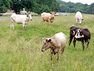
The village clusters around two roads: Calf Way and Honeycombe Road. Calf Way is thought to be a Roman road, presumably named for the cattle driven along it. Honeycombe Road leads to Honeycombe Farm, and then on to Miserden.
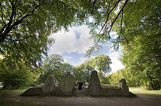
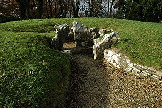
How the village came to be known as The Camp is a matter of debate. Some sources claim that it is related to Neolithic camps – and there are the remains of Neolithic burial chambers close to the village. Others claim that it was a Civil War encampment. In either case, at some point before 1767, the village was known as Hazlehouse-Yate.[2] Hazle House is a large house close to the village; "yate" means gate.
One of Neolithic barrows was opened in around 1720, and contained the skulls and skeletons of eight bodies.[3] Another barrow was opened a few years later – this one contained human bones and an urn, and was assumed to be Roman (the village is not far from Ermin Street, one of the great Roman roads).
Over the years, there have been a number of businesses in the village, some serving locals, and others finding customers further afield: the New Inn was the village pub until the 20th century; the village had a bakery; a quarry supplied roof tiles to the region; there were a number of farms; a motorbike garage servicing classic bikes; and there is still a thriving riding school.
The Camp currently has around 25 houses … of which 10 had been built by 1779.
↑ Rudder, S: A New History Of Gloucestershire, Page 553. Nonsuch Publishing, 2006. ISBN978-1-84588-023-1
Related Research Articles
The Cotswolds are an area in south central and south west England comprising the Cotswold Hills, a range of rolling hills that rise from the meadows of the upper Thames to an escarpment, known as the Cotswold Edge, above the Severn Valley and Evesham Vale. The area is defined by the bedrock of Jurassic limestone that creates a type of grassland habitat rare in the UK and that is quarried for the golden-coloured Cotswold stone. It contains unique features derived from the use of this mineral; the predominantly rural landscape contains stone-built villages, historical towns and stately homes and gardens.
Dursley is a market town and civil parish in southern Gloucestershire, England, situated almost equidistantly between the cities of Bristol and Gloucester. It is under the northeast flank of Stinchcombe Hill, and about 33⁄4 miles (6.0 km) southeast of the River Severn. The town is adjacent to Cam which, though a village, is a slightly larger community in its own right.
Stroud is a market town and civil parish in the centre of Gloucestershire, England. It is the main town in Stroud District.
A tumulus is a mound of earth and stones raised over a grave or graves. Tumuli are also known as barrows, burial mounds or kurgans, and may be found throughout much of the world. A cairn, which is a mound of stones built for various purposes, may also originally have been a tumulus.
Long barrows are a style of monument constructed across Western Europe in the fifth and fourth millennia BCE, during the Early Neolithic period. Typically constructed from earth and either timber or stone, those using the latter material represent the oldest widespread tradition of stone construction in the world. Around 40,000 long barrows survive today.
Corfe Mullen is a village in Dorset, England, on the north-western urban fringe of the South East Dorset conurbation and is part of the rural district of East Dorset. The village has a population of 10,133 (2011) and is served by six churches, four pubs, five schools, a library, various shops and local businesses, a village hall, and many community and sports organisations. There are three electoral wards within the village. In 2019, the Parish Councillors of the village voted to change the status of the village's Council to a Town Council, citing potential financial benefits. In all other aspects Corfe Mullen is still very much a village, albeit a large one.
Inkpen is a village and civil parish in West Berkshire 3.5 miles (5.6 km) southeast of Hungerford, most of the land of which is cultivated fields with scattered woodland which was once part of a former forest known as Savernake. Inkpen has boundaries with Wiltshire and Hampshire, including part of Walbury Hill, the highest point in England's South East.
The River Frome, once also known as the Stroudwater, is a small river in Gloucestershire, England. It is to be distinguished from another River Frome in Gloucestershire, the Bristol Frome, and the nearby River Frome, Herefordshire. The river is approximately 25 miles (40 km) long.
Frampton Cotterell is a village and parish, in South Gloucestershire, South West England, on the River Frome. The village is contiguous with Winterbourne to the south-west and Coalpit Heath to the east. The parish borders Iron Acton to the north and Westerleigh to the south-east, the large town of Yate is 2.1 miles (3.4 km) away. The village is 7.5 miles (12 km) north-east of the city of Bristol.
Uley is a village and civil parish in the county of Gloucestershire, England. The parish includes the hamlets of Elcombe and Shadwell. The village is situated in a wooded valley in the Cotswold escarpment, on the B4066 road between Dursley and Stroud. The placename probably signifies 'clearing in a yew wood'.
Old Sodbury is a small village in the valley of the River Frome just below and to the west of the Cotswold escarpment and to the east of Chipping Sodbury and Yate in South Gloucestershire, England. It is situated in the Hundred of Grumbald's Ash. The village extends from Chipping Sodbury in the West to the Cotswold Edge in the East and is on the Cotswold Way. The Badminton Road (A432) winds eastwards towards Badminton, Gloucestershire through the village, up to the Cross Hands junction with the A46, which runs along the top of the Cotswold escarpment from Bath to Stroud.
Arlingham is a village and civil parish in the Stroud District of Gloucestershire, England. The 2001 Census recorded a parish population of 410, increasing to 459 at the 2011 census. The parish contains the hamlets of Milton End, Overton and Priding The next parish to the east is Fretherne with Saul.
Barton Stacey is a village and undulating civil parish, which includes the hamlets of Bransbury, Newton Stacey, Drayton and Cocum, in the Test Valley district of Hampshire, England, centred about 7 miles (11 km) south-east of Andover. It is bounded to the north by the estate of Drayton Lodge, and, to the south, by the minor A30 road; both being east–west routes, and connected by The Street/Cocum Road, the main road that bisects the village. The distance between the A303 and A30 at this point is 2 miles (3.2 km), which is twice the width of the parish.
Selsley is a village within the civil parish of King's Stanley and district of Stroud, in Gloucestershire, England. It is composed of around 175 houses, scattered around the western and eastern edge of a Cotswold spur, located approximately 2 miles (3.2 km) south of Stroud.
Nympsfield is a village and civil parish in the English county of Gloucestershire. It is located around four miles south-west of the town of Stroud. As well as Nympsfield village, the parish contains the hamlet of Cockadilly. The population taken at the 2011 census was 382.
Birdlip is a village in Cotswold District of Gloucestershire in England, in the Cotswolds Area of Outstanding Natural Beauty, at an altitude of 287 m (940 ft), and about 6 miles (9.7 km) south of Cheltenham and 8 miles (13 km) south east of Gloucester.
Miserden is a village and civil parish in Stroud District, Gloucestershire, England, 4 miles north east of Stroud. The parish includes Whiteway Colony and the hamlets of Sudgrove and The Camp. In the 2001 census the parish had a population of 420, increasing to 449 at the 2011 census.
Nympsfield Long Barrow is the remains of a Neolithic burial site or barrow, located close to the village of Nympsfield in Gloucestershire, South West England.
Rough Bank, Miserden is a 9.2-hectare (23-acre) biological Site of Special Scientific Interest in Gloucestershire, notified in 1986. It was purchased by the wildlife charity Butterfly Conservation in 2012.
This page is based on this Wikipedia article Text is available under the CC BY-SA 4.0 license; additional terms may apply. Images, videos and audio are available under their respective licenses.