The Chevin

Last updated

The Chevin
Otleychevin.jpg
Viewpoint near the summit of Otley Chevin.
Highest point
Elevation 282 m (925 ft)
Geography
Location Wharfedale, overlooking Otley, West Yorkshire, England
OS grid SE204442
Topo map OS Landranger 104, OS Explorer 297
The Chevin overlooking Otley Otley.jpg
The Chevin overlooking Otley

The Chevin is the ridge on the south side of Wharfedale in Leeds, West Yorkshire, England, overlooking the market town of Otley, and often known as Otley Chevin.

Contents

Etymology

The origins of the name Chevin are uncertain; the earliest attestation is in an eleventh-century copy of a charter from 972 which gives the spelling scefinc, while a charter of around 1030 gives the form on Scefinge. The most probable origin, according to a range of authorities, is a Brittonic word whose modern Welsh descendant is cefn ("back", "ridge", "ridge of high land"). This word appears in other hill-names, such as Cefn Cribwr and Cefn Bryn in Glamorgan amongst many others in Wales, and also, it has been argued, The Cheviot in Northumberland, and the Cévennes in France. [1] [2] [3] :34–35

One of the steep hillsides of the Chevin is called the Great Dib, first attested in 1290 as Dibe. Since dib is a Middle English word for 'pool', this name probably originally referred to a pool at the foot of the slope. [3] :49

History and features

The Chevin is largely covered in attractive old woodland and heathland. It is a part of the Carboniferous Millstone Grit group. A Roman road ran along the top of the Chevin, part of the road that linked Eboracum (York), Calcaria (Tadcaster) and Olicana (Ilkley), perhaps on the same route as the modern road, Yorkgate, or perhaps about 800 metres (2,600 ft) to the south.

The highest point of the Chevin is often thought to be Surprise View, however it is in fact Beacon Hill next to Yorkgate quarry which reaches 283 metres (928 ft) at grid reference SE199441 [4] and used to be the site of a trig point. Surprise View is the more visited summit of the Chevin and offers extensive views of Otley and Wharfedale, and has an adjacent car park. It is the site of a cross erected every Easter since 1969. [5]

Parts of the Chevin, known as the Danefield Estate, belonged to landowner Walter Fawkes and his descendants. After World War II these areas were donated to Otley Urban District Council as a memorial to those from the Wharfe Valley who had lost their lives during the war. [6]

Recreation

A megalithic stone boundary on the Chevin below Surprise View Otley Chevin Megalithic Stone Boundary.jpg
A megalithic stone boundary on the Chevin below Surprise View

Several outcrops of rock are distributed across the upper slopes of the Chevin and are popular for climbing and bouldering. The Chevin also has a number of footpaths and bridlepaths, and is popular with walkers, runners and riders. It is crossed by the Leeds link to the Dales Way, [7] and the Ebor Way. There is also an Orienteering course in the forest park, with maps available from the local tourist office. Chevin Forest parkrun takes place at 9am every Saturday morning - it is a free, weekly, timed, 5 km run, organised by local volunteers. As a recreational area, the Chevin is divided in two by the East Chevin Road.

The Chevin in art

The famous painting Snow Storm: Hannibal and His Army Crossing the Alps by J. M. W. Turner which hangs in the Tate Gallery, is reputed to have been inspired by a view of the Chevin with a stormy background sky. Turner used to stay with his friend Walter Fawkes at Farnley Hall on the opposite side of the valley to the Chevin. Recalling a day in the autumn of 1810 Fawkes' son, Hawkesworth, remembered a storm that inspired one of Turner's major paintings:

"Hawkey! Hawkey! Come here! Come here! Look at this thunder-storm. Isn't it grand? isn't it wonderful? – isn't it sublime?" All this time he was making notes of its form and colour on the back of a letter. I proposed some better drawing-block, but he said it did very well. He was absorbed – he was entranced. There was the storm rolling and sweeping and shafting out its lightning over the Yorkshire hills. Presently the storm passed and he finished. "There Hawkey," said he, "In two years you will see this again, and call it Hannibal Crossing the Alps." [8]

Otley indie rock band The Chevin take their name from the hill.

Related Research Articles

<span class="mw-page-title-main">Guiseley</span> Town in West Yorkshire, England

Guiseley is a town in metropolitan borough of the City of Leeds, West Yorkshire, England. Historically part of the West Riding of Yorkshire, it is situated south of Otley and Menston and is now a north-western suburb of Leeds.

<span class="mw-page-title-main">River Wharfe</span> River in Yorkshire, England

The River Wharfe is a river in Yorkshire, England originating within the Yorkshire Dales National Park. For much of its middle course it is the county boundary between West Yorkshire and North Yorkshire. Its valley is known as Wharfedale.

<span class="mw-page-title-main">Otley</span> Market town and civil parish in West Yorkshire, England

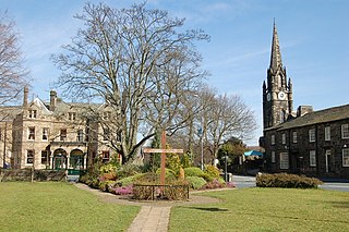
Otley is a market town and civil parish at a bridging point on the River Wharfe, in the City of Leeds metropolitan borough in West Yorkshire, England. Historically a part of the West Riding of Yorkshire, the population was 13,668 at the 2011 census. It is in two parts: south of the river is the historic town of Otley and to the north is Newall, which was formerly a separate township. The town is in lower Wharfedale on the A660 road which connects it to Leeds.

<span class="mw-page-title-main">Arthington</span> Village and civil parish in Leeds, West Yorkshire, England

Arthington is a linear village in Wharfedale, in the City of Leeds metropolitan borough in West Yorkshire, England. It is a civil parish which, according to the 2011 census, had a population of 532. It is in the Otley ward of the City of Leeds, and the Leeds North West parliamentary constituency.

<span class="mw-page-title-main">Wharfedale</span> Valley in Yorkshire, England

Wharfedale is the valley of the upper parts of the River Wharfe and one of the Yorkshire Dales. It is situated within the districts of Craven and Harrogate in North Yorkshire, and the cities of Leeds and Bradford in West Yorkshire. It is the upper valley of the River Wharfe. Towns and villages in Wharfedale include Buckden, Kettlewell, Conistone, Grassington, Hebden, Bolton Abbey, Addingham, Ilkley, Burley-in-Wharfedale, Otley, Pool-in-Wharfedale, Arthington, Collingham and Wetherby. Beyond Wetherby, the valley opens out and becomes part of the Vale of York.

<span class="mw-page-title-main">Cookridge</span> Suburb of Leeds in West Yorkshire, England

Cookridge is a suburb of north-west Leeds, West Yorkshire, England, north of the Leeds Outer Ring Road. In 1715 Ralph Thoresby described it as a village four miles from Leeds and three from Otley, dating from 1540.

<span class="mw-page-title-main">Bramhope</span> Village and civil parish in West Yorkshire, England

Bramhope is a village and civil parish in the City of Leeds metropolitan borough, West Yorkshire, England, north of Holt Park and north east of Cookridge.

<span class="mw-page-title-main">Burley in Wharfedale</span> Village and civil parish in West Yorkshire, England

Burley in Wharfedale is a village and a civil parish in the City of Bradford in West Yorkshire, England. It is situated in the Wharfedale valley.

<span class="mw-page-title-main">Meanwood Beck</span> Stream in West Yorkshire, England

The Meanwood Beck is a stream in West Yorkshire, England, which flows southwards through Adel, Meanwood and Sheepscar into the River Aire in central Leeds. Different portions of the same watercourse have been referred to as Adel Beck, Carr Beck, Lady Beck, Mabgate Beck, Sheepscar Beck, Timble Beck or Wortley Beck. The Meanwood Valley Trail footpath follows the line of the beck for much of its course.

<span class="mw-page-title-main">Lawnswood</span> Human settlement in England

Lawnswood is a small suburb in the north west of the city of Leeds in West Yorkshire, England. As such it is north north east of the West Yorkshire Urban Area. The suburb falls within the Adel and Wharefdale Ward of the City of Leeds Council.

<span class="mw-page-title-main">Prince Henry's Grammar School, Otley</span> Academy in Otley, West Yorkshire, England

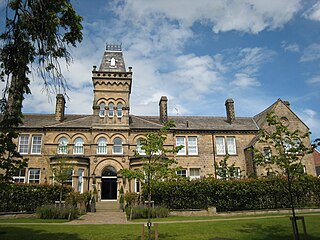
Prince Henry's Grammar School, also known as Prince Henry's or PHGS, is a secondary school and sixth form established in 1607 in the market town of Otley, West Yorkshire, England. The school teaches boys and girls between the ages of 11 and 18 and has around 1,400 pupils and 84 teachers. It retains a high position within regional league tables. In 2016 Prince Henry's had the third highest results for GCSEs in Leeds. Also in 2016 PHGS was the best state school in Leeds for A Level results. The school has repeatedly received a 'good' rating from Ofsted with outstanding features, however has in the past received criticism for the state of the old school building. Despite the name, Prince Henry's is now a state-funded academy school.

<span class="mw-page-title-main">Pool-in-Wharfedale</span> Village and civil parish in West Yorkshire, England

Pool-in-Wharfedale or Pool in Wharfedale, usually abbreviated to Pool, is a village and civil parish in Lower Wharfedale, West Yorkshire, England, 10 miles (16 km) north of Leeds city centre, 11 miles (18 km) north-east of Bradford, and 2 miles (3.2 km) east of Otley. It is in the City of Leeds metropolitan borough, and within the historic boundaries of the West Riding of Yorkshire.

<span class="mw-page-title-main">Walter Fawkes</span> Yorkshire landowner and MP (1769–1825)

Walter Ramsden Hawkesworth Fawkes was a Yorkshire landowner, writer and member of parliament (MP) for Yorkshire from 1806 to 1807.

<span class="mw-page-title-main">A660 road</span> Road in West Yorkshire, England

The A660 is a major road in the Leeds and Bradford districts of West Yorkshire, England that runs from Leeds city centre to Burley-in-Wharfedale where it meets the A65. The A660 is approximately 10 miles (16 km) long, and crosses the watershed from Airedale to lower Wharfedale. For most of its length the road is in the metropolitan district of the City of Leeds; the last 0.4 miles (0.6 km) is in City of Bradford district.

<span class="mw-page-title-main">Stainburn</span> Village and civil parish in North Yorkshire, England

Stainburn is a village and civil parish in the Harrogate district of North Yorkshire, England, 10 miles (16 km) north of Leeds. The population of the civil parish was estimated at 120 in 2015.

<span class="mw-page-title-main">Cefn Cyfarwydd</span> Hill in Conwy County Borough, Wales

Cefn Cyfarwydd is a ridge in Conwy county borough, north Wales. It is located above the village of Trefriw on the western side of the Conwy valley, and dramatically separates Cwm Cowlyd and the rugged mountains of the Carneddau from the greener, lusher Conwy valley.

<i>Snow Storm: Hannibal and his Army Crossing the Alps</i> Painting by J. M. W. Turner

Snow Storm: Hannibal and his Army Crossing the Alps is an oil on canvas painting by J. M. W. Turner, first exhibited in 1812. Left to the nation in the Turner Bequest, it was acquired by the National Gallery in London in 1856, and is now held by the Tate Gallery.

<span class="mw-page-title-main">Newall, West Yorkshire</span> Human settlement in England

Newall is an area of Otley in West Yorkshire, England. It lies on the north bank of the River Wharfe, across Otley Bridge from the central area of the town. The place-name, recorded in 1166 as Niuhale, simply means "New Hall".

References

  1. Speight, Harry (1900). Upper Wharfedale. p. 27.
  2. Ekwall, Eilert (1960). The Concise Oxford Dictionary of English Place-Names (4th ed.). Oxford: Clarendon Press. p. 102. ISBN   0198691033.
  3. 1 2 Harry Parkin, Your City's Place-Names: Leeds, English Place-Name Society City-Names Series, 3 (Nottingham: English Place-Name Society, 2017).
  4. TrigpointingUK, "trigpointing.uk", accessed 1 December 2020
  5. The Chevin Cross, otley.co.uk, accessed 24 June 2020
  6. Leeds City Council, Chevin Forest Park Otley, leaflet (undated)
  7. "Dales Way Association website". Archived from the original on 14 July 2007. Retrieved 23 September 2007.
  8. Thornbury, Walter (1862). The life of J.M.W.Turner. Oxford: Hurst and Blackett. pp. 87–88. (seen on Google Book Search)

53°53′37″N1°41′28″W / 53.89358°N 1.69107°W / 53.89358; -1.69107