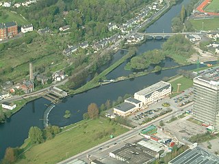
The Gearagh (Irish: An Gaorthadh)[2] is a submerged glacial woodland and nature reserve two kilometres southwest of Macroom, County Cork, in Kilmichael parish, Ireland. It is located at the point where the River Lee descends from the mountains and widens at an alluvial plain, and stretches for roughly five kilometres, bounded by the townlands of Toonsbridge, Illaunmore and Anahala.
It was until recently densely populated with ancient oak trees and the last surviving full oak forest in western Europe. Its Irish name is An Gaorthadh (meaning "the wooded river-valley" or "the river-bed"). [3] Author Seamus O'Donoghue provides another Irish name, An Gaoire, derived from the Irish word Gaorthadh.[4] The area was flooded in 1954 to facilitate the building of two hydro-electric dams in Carrigadrohid and Inniscarra, which provide electricity for the nearby city of Cork. The area is now part of the plants' upper reservoir. The development required the flooding of the region; consequently, hundreds of trees were felled and many people were relocated. Many of the trees were centuries old and had grown since the medieval period.[5] Today only their stumps survive, in flood land, giving the area a ghostly and almost lunar appearance.[4]
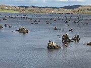
Today it comprises wide but shallow water enclosing a series of small islands separated by anastomosing, mostly flat, river streams.[6] It remains an area of outstanding natural beauty, with a diverse ecological system[5] and wide variety of plants, birds and fish, including freshwater pearl mussel, Atlantic salmon, whooper swans, kingfishers and otters.
The area is thought to have been wooded since the mid-Holocene[9] at the end of the last Ice Age, around 8,000 BC.[10] It is Ireland's last primeval river forest,[11] and is situated at the point where the River Lee emerges from the hills to broaden on alluvial ground.[4] Because of its fragmented, secluded and maze like structure, it was inaccessible to local Gardaí, and was traditionally a haven for poitín makers; the area was until recently renowned for its high quality, potent brand.[12]
Until the 1950s, it extended as far as the Lee Bridge and consisted of a large number of oak and ash trees.[13] It was gutted in 1954 during the construction of the Lee Valley hydro-electric plant, which necessitated extensive tree-felling and flooding. The trees, many of which were over many centuries old, were cut down and residents were relocated.[14] Now submerged houses are visible from the area around Two Mile Bridge. The scheme resulted in the loss of sixty percent of the former oak woodland.[10]
Local folklore associates the area with the Meascan Maraiocht, mischievous spirits that would deliberately confuse and lead visitors astray.[15][12]
The Gearagh is primarily of interest and importance due to its rich and rare diversity of wildlife, and it represents the only extant extensive alluvial woodland in Western Europe.[16] It hosts numerous rare plant species including marsh marigold, meadowsweet and nightshade,[4] and 62 species of moss and liverwort. While oak and ash trees once pre-dominated, today there are a number of willow and alder trees on the higher islands and inlets.[17] It hosts a large diversity of birds and wildfowl and attracts both summer and winter migrants. Examples include mallards, wigeon, Greylag geese, grey herons and coots.[4] It also hosts Atlantic salmon and the near extinct freshwater pearl mussel. The area is protected under the international Ramsar Convention.
The area has been the focus of significant heritage and conservation efforts, especially by environmental biologist and conservationist Kevin Corcoran. He observed that before the dam was built "this was the last pure stand of ancient riverine forest that had survived intact since the last ice age. This was just one of four such systems on the whole planet."[14] Describing the Gearagh as of "immense" importance, Corcoran observed in a later interview how it is "hard to imagine what the area looked like before being flooded – a vast inland delta of inter-connecting, many branched streams that encircled a maze of small and inaccessible islands, covered in oak forest. It was protected from the ravages of humanity by its swampy terrain, deep swirling streams and treacherous banks of soft mud with holes big enough to swallow a horse."[18]
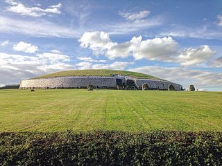
According to filmmaker Declan O’Mahony, "If the water level was permanently dropped,[19] the Gearagh would grow back and has the full potential to become a world heritage site on a par with Newgrange, the Giant’s Causeway and The Burren". (The Burren is not actually a World Heritage Site, although it has been put forward as a candidate.).[20]
The Gearagh was declared a statutory nature reserve in 1987, under the protection of the Wildlife Act, but owned by the ESB.
Gallery
The main pathway; the remnants of the old Port road, which cross mid way along the length of the Gearagh, and consists of a series of bridges.[4]
Brown, A.G. lluvial Geoarchaeology: Floodplain Archaeology and Environmental Change. Cambridge University Press, 2008. ISBN978-0-5215-6820-3
Corcoran, Kevin. Saving Eden: The Gearagh and Irish Nature. Cork: The Gearagh Press, 2021. ISBN978-1-78846-194-8
Monk, Michael. Early Medieval Munster: Archaeology, History and Society. Cork: Cork University Press, 1998. ISBN978-1-8591-8107-2
O'Donoghue, Seamus. The Flooding of the Lee Valley: The Lee Hydro-electric Scheme. Cork: Tower Books, 1996. ISBN0-9025-6826-4
Wood, Paul. Hydroecology and Ecohydrology: Past, Present and Future. Wiley & sons, 2007. ISBN978-0-4700-1017-4
Related Research Articles
Newgrange is a prehistoric monument in County Meath in Ireland, located on a rise overlooking the River Boyne, 8 kilometres (5.0 mi) west of Drogheda. It is an exceptionally grand passage tomb built during the Neolithic Period, around 3200 BC, making it older than Stonehenge and the Egyptian pyramids. It is aligned on the winter solstice sunrise. Newgrange is the main monument in the Brú na Bóinne complex, a World Heritage Site that also includes the passage tombs of Knowth and Dowth, as well as other henges, burial mounds and standing stones.
Macroom is a market town in County Cork, Ireland, located in the valley of the River Sullane, halfway between Cork city and Killarney. Its population has grown and receded over the centuries as it went through periods of war, famine and workhouses, forced emigration and intermittent prosperity. The 2011 census gave an urban population of 3,879 people, while the 2016 census recorded 3,765 people.
Coachford is a village in County Cork, Ireland. It is located on the north side of the River Lee. The village is located in the civil parish of Magourney. Coachford is part of the Dáil constituency of Cork North-West.
The River Lee is a river in Ireland. It rises in the Shehy Mountains on the western border of County Cork and flows eastwards through Cork, where it splits in two for a short distance, creating an island on which Cork's city centre is built, then passing through Cork Harbour on the south coast, one of the largest natural harbours in the world, to empty into the Celtic Sea. The catchment area of the River Lee is 1,253 km2. The long-term average flow rate of the River Lee is 40.4 cubic metres per second (m3/s)
The Peace–Athabasca Delta, located in northeast Alberta, is the largest freshwater inland river delta in North America. It is located partially within the southeast corner of Wood Buffalo National Park, Canada's largest national park, and also spreads into the Regional Municipality of Wood Buffalo, west and south of the historical community of Fort Chipewyan. The delta encompasses approximately 321,200 ha, formed where the Peace and Athabasca rivers converge on the Slave River and Lake Athabasca. The delta region is designated a wetland of international importance and a UNESCO World Heritage Site. The region is large enough that it is considered one of twenty distinct natural subregions of Alberta by the provincial government's Natural Regions Committee.
Brú na Bóinne or Boyne valley tombs, is an area in County Meath, Ireland, located in a bend of the River Boyne. It contains one of the world's most important prehistoric landscapes dating from the Neolithic period, including the large Megalithic passage graves of Knowth, Newgrange and Dowth as well as some 90 additional monuments. The archaeological culture associated with these sites is called the "Boyne culture".
Ballyvourney is a Gaeltacht village in southwest County Cork, Ireland. It is a civil parish in the barony of Muskerry West, and is also an ecclesiastical parish in the Roman Catholic Diocese of Cloyne. Ballyvourney is part of the Cork North-West Dáil Constituency.
Apalachee Bay is a bay in the northeastern Gulf of Mexico occupying an indentation of the Florida coast to the west of where the Florida peninsula joins the United States mainland. It is bordered by Taylor, Jefferson, Wakulla, and Franklin counties.
The Carrigrohane Straight is a straight segment of road that stretches for 2.75 miles (4.43 km), from the edge of Cork west to Carrigrohane in County Cork, Ireland. It is just over 140 years old, and now forms part of the N22 National Primary route between Cork and Tralee.
Dripsey is a village in County Cork on the R618 regional road around 20 km (12 mi) west of Cork City. It is situated on a tributary of the River Lee, the Dripsey River. It is in the Catholic parish of Inniscarra. The Dripsey area hosts a water treatment plant, the Cork offices of the Environmental Protection Agency, and an award-winning garden center. The village has one pub, a primary school and a pre-school.
Farran is a village in County Cork, Ireland, in the parish of Ovens. It lies on the southside of the River Lee. Farran is 12 miles (19 km) west from Cork City on the N22 road.
Derwent Ings is a Site of Special Scientific Interest (SSSI) divided between North Yorkshire and the East Riding of Yorkshire, England. Derwent Ings is of international significance and has been designated a Wetland of International Importance under the Ramsar Convention and as a Special Protection Area under the terms of the European Community Directive. Part of the site is owned by the Yorkshire Wildlife Trust and is managed in conjunction with English Nature. It lies adjacent to the River Derwent between Sutton upon Derwent and Menthorpe. The site, which was designated a SSSI in 1975, consists of a series of neutral alluvial flood meadows, fen and swamp communities and freshwater habitats. It is one of the most important examples of agriculturally unimproved species-rich alluvial flood meadow habitat remaining in the UK.
Muskerry West is one of the baronies of Ireland, a historical geographical unit of land. Its chief town is Macroom. It is one of 24 baronies in the county of Cork. It may also be viewed as a half barony because sometime before the 1821 census, it was divided from its other half – Muskerry East. Other neighbouring baronies include Duhallow to the north and the Barony of Carbery East to the south.
Inniscarra is a civil parish in the barony of Muskerry East, County Cork, Ireland. It is located about 15km west of Cork city. The local GAA club is Inniscarra GAA and Dripsey GAA. Inniscarra is located on the north side of the River Lee. Inniscarra Dam is one of the two Hydro-Electric Dams on the River Lee.
Newtown Castle is a 16th-century tower house, located close to the village of Ballyvaughan within the Burren area of County Clare, Ireland. Uniquely for a tower house of its type in Ireland, Newtown Castle is mostly cylindrical in shape but rises from a square pyramidical base. It is today part of the Burren College of Art.
Carrignamuck Tower House, located in Carrignamuck townland, is situated 2.8 km (1.7 mi) north of Coachford village and 2 km (1.2 mi) north-west of Dripsey village. It is also known as 'Dripsey Castle,' a name more properly attributed to nearby Dripsey Castle, Carrignamuck.
Inchigeelagh is a small village, townland and civil parish in County Cork, Ireland. The village is just outside a Gaeltacht area. Inchigeelagh is part of the Cork North-West.
Inniscarra Lake is located along the River Lee in County Cork, Ireland. It is a man-made reservoir formed in the 1950s when Inniscarra Dam was constructed by the Electricity Supply Board. Construction of the dam commenced in 1953, with its floodgates first closed in 1956 and the reservoir fully formed by late 1957.
The R584 road is a regional road in Ireland. It is a road in west County Cork.
Carrigadrohid hydroelectric power station is a hydroelectric plant located on the River Lee in County Cork, Ireland. It is owned and operated by the ESB Group. The dam is 130 m (427 ft) long and has a single 8 MW (11,000 hp) Kaplan turbine which produces an average of 22 GWh (79 TJ) each year. Built between 1952 and 1957. the construction of Carrigadrohid required the destruction of over half of the Gearagh, an ancient alluvial forest, and initially harmed local wildlife. However, subsequently the area has seen the growth of an ecosystem with kingfishers, otters, salmon and swans, which has been designated European Union Special Area of Conservation.
This page is based on this Wikipedia article Text is available under the CC BY-SA 4.0 license; additional terms may apply. Images, videos and audio are available under their respective licenses.