
Bridgwater is a historic market town and civil parish in Somerset, England. The town had a population of 41,276 at the 2021 census. Bridgwater is at the edge of the Somerset Levels, in level and well-wooded country. The town lies along both sides of the River Parrett; it has been a major inland port and trading centre since the industrial revolution. Most of its industrial bases still stand today. Its larger neighbour, Taunton, is linked to Bridgwater via a canal, the M5 motorway and the GWR railway line.

Ilchester is a village and civil parish, situated on the River Yeo or Ivel, five miles north of Yeovil, in the English county of Somerset. Originally a Roman town, and later a market town, Ilchester has a rich medieval history and was a notable settlement in the county; around the 12th and 13th centuries it was effectively the county town. It had, however, declined in size and importance by the beginning of the 18th century, and the last markets were held in 1833. In 1889 the historic corporation that had governed the town was dissolved.

Somerton is a town and civil parish in the English county of Somerset. It gave its name to the county and was briefly, around the start of the 14th century, the county town, and around 900 was possibly the capital of Wessex. It has held a weekly market since the Middle Ages, and the main square with its market cross is today popular with visitors. Situated on the River Cary, approximately 8.8 miles (14.2 km) north-west of Yeovil, Somerton has its own town council serving a population of 4,697 as of 2011.
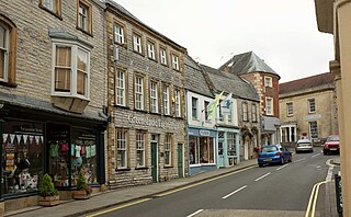
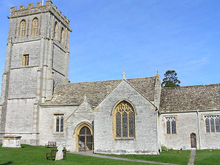
Langport is a town and civil parish in Somerset, England, 5 miles (8 km) west of Somerton. The parish, which covers only part of the town, has a population of 3,578. Langport is contiguous with Huish Episcopi, a separate parish that includes much of the town's outskirts.
Wiveliscombe is a town and civil parish in Somerset, England, situated 9 miles (14 km) west of Taunton. The town has a population of 2,893. The Square, fronted by several listed structures, held the former market. The parish includes the nearby hamlet of Maundown.

Curry Rivel is a village and civil parish in Somerset, England, situated 6 miles (9.7 km) west of Somerton and 10 miles (16.1 km) east of Taunton in the South Somerset district. The parish has a population of 2,148. The parish includes the hamlet of Burton Pynsent.
Drayton is a village and civil parish in Somerset, England, focussed less than a mile from Curry Rivel and five miles southwest of Somerton in the South Somerset district. It adjoins the River Isle, near its confluence with the Parrett, and the former Westport Canal. The parish includes the hamlet of Midelney.

High Ham is a village and civil parish in Somerset, England. Within the parish of High Ham, there are the villages of High Ham and Low Ham and the hamlets of Bowdens, Henley, Paradise and Picts Hill.
Huish Episcopi is a village and civil parish in Somerset, England, situated on the outskirts of Langport, 4 miles (6.4 km) south west of Somerton. The parish has a population of 2,644, and includes the hamlets of Bowdens, Combe, Pibsbury and Wearne.
Kingsdon is a village and parish in the South Somerset district of Somerset, England, situated 3 miles (4.8 km) south east of Somerton. The village has a population of 303 but this is set to rise to around 350 once the Kingsdon Manor development is complete. The majority of the houses in the village are clustered on the side of the hill from which there are scenic views across the Somerset countryside.

Kingweston is a village and civil parish in Somerset, England, situated on Combe Hill, 3 miles (4.8 km) north east of Somerton in the South Somerset district. The village has a population of 128.

Milborne Port is a village, electoral ward and civil parish in Somerset, England, east of Sherborne, and in the South Somerset district. It has a population of 2,802. The parish includes the hamlets of Milborne Wick and Kingsbury Regis.

Blagdon is a village and civil parish in the ceremonial county of Somerset, within the unitary authority of North Somerset, in England. It is located in the Mendip Hills, a recognised Area of Outstanding Natural Beauty. According to the 2021 census it has a population of 1,184. The village is about 12 miles (19 km) east of Weston-super-Mare and 12 miles (19 km) south west of Bristol, on the A368 road to Bath.

Pitney is a village and parish in Somerset, England, located 2.5 miles (4.0 km) east of Langport and 3 miles (4.8 km) west of Somerton in the South Somerset district. In 2011, the village had a population of 374.

Middlezoy is a village and civil parish on the Somerset Levels in Somerset, England. Situated between the two other villages of Westonzoyland and Othery and is about six miles from the town of Bridgwater which is on the tidal river Parret.
Rimpton is a village and civil parish 5 miles (8 km) north-west of Sherborne, and 6 miles (10 km) north-east of Yeovil on a tributary of the River Parret in the South Somerset district of Somerset, England.

John Thomas Quekett was an English microscopist and histologist.

The Grade I listed buildings in Somerset, England, demonstrate the history and diversity of its architecture. The ceremonial county of Somerset consists of a non-metropolitan county, administered by Somerset County Council, which is divided into five districts, and two unitary authorities. The districts of Somerset are West Somerset, South Somerset, Taunton Deane, Mendip and Sedgemoor. The two administratively independent unitary authorities, which were established on 1 April 1996 following the breakup of the county of Avon, are North Somerset and Bath and North East Somerset. These unitary authorities include areas that were once part of Somerset before the creation of Avon in 1974.
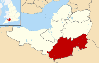
South Somerset is a local government district in the English county of Somerset. The South Somerset district occupies an area of 370 square miles (958 km2), stretching from its borders with Devon and Dorset to the edge of the Somerset Levels. The district has a population of about 158,000, and has Yeovil as its administrative centre.

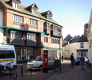
Langport Town Hall is a municipal building in Bow Street in Langport, Somerset, England. The building, which is the meeting place of Langport Town Council, is a Grade II listed building.

