Related Research Articles

Peat is an accumulation of partially decayed vegetation or organic matter. It is unique to natural areas called peatlands, bogs, mires, moors, or muskegs. Sphagnum moss, also called peat moss, is one of the most common components in peat, although many other plants can contribute. The biological features of sphagnum mosses act to create a habitat aiding peat formation, a phenomenon termed 'habitat manipulation'. Soils consisting primarily of peat are known as histosols. Peat forms in wetland conditions, where flooding or stagnant water obstructs the flow of oxygen from the atmosphere, slowing the rate of decomposition. Peat properties such as organic matter content and saturated hydraulic conductivity can exhibit high spatial heterogeneity.

The North York Moors is an upland area in north-eastern Yorkshire, England. It contains one of the largest expanses of heather moorland in the United Kingdom. The area was designated as a National Park in 1952, through the National Parks and Access to the Countryside Act 1949. Covering an area of 554 sq mi (1,430 km2), the National Park has a population of 23,380. It is administered by the North York Moors National Park Authority, whose head office is based in Helmsley.

A bog or bogland is a wetland that accumulates peat as a deposit of dead plant materials – often mosses, typically sphagnum moss. It is one of the four main types of wetlands. Other names for bogs include mire, mosses, quagmire, and muskeg; alkaline mires are called fens. A bayhead is another type of bog found in the forest of the Gulf Coast states in the United States. They are often covered in heath or heather shrubs rooted in the sphagnum moss and peat. The gradual accumulation of decayed plant material in a bog functions as a carbon sink.

Sphagnum is a genus of approximately 380 accepted species of mosses, commonly known as sphagnum moss, also bog moss and quacker moss. Accumulations of Sphagnum can store water, since both living and dead plants can hold large quantities of water inside their cells; plants may hold 16 to 26 times as much water as their dry weight, depending on the species. The empty cells help retain water in drier conditions.

Mer Bleue Bog is a 33.43 km2 (12.91 sq mi) protected area in Gloucester, Ontario, an eastern suburb of Ottawa in Eastern Ontario, Canada. Its main feature is a sphagnum bog that is situated in an ancient channel of the Ottawa River and is a remarkable boreal-like ecosystem normally not found this far south. Stunted black spruce, tamarack, bog rosemary, blueberry, and cottongrass are some of the unusual species that have adapted to the acidic waters of the bog.

The High Fens, which were declared a nature reserve in 1957, are an upland area, a plateau region in Liège Province, in the east of Belgium and adjoining parts of Germany, between the Ardennes and the Eifel highlands. The High Fens are the largest nature reserve or park in Belgium, with an area of 4,501.2 ha ; it lies within the German-Belgian natural park Hohes Venn-Eifel, in the Ardennes. Its highest point, at 694 metres (2,277 ft) above sea level, is the Signal de Botrange near Eupen, and also the highest point in Belgium. A tower 6 metres (20 ft) high was built here that reaches 700 metres (2,297 ft) above sea level. The reserve is a rich ecological endowment of Belgium covered with alpine sphagnum raised bogs both on the plateau and in the valley basin; the bogs, which are over 10,000 years old, with their unique subalpine flora, fauna and microclimate, are key to the conservation work of the park.

Burns Bog is an ombrotrophic peat bog located in Delta, British Columbia, Canada. It is the largest raised peat bog and the largest undeveloped urban land mass on the West Coast of the Americas. Burns Bog was originally 4,000–4,900 hectares before development. Currently, only 3,500 hectares remain of the bog.

Cranberry Glades—also known simply as The Glades—are a cluster of five small, boreal-type bogs in southwestern Pocahontas County, West Virginia, United States. This area, in the Allegheny Mountains at about 3,400 feet (1,000 m), is protected as the Cranberry Glades Botanical Area, part of the Monongahela National Forest. This site is the headwaters of the Cranberry River, a popular trout stream, and is adjacent to the nearly 50,000-acre (200 km2) Cranberry Wilderness.
Nathaniel Mountain is a mountain ridge that runs southwest northeast through Hampshire County in West Virginia's Eastern Panhandle, rising to its greatest elevation of 2,739 feet (835 m) above sea-level. The mountain is bound at its western flank by the South Branch Potomac River and to its eastern flank by South Branch Mountain 3,028 feet (923 m). The bulk of Nathaniel Mountain is located within the Nathaniel Mountain Wildlife Management Area (WMA) owned by the West Virginia Division of Natural Resources.
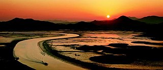
Suncheon Bay Ecological Park is a protected natural area near Suncheon, South Korea. It is a bay between Yeosu and Goheung peninsulas, located 8 km (5.0 mi) from the center of Suncheon, with 21.6 km2 (8.3 sq mi) of mudflats and 5.4 km2 (2.1 sq mi) of reed beds.
Mulyeongari-oreum is a lake and wetland located on Jeju island. It is the only wetland in Korea which is located within a volcanic crater in a parasitic cone, called an oreum in the Jeju dialect of Korean. The oreum is one of the secondary volcanoes around the Hallasan volcano, which is the highest mountain in South Korea. Through continuing scientific research, it is thought that Mulyeongari-oreum was formed by volcanic activity continuing for 2,500 years at the end of the third Cenozoic Era on Jeju Island. On top of the oreum, there is a shallow crater lake which displays a unique example of a wetland. The level of water changes with the seasons due to rainfall and the particular geology. Some 370 parasitic cones are located around Hallasan. Only about 30% of them have mountain craters. The geology is mostly composed of water-permeable basalt, so it is unusual to have a lake on top of such volcanic cones. During the dry season, most of wetland becomes dries out, except the deepest part in the south. During the rainy season, most of it is submerged.
Moojechineup is a high moor located on Mt. Jeongjok in Ulsan, Korea. The name 'Mooje' came from a ritual praying for rain. Mooejechipneup has an area of 4 hectares, and it is composed of 4 swamps: first at 510m above sea level, second at 558m, and third and fourth at 630m. As a 6,000-year-old high moor, it is known to be the oldest high moor in Korea, and there are so many different fauna and flora species living at Moojechinuep. It was registered as a Ramsar Wetlands on December 20, 2007 and became the 7th Ramsar Wetlands in Korea.
Odaesan (also known as Mt. Odae) is located in the Taebaek Mountains, the longest mountain range in Korea. It is named Odaesan because it has five big mountain peaks (O means "five" in Korean). Odaesan National Park Wetlands has an area of 1.7 hectares and consists of three small fens: Jilmoeneup, Sohwangbyeongsanneup, and Jogaedongneup. This site was registered as a Ramsar Wetlands on October 13, 2008, at the 10th Ramsar Convention.

Kolkheti National Park, is a national park located in Samegrelo-Zemo Svaneti and Guria in the historical region of Colchis in western Georgia. The wetlands of Central Kolkheti are a Wetland of International Importance, a Ramsar Site. It lies on a coastal plain on the Black Sea, between the mouths of the Tikori and Supsa and spanning the districts of Zugdidi, Khobi, Lanchkhuti, Senaki and Abasha. The park was established during 1998 and 1999 as part of Georgia's Integrated Coastal Management Project, which was backed financially by the World Bank (WB) and the Global Environmental Facility (GEF). Kolkheti National Park covers an area of 28,940 hectares and with protected wetlands protected area spans to 33710 hectares, incorporating the land of the former 500-hectare Kolkheti State Nature Reserve, which had been established in 1947, and its surrounding wetlands, including the lake Paliastomi. Because of its unique forests and wetlands, and high numbers of threatened species, the park was inscribed on the UNESCO World Heritage List as part of the Colchic Rainforests and Wetlands site in 2021.

The Djibouti Xeric Shrublands ecoregion is a semi-desert strip on or near the Red Sea and the Gulf of Aden coasts in Eritrea, Ethiopia, Djibouti and Somalia. This ecoregion lies mainly between sea level and 800 meters (m) elevation. There are, however, many hills and massifs, which range up to 1300 m as well as outstanding fault-induced depressions, such as the Danakil, lying as low as 155 m below sea level. This region is extremely active tectonically, experiencing many earthquakes and intermittently active volcanoes. Rainfall is very low and yearly averages range from 100 to 200 millimeters (mm), with less rain falling closer to the coast. There are many species of interest, including the endemic Archer's lark, a species of dragon tree, and a large suite of desert ungulates, including the last viable population of African wild ass.
The Ginini Flats Wetlands Ramsar Site, also known as the Ginini Flats Subalpine Bog Complex, is a wetland in the Australian Capital Territory (ACT) that has been recognised as being of international importance by designation under the Ramsar Convention. It was listed on 11 March 1996 as Ramsar Site 793, and is the only such site in the ACT. It lies in the Australian Alps, close to the boundary of the ACT with New South Wales.

Meshchyora National Park covers extensive wetlands and pine/birch woodlands in the Meshchera Lowlands on the East European Plain in Vladimir Oblast, about 120 km east of Moscow. The wetland habitat provides for extremely rich biodiversity among the plants and animals. The area is associated with the medieval Meshchera tribe, from which the area takes its name. "Meshchyora" National Park (Мещёра) is not to be confused with "Meshchersky" (Мещёрский) National Park, which is just to the south, over the border in Ryazan Oblast. The Meshchyora NP is located entirely within the Oka River watershed. A small corner of the park touches on the border of the Moscow region. About 39% of the park territory is used and managed for agricultural purposes by local communities.

Meshchyorsky National Park covers extensive wetlands and pine/birch woodlands in the Meshchera Lowlands on the East European Plain in the northern section of Ryazan Oblast, Russia, about 120 km east of Moscow. The wetland habitat provides for extremely rich biodiversity among the plants and animals. "Meshchersky" (Мещёрский) National Park is not to be confused with "Meshchyora" (Мещёра) National Park, which is just to the north, over the border in Vladimir Oblast. The park protects a section of the Pra River, Lake Beloye, and associated wetlands and forests. About 54% of the park territory is used and managed for agricultural purposes by local communities.

Kobuleti Strict Nature Reserve is a protected area in Kobuleti Municipality, Adjara region of Georgia along the Black Sea coast in the northern part of the resort town Kobuleti. Kobuleti Protected Areas were established in 1998 to preserve unique wetland ecosystems recognized by the Ramsar Convention. Because of these wetland ecosystems, ancient forests, and the high biodiversity found within the reserve, it was inscribed on the UNESCO World Heritage List as part of the Colchic Rainforests and Wetlands in 2021.
References
- ↑ "The High Moor, Yongneup of Mt. Daeam". Ramsar Sites Information Service. Retrieved 25 April 2018.
'Finding Wetland' by Ministry of Environment Republic of Korea