The Leap, Queensland

Last updated

The Leap
Queensland
Australia Queensland location map.svg
Red pog.svg
The Leap
Coordinates 21°03′50″S149°01′22″E / 21.0638°S 149.0227°E / -21.0638; 149.0227 (The Leap (centre of locality))
Population664 (2021 census) [1]
 • Density11.986/km2 (31.04/sq mi)
Postcode(s) 4740
Area55.4 km2 (21.4 sq mi)
Time zone AEST (UTC+10:00)
Location
LGA(s) Mackay Region
State electorate(s) Whitsunday
Federal division(s) Dawson
Suburbs around The Leap:
Mount Jukes Coral Sea Habana
Kuttabul The Leap Habana
Hampden Balnagowan Farleigh

The Leap is a coastal rural locality in the Mackay Region, Queensland, Australia. [2] In the 2021 census, The Leap had a population of 664 people. [1]

Contents

Geography

The locality is bounded to the north-west by Constant Creek and to the north by its mouth ( 21°00′00″S149°01′00″E / 21.0000°S 149.0167°E / -21.0000; 149.0167 (Constant Creek (mouth)) ) into the Coral Sea. [3] Sand Bay is offshore ( 20°57′00″S149°03′13″E / 20.95000°S 149.0536°E / -20.95000; 149.0536 (Sand Bay) ). [4] [5] [6]

The locality has a number of named peaks, including:

There is a section of the Pioneer Peaks National Park in the centre of the locality. To the immediate west and south of the national park are areas of rural residential housing. The land use in the rest of the locality is a mixture of grazing and crop growing (predominantly sugarcane). [6]

The Bruce Highway enters the locality from the south-east (Farleigh) and exits to the south-west (Hampden). The North Coast railway line follows a similar route to the north of the highway but there are no railway stations on that line serving the locality. [6] There is a network of cane tramways in the locality to transport the harvested sugarcane to the sugar mill for processing. [10]

History

The Leap is named for a historical event in which it is widely believed an Aboriginal woman carrying her daughter leapt off a cliff to evade capture by the Queensland Native Police circa 1860. The woman died but her daughter survived. [11]

The Leap Provisional School opened on 13 March 1893. On 1 January 1909, it became The Leap State School. In 1919, Arthur Edward Hunter (of The Leap Hotel) donated 1.1786 hectares (2.912 acres) of land for the school. [12] The school closed on 8 August 1969. [13] As the land had been donated for school purposes, the usual practice was that the land was returned to the donor or their heirs. Two people made claims to be Hunter's relatives, but the Queensland Government did not find the claims to be proven and decided in 1988 to sell the land and kept the proceeds. [12] The school was at 2105 Maraju Yakapari Road ( 21°04′12″S149°00′30″E / 21.0700°S 149.00847°E / -21.0700; 149.00847 (The Leap State School (former)) ). [14] [15] [6]

The North Coast railway line reached The Leap in 1924, [ citation needed ] with the area being served by the following now-abandoned stations (from south to north):

Demographics

In the 2011 census, The Leap had a population of 673 people. [16]

In the 2016 census, The Leap had a population of 642 people. [17]

In the 2021 census, The Leap had a population of 664 people. [1]

Heritage listings

The Leap cane lift, 2011 The Leap Cane Lift (derrick), 2011.jpg
The Leap cane lift, 2011

The Leap has a number of heritage-listed sites, including:

Education

There are no schools in The Leap. The nearest government primary schools are Coningsby State School and Farleigh State School, both in neighbouring Fairleigh to the south-east. The nearest government secondary school are Mackay Northern Beaches State High School in Rural View to the east and Mackay North State High School in North Mackay to the south-east. [19]

Attractions

A sculpture representing the Aboriginal woman who jumped from the cliff was erected outside a local hotel in the area. [20]

Related Research Articles

<span class="mw-page-title-main">Sarina, Queensland</span> Town in Queensland, Australia

Sarina is a rural town and coastal locality in the Mackay Region, Queensland, Australia. In the 2021 census, the locality of Sarina had a population of 5,619 people.

<span class="mw-page-title-main">Calen, Queensland</span> Town in Queensland, Australia

Calen is a rural town and coastal locality in the Mackay Region, Queensland, Australia. In the 2016 census, the locality of Calen had a population of 390 people.

<span class="mw-page-title-main">Carmila, Queensland</span> Town in Queensland, Australia

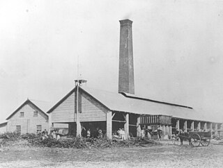
Carmila is a rural town and coastal locality in the Isaac Region, Queensland, Australia. In the 2016 census, the locality of Carmila had a population of 333 people.

Te Kowai is a rural locality in the Mackay Region, Queensland, Australia. In the 2021 census, Te Kowai had a population of 227 people.

<span class="mw-page-title-main">Mirani, Queensland</span> Town in Queensland, Australia

Mirani is a rural town and locality in the Mackay Region, Queensland, Australia. In the 2016 census, the locality of Mirani had a population of 1,541 people.

Koumala is a rural town and coastal locality in the Mackay Region, Queensland, Australia. In the 2016 census, the locality of Koumala had a population of 831 people.

<span class="mw-page-title-main">Mount Jukes, Queensland</span> Suburb of Mackay Region, Queensland, Australia

Mount Jukes is a mountain and surrounding coastal rural locality north of Mackay in the Mackay Region, Queensland, Australia. In the 2021 census, Mount Jukes had a population of 373 people.

<span class="mw-page-title-main">Alexandra, Queensland</span> Suburb of Mackay, Queensland, Australia

Alexandra is a suburb of Mackay in the Mackay Region, Queensland, Australia. In the 2021 census, Alexandra had a population of 189 people.

<span class="mw-page-title-main">Habana, Queensland</span> Suburb of Mackay Region, Queensland, Australia

Habana is a coastal rural locality in the Mackay Region, Queensland, Australia. In the 2021 census, Habana had a population of 1,022 people.

Hampden is a rural locality in the Mackay Region, Queensland, Australia. In the 2021 census, Hampden had a population of 598 people.

Chelona is a rural locality in the Mackay Region, Queensland, Australia. In the 2021 census, Chelona had a population of 120 people.

Ooralea is a southern suburb of Mackay in the Mackay Region, Queensland, Australia. In the 2016 census, Ooralea had a population of 3,366 people.

Paget is a coastal suburb of Mackay in the Mackay Region, Queensland, Australia. In the 2016 census, Paget had a population of 273 people.

<span class="mw-page-title-main">Mackay Harbour, Queensland</span> Suburb of Mackay, Queensland, Australia

Mackay Harbour is a coastal mixed-use locality in the Mackay Region, Queensland, Australia. In the 2021 census, Mackay Harbour had a population of 686 people.

Freshwater Point is a coastal locality in the Mackay Region, Queensland, Australia. In the 2021 census, Freshwater Point had a population of 174 people.

Sarina Beach is a coastal town and locality in the Mackay Region, Queensland, Australia. In the 2016 census, the locality of Sarina Beach had a population of 607 people.

<span class="mw-page-title-main">Grasstree Beach, Queensland</span> Suburb of Mackay Region, Queensland, Australia

Grasstree Beach is a coastal locality in the Mackay Region, Queensland, Australia. It contains two towns, Grasstree in the centre of the locality and Zelma on the coast. In the 2021 census, Grasstree Beach had a population of 717 people.

<span class="mw-page-title-main">Foulden, Queensland</span> Suburb of Mackay, Queensland, Australia

Foulden is a rural locality in the Mackay Region, Queensland, Australia. It is on the northern bank of the Pioneer River in Mackay. In the 2021 census, Foulden had "no people or a very low population".

Erakala is a mixed-use locality in the Mackay Region, Queensland, Australia. In the 2021 census, Erakala had a population of 763 people.

Mackay is the central suburb and the central business district of the City of Mackay in the Mackay Region, Queensland, Australia. In the 2021 census, the suburb of Mackay had a population of 4,026 people.

References

  1. 1 2 3 Australian Bureau of Statistics (28 June 2022). "The Leap (SAL)". 2021 Census QuickStats. Retrieved 28 February 2023. OOjs UI icon edit-ltr-progressive.svg
  2. "The Leap – locality in Mackay Region (entry 46844)". Queensland Place Names. Queensland Government . Retrieved 27 December 2020.
  3. "Constant Creek – watercourse in the Mackay Region (entry 7980)". Queensland Place Names. Queensland Government . Retrieved 20 March 2021.
  4. "Bays - Queensland". Queensland Open Data. Queensland Government. 12 November 2020. Archived from the original on 25 November 2020. Retrieved 25 November 2020.
  5. "Sand Bay – bay in the Mackay Region (entry 29571)". Queensland Place Names. Queensland Government . Retrieved 20 March 2021.
  6. 1 2 3 4 "Queensland Globe". State of Queensland . Retrieved 19 November 2023.
  7. 1 2 3 "Mountain peaks and capes - Queensland". Queensland Open Data. Queensland Government. 12 November 2020. Archived from the original on 25 November 2020. Retrieved 25 November 2020.
  8. "The Leap – mountain in Mackay Region (entry 34007)". Queensland Place Names. Queensland Government . Retrieved 25 November 2020.
  9. "The Sister – mountain in Mackay Region (entry 34110)". Queensland Place Names. Queensland Government . Retrieved 25 November 2020.
  10. 1 2 3 4 5 "Railway stations and sidings - Queensland". Queensland Open Data. Queensland Government. 2 October 2020. Archived from the original on 5 October 2020. Retrieved 5 October 2020.
  11. "Instagram-friendly signage at Aboriginal massacre site prompts outrage". ABC News. 14 February 2018. Archived from the original on 14 April 2023. Retrieved 19 November 2023.
  12. 1 2 "Item ID3000035, Disposal of the Former The Leap State School Site. - Mr B.G. Littleproud". Queensland State Archives . Retrieved 20 March 2021.
  13. Queensland Family History Society (2010), Queensland schools past and present (Version 1.01 ed.), Queensland Family History Society, ISBN   978-1-921171-26-0
  14. "Mackay (western half)" (Map). Queensland Government. 1942. Archived from the original on 29 January 2021. Retrieved 20 March 2021.
  15. "Queensland Two Mile series sheet 2m309" (Map). Queensland Government. 1952. Archived from the original on 18 February 2021. Retrieved 20 March 2021.
  16. Australian Bureau of Statistics (31 October 2012). "The Leap". 2011 Census QuickStats. Retrieved 1 January 2016. OOjs UI icon edit-ltr-progressive.svg
  17. Australian Bureau of Statistics (27 June 2017). "The Leap (SSC)". 2016 Census QuickStats. Retrieved 20 October 2018. OOjs UI icon edit-ltr-progressive.svg
  18. "The Leap Cane Lift (entry 602748)". Queensland Heritage Register . Queensland Heritage Council. Retrieved 10 July 2013.
  19. "Layers: Locality; Schools and school catchments". Queensland Globe. Queensland Government. Archived from the original on 19 December 2017. Retrieved 19 November 2023.
  20. Hall, Glen (24 October 2022). "The legend of The Leap Aboriginal massacre: Truth or fiction?". The Daily Mercury . Archived from the original on 19 November 2023. Retrieved 19 November 2023.

Further reading