The Manse, Mount Druitt

Last updated

The Manse
(1) The Manse Mt Druitt.JPG
The Manse, 2010
Location23 The Avenue, Mount Druitt, City of Blacktown, Sydney, New South Wales, Australia
Coordinates 33°46′12″S150°48′49″E / 33.7701°S 150.8135°E / -33.7701; 150.8135 Coordinates: 33°46′12″S150°48′49″E / 33.7701°S 150.8135°E / -33.7701; 150.8135
Builtc.1880s
Owner Blacktown City Council
Official name: The Manse; Methodist Manse
TypeState heritage (built)
Designated2 April 1999
Reference no.206
TypePresbytery/Rectory/ Vicarage/Manse
CategoryReligion
Buildersprobably by local notable, John Harris
Location map Australia Sydney.png
Red pog.svg
Location of The Manse in Sydney

The Manse is a heritage-listed former residence and now community museum at 23 The Avenue, Mount Druitt, City of Blacktown, Sydney, New South Wales, Australia. It was probably built by local notable, John Harris. It is also known as Methodist Manse. The property is owned by Blacktown City Council. It was added to the New South Wales State Heritage Register on 2 April 1999. [1]

Contents

History

The Mount Druitt area played an important part in the early colonial history of New South Wales. It was one of three areas along with Prospect and Colyton, clustered some 45 kilometres (28 mi) west of the Sydney Cove settlement at Port Jackson. [1]

In 1821 Governor Macquarie granted 1000 acres to Major George Druitt (1775-1842), officer of the 48th Regiment, magistrate and Chief Engineer of roads and buildings during Macquarie's term (1810–21). Druitt became a notable figure in the life of the colony. Macquarie appointed him colonial engineer and inspector of public works, and he supervised construction of many of architect Francis Greenway's buildings. [2] [1]

This original "Mount Druitt" estate was bounded on the south by the Great Western Road (now Great Western Highway) commencing at Ropes Creek Bridge and on the east by a line bearing west to Ropes Creek and bounded in the west by the creek itself. [1]

The land on which the Manse sits today was originally part of land granted to Major Druitt in November 1837. Between 1837 and 1881 the land had repeated changes of ownership. [1]

In March 1881, a Strathfield real estate agent, George Kennedy King purchased two large sections of land that had formed part of the original Mt Druitt estate. These two sections comprised a total area of 310 acres and were created via Lees' 1855 subdivision. Upon purchase of the land, King engaged Sydney-based surveyors, Dawson and Stephen, to facilitate two further large subdivisions of the land. The first subdivision of approximately 200 acres was located south of the railway line and was advertised as the "Garfield subdivision" - this subdivision included the land upon which The Manse was later built. [3] [1]

No definitive construction date is known for The Manse, but it appears to have been constructed c. late 1880s following subdivision of the Druitt Estate. It comprises a single storey brick residence in rectangular plan, distinctly Victorian Georgian in architectural style, with hipped roof and skillion verandah on two sides. It was probably built by local notable, John Harris of Shanes Park. The property was owned and occupied by the Kennedy family until c.1895 when they donated it to the Presbyterian Church. [1]

The Kennedys were devout Presbyterians and when a new church was being built there was nowhere for the Minister to live. The Kennedys donated the house to the Church and it became a manse. [1]

From 1896 onwards The Manse continued as the Presbyterian minister's residence housing a succession of ministers of the Mount Druitt congregation. Reverend George Milne occupying The Manse from about 1913 until 1930 [4] [1]

After a split in the Church, Blacktown City Council bought the house in 2001 and rented it out as a residence. [4] [1] During this period a fireplace, an organ and other items disappeared from the building. From 2007-8 Council have undertaken conservation and restoration works to the property to prepare it for a community use. [5] [1]

The Manse today houses the Mount Druitt Historical Society. [6]

A very fine and largely intact early country style dwelling, it is the oldest remaining building in Mount Druitt. [1]

Description

Information board, 2010 (1) Manse info.JPG
Information board, 2010

The Manse

A Victorian Georgian single storey brick house in rectangular plan with hipped roof and separately roofed verandah on two sides. The centrally placed small gable roof ventilator and replacement of the verandah floor are more recent modifications. [1]

The Manse Reserve

The Reserve is segregated into a number of interconnected visual units by nature of its layout and facilities. The most visible part is located at the corner of The Avenue and Mount Druitt Road. This is largely undeveloped with a large stand of remnant Eucalyptus woodland with an understorey of long grasses. To the frontage along The Avenue an asphalt car park is located at the corner with koppers log fencing. [1]

An open grass area and informal gravel car park connects this area to The Manse. The heritage building is located towards the eastern end of the site, with remnant trees and open grass. The building although forming a strong character in the Reserve is in poor condition and is fenced with unattractive chain link fencing. The Manse is currently undergoing renovation & repairs. [1]

The adjoining land uses include the "Meals on Wheels" facility and areas of undeveloped land. The area to the south and east of The Manse consists of mown paddock grass and a scattered stand of endemic Eucalyptus woodland and is partially broken up by post and wire farm fencing with a dense clump of privet to the south western corner. [1]

Reserve's remnant Cumberland Plain Woodland

Although no flora survey was prepared as part of the plan of management process, the remnant native trees area consistent with the vegetation community found at the nearby Dr. Charles McKay Reserve at Beames Avenue, Mount Druitt which is dominated by grey box (Eucalyptus punctata) and narrow-leafed ironbark (E.crebra) Woodland. [1]

Although little endemic understorey exists on site; the remnant native trees are consistent with this community and may have potential for regeneration. The typical structure of the community would be scattered woodland to open forest and the understorey characterised by the shrubs blackthorn (Bursaria spinosa), spider flower (Grevillea juniperina), ham and eggs (Pultenaea microphylla) and the pea flower, Dillwynia juniperina. Common grasses would include kangaroo grass (Themeda australis), Danthonia sp. and Microlaena stipoides. [1]

Garden planting

Little heritage planting appears to remain in association with The Manse. These cultural plantings are not of significance and include privet (Ligustrum sp.), oleander (Nerium oleander cv.) and cypress pine (Callitris sp.). [1]

There have been no improvements for open space or recreational usage on the site other than the car park and some fencing. The Reserve is to all intents undeveloped for recreational or community use. The car park and associated fencing on the corner of Mount Druitt Road & The Avenue are partially within the Reserve boundaries. The asphalt surface is uneven and in poor repair. There is an unformed informal car park adjacent to the Manse. [1]

Fencing

There are a number of differing fences within the Reserve, including boundary fencing, post & rail fencing, security fencing around The Manse and sections of remnant post and wire farm fencing to the rear of The Manse, reminiscent of the sites earlier semi-rural land use. The majority of these fences within the Reserve are in poor repair. [7] [1]

Heritage listing

The Manse was listed on the New South Wales State Heritage Register on 2 April 1999. [1]

Related Research Articles

Onkaparinga River National Park Protected area in South Australia

Onkaparinga River National Park is a protected area in the Australian state of South Australia located about 32 kilometres (20 mi) south of Adelaide city centre. It extends over the floodplain of the Onkaparinga River east of Main South Road.

Greater Western Sydney Region in New South Wales, Australia

Greater Western Sydney (GWS) is a large region of the metropolitan area of Greater Sydney, New South Wales, Australia that generally embraces the north-west, south-west, central-west, and far western sub-regions within Sydney's metropolitan area and encompasses 13 local government areas: Blacktown, Canterbury-Bankstown, Camden, Campbelltown, Cumberland, Fairfield, Hawkesbury, Hills Shire, Liverpool, Parramatta, Penrith, Wollondilly and the western portion of the City of Parramatta Council. It includes Western Sydney, which has a number of different definitions, although the one consistently used is the region composed of the nine local government authorities which are all members of the Western Sydney Regional Organisation of Councils (WSROC). The NSW Government's Office of Western Sydney uses the broader Greater Western Sydney definition to refer to the region.

Rooty Hill, New South Wales Suburb of Sydney, New South Wales, Australia

Rooty Hill is a suburb of Sydney, in the state of New South Wales, Australia. Rooty Hill is located 42 kilometres west of the Sydney central business district, in the local government area of the City of Blacktown and is part of the Greater Western Sydney region.

Mount Druitt Suburb of Sydney, New South Wales, Australia

Mount Druitt is a suburb of Sydney, in the state of New South Wales, Australia. It is located 38 kilometres (24 mi) west of the Sydney central business district, in the local government area of the City of Blacktown, and is part of the Greater Western Sydney region.

Rooty Hill historic site

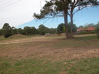
Rooty Hill is a heritage-listed historic site and now parkland at Eastern Road, Rooty Hill, City of Blacktown, New South Wales, Australia. It was built from 1802 to 1828. It is also known as The Rooty Hill and Morreau Reserve. The property is owned by the Presbyterian Church (NSW) Property Trust. It was added to the New South Wales State Heritage Register on 13 June 2007.

Plumpton, New South Wales Suburb of Sydney, New South Wales, Australia

Plumpton is located 46 kilometres west of the Sydney central business district, in the local government area of the City of Blacktown and is part of the Greater Western Sydney region.

Shanes Park, New South Wales Suburb of Sydney, New South Wales, Australia

Shanes Park is a suburb of Sydney, in the state of New South Wales, Australia. Shanes Park is located 50 kilometres west of the Sydney central business district, in the local government area of the City of Blacktown and is part of the Greater Western Sydney region.

Whalan, New South Wales Suburb of Sydney, New South Wales, Australia

Whalan is a suburb of Sydney, in the state of New South Wales, Australia. Whalan is located 44 kilometres west of the Sydney central business district, in the local government area of the City of Blacktown and is part of the Greater Western Sydney region.

Scottsdale Reserve Protected area in New South Wales, Australia

Scottsdale Reserve is a 1,328-hectare (3,280-acre) nature reserve on the Murrumbidgee River in south-central New South Wales, Australia. It is 79 kilometres (49 mi) south of Canberra, and 4 kilometres (2.5 mi) north of Bredbo. It is owned and managed by Bush Heritage Australia (BHA), which purchased it in 2006. The purchase was supportive of projects aiming to connect existing fragmented remnant habitat such as K2C. Since the 1870s up until 2006, the land was used for agriculture – primarily sheep grazing with some minor cropping. A significant component of the Reserve has been cleared of native vegetation.

Central Gardens Nature Reserve protected area in New South Wales, Australia

The Central Gardens Nature Reserve, also called Central Gardens, is a protected nature reserve located in the western suburbs of Sydney, New South Wales, Australia. Established in 1976, the 12-hectare (30-acre) reserve, garden and fauna and wildlife park is situated in the suburb of Merrylands and is managed by Cumberland Council. The park is regionally important and it attracts visitors outside the Cumberland local government area. The bushland contains remnants of Cumberland Plain Woodland and is approximately 3.5 hectares.

Nurragingy Reserve

The Nurragingy Nature Reserve is an Australian open urban park and forest, nature reserve and garden, it is a protected area owned by Western Sydney Parklands Trust and operated by Blacktown City Council that opened in 1981, the landscaped park is complete with unique features including bridges, pavilions and waterfalls, a native wildlife park, Chinese garden, New Zealand Garden, BBQ and picnic area and large conference centre for business meetings, weddings and other varying functions, it is a popular tourist attraction located in Knox Rd, Doonside and Rooty Hill, New South Wales

Queanbeyan Nature Reserve Protected area in New South Wales, Australia

The Queanbeyan Nature Reserve is a protected nature reserve that is located in the Southern Tablelands region of New South Wales, in eastern Australia. The 67-hectare (170-acre) reserve is situated approximately 4 kilometres (2.5 mi) west-south-west of the City of Queanbeyan.

Rosford Street Reserve urban park and nature reserve situated in the western suburbs of Sydney, New South Wales, Australia

Rosford Street Reserve, or Rosford Reserve, is an urban park and nature reserve situated in the western suburbs of Sydney, New South Wales, Australia. The reserve contains an open grassland, woodlands and recreational areas surrounded by native plants, such as eucalyptus trees. Janice Crosio Oval is a fenced sports ground incorporated within the reserve. The park is one of the largest in the Fairfield LGA area.

Cumberland Plain Woodland

The Cumberland Plain Woodland is one of six main indigenous woodland communities of Sydney, New South Wales, Australia, that comprises an open tree canopy, a groundcover with grasses and herbs, usually with layers of shrubs and/or small trees. Situated in the Cumberland Plain, it is made up of dry sclerophyll woodlands, grasslands and/or forests, reminiscent of Mediterranean forests and temperate grasslands. Currently, less than 6% of the Woodlands remain in small parts distributed across the western suburbs of Sydney, totaling only around 6400 hectares.

Colebee and Nurragingy Land Grant

Colebee and Nurragingy Land Grant is a heritage-listed former farm at Richmond Road, Colebee, City of Blacktown, Sydney, New South Wales, Australia. It is also known as Colebee and Nurragingy's Land Grant, Colebee Release Area, 773, 777 and 783 Richmond Road. The property is owned by Roads and Maritime Services. It was added to the New South Wales State Heritage Register on 10 February 2012.

Neoblie

Neoblie is a heritage-listed former residence at Great Western Highway, Mount Druitt, City of Blacktown, New South Wales, Australia. It was built by Charles or James Paull. The property is owned by Blacktown City Council. It was added to the New South Wales State Heritage Register on 2 April 1999.

Government Depot Site, Rooty Hill

Government Depot Site is a heritage-listed archaeological site at the location of the former Government Stock Farm at Dunsmore Street, Rooty Hill, City of Blacktown, New South Wales, Australia. It was built from 1815 to 1819 It is also known as Government Depot Site (former), Government Depot Ruins, Thornleigh, Stratton and Rooty Hill Government Farm. The property is owned by Department of Planning and Infrastructure. It was added to the New South Wales State Heritage Register on 2 April 1999.

Prospect Nature Reserve Protected area in New South Wales, Australia

Prospect Nature Reserve is a nature reserve and recreational area that is situated in the western suburbs of Sydney, New South Wales, Australia, which incorporates the Prospect Reservoir, and also features picnic spots, lookouts, walking tracks and BBQ areas within the Australian bush. It is located within the Blacktown City local government area, but is also close to the boundaries of Cumberland Council and the City of Fairfield.

Ecology of Sydney

The ecology of Sydney, located in the state of New South Wales, Australia, is diverse for its size, where it would mainly feature biomes such as grassy woodlands and some sclerophyll forests, with a few pockets of mallee shrublands, subtropical and temperate rainforests (evergreen), heathlands, and wetlands. The combination of climate, topography, moisture, and soil influence the dispersion of these ecological communities across a height gradient from 0 to 200 metres. There are many hiking trails, paved and unpaved roads for exploring the many different biomes and ecosystems.

Marne Valley Conservation Park Protected area in South Australia

Marne Valley Conservation Park is a protected area in the Australian state of South Australia located in the locality of Cambrai about 77 kilometres (48 mi) north-west of the state capital of Adelaide and about 30 kilometres (19 mi) west of the municipal seat of Mannum.

References

  1. 1 2 3 4 5 6 7 8 9 10 11 12 13 14 15 16 17 18 19 20 21 22 "The Manse". New South Wales State Heritage Register . Office of Environment and Heritage. H00206. Retrieved 1 June 2018.
  2. Pollen & Healy, 1988, 182
  3. Rappoport 2005
  4. 1 2 Sturt & Associates, 2009, 15
  5. Blacktown Advocate, 2008
  6. "The Manse". VisitBlacktown. Retrieved 16 June 2018.
  7. Sturt & Associates, 2009, 17, modified by Stuart Read, 6/1/2010

Bibliography

Attribution

CC-BY-icon-80x15.png This Wikipedia article was originally based on The Manse , entry number 00206 in the New South Wales State Heritage Register published by the State of New South Wales and Office of Environment and Heritage 2018 under CC-BY 4.0 licence , accessed on 1 June 2018.

Commons-logo.svg Media related to The Manse, Mount Druitt at Wikimedia Commons