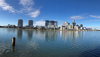
Rhodes is an Inner West suburb of Sydney, in the state of New South Wales, Australia. Rhodes is located 16 kilometres west of the Sydney central business district, in the local government area of the City of Canada Bay. It was formerly part of Concord Municipality until a merger with Drummoyne Council to form Canada Bay in December 2000.

Bondi Junction is an eastern suburb of Sydney, in the state of New South Wales, Australia. It is 6 kilometres east of the Sydney central business district and is part of the local government area of the Waverley.

Darlington is a small, inner-west suburb of Sydney, in the state of New South Wales, Australia. Darlington is located about 3 kilometres south of the Sydney central business district and is part of the local government area of the City of Sydney. At the time of its incorporation in 1864, it had the distinction of being the smallest municipality in the Sydney metropolitan area, at a mere 44 acres. Darlington is bordered by City Road, Cleveland Street, Golden Grove Street, Wilson Street and Abercrombie Street.

Chippendale is a small inner-city suburb of Sydney, New South Wales, Australia on the southern edge of the Sydney central business district, in the local government area of the City of Sydney. Chippendale is located between Broadway to the north and Cleveland Street to the south, Sydney Central railway station to the east and the University of Sydney to the west.

Broadway is a 700-metre (2,300 ft) road in inner city Sydney, New South Wales, Australia. The road constitutes the border between the suburbs of Ultimo and Chippendale. Broadway is also an urban locality.

Ultimo is an inner-city suburb of Sydney, New South Wales, Australia. Ultimo is located 2 kilometres south-west of the Sydney central business district in the local government area of the City of Sydney.
Adaptive reuse refers to the process of reusing an existing building for a purpose other than which it was originally built or designed for. It is also known as recycling and conversion. Adaptive reuse is an effective strategy for optimizing the operational and commercial performance of built assets. Adaptive reuse of buildings can be an attractive alternative to new construction in terms of sustainability and a circular economy. It has prevented thousands of buildings' demolition and has allowed them to become critical components of urban regeneration. Not every old building can qualify for adaptive reuse. Architects, developers, builders and entrepreneurs who wish to become involved in rejuvenating and reconstructing a building must first make sure that the finished product will serve the need of the market, that it will be completely useful for its new purpose, and that it will be competitively priced.

The Chinese Garden of Friendship is a heritage-listed 1.03-hectare (3-acre) Chinese garden at 1 Harbour Street, in the Sydney central business district, City of Sydney, New South Wales, Australia. Modelled after the classic private gardens of the Ming Dynasty, the garden offers an insight into Chinese heritage and culture. It was designed by Guangzhou Garden Planning & Building Design Institute, Tsang & Lee, and Edmond Bull & Corkery and built from 1986 to 1988 by Gutteridge Haskins & Davey; the Darling Harbour Authority; Imperial Gardens; Leightons; and Australian Native Landscapes. The gardens were added to the New South Wales State Heritage Register on 5 October 2018.

The Manly Dam Reserve, also known as the Manly Warringah War Memorial Park, is an urban bushland reserve located in the Northern Beaches region of Sydney, Australia. The reserve adjoins the south-eastern edge of Garigal National Park.

Central Park is a major mixed-use urban renewal project in Sydney, New South Wales, Australia located on Broadway in the suburb of Chippendale. The development is focused on a new public park located just off Broadway of approximately 6,500 square metres (70,000 sq ft) in size.

Coca-Cola Place, originally known as The Ark, is a 21 level commercial office building located at 16-40 Mount St in North Sydney, Australia. It is jointly owned by Investa Property Group and Investa Commercial Property Fund and was designed by the architectural firm Rice Daubney. Major tenants include Coca-Cola Amatil, Coca-Cola South Pacific, Vodafone Hutchison Australia, AWE Limited and Regus.
SESL Australia was established in 1983 as Sydney Environmental & Soil Laboratory by Simon Leake. SESL provides independent laboratory testing and advisory services to landscape, horticulture, sport and leisure turf, civil construction, environment, government, mining and the waste industry. It offers sample collection, monitoring, analysis and interpretation of soil, water, plant tissue and wastes. SESL also offers training courses on a range of earth science topics mainly focused on urban horticulture, sport and leisure turf, and environmental water.
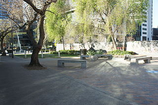
Balfour Street Park is a public pocket park located in an inner-city suburb of Sydney, in the state of New South Wales, Australia. The park is located in the suburb of Chippendale, at the corner of Balfour Street and O’Connor Street. Balfour Street Park acts as a pedestrian gateway to Central Park and was designed by the City of Sydney in collaboration with JILA, and constructed by Design Landscape for Frasers Property. It won the Horbury Hunt Brick Award for Urban Design and Landscape Architecture in 2010.

One Central Park is an award-winning mixed-use building located in Sydney, New South Wales, Australia in the suburb of Chippendale. Developed as a joint venture between Frasers Property and Sekisui House, it was constructed as the first stage of the Central Park urban renewal project.

Johnson's Building is a heritage-listed former retail stores and now stock exchange offices, bar and restaurant located at 233-235 George Street in the inner city Sydney suburb of The Rocks in the City of Sydney local government area of New South Wales, Australia. It was designed by Walter Liberty Vernon and built in 1912. It is also known as Chamber of Commerce Building and Johnson's Overalls Building (Johnsons). The property is owned by Property NSW, an agency of the Government of New South Wales. It was added to the New South Wales State Heritage Register on 10 May 2002.
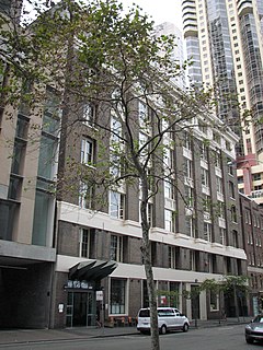
The Bushells Building is a heritage-listed former industrial building, warehouse and factory and now offices located at 121-127 Harrington Street in the inner city Sydney suburb of The Rocks in the City of Sydney local government area of New South Wales, Australia. It was designed by H. E. Ross & Rowe and built from 1924 to 1925 by A. C. Lewis Constructions. It is also known as part address 122-142 Gloucester Street (Bushell's). The property is owned by Property NSW, an agency of the Government of New South Wales. It was added to the New South Wales State Heritage Register on 10 May 2002.
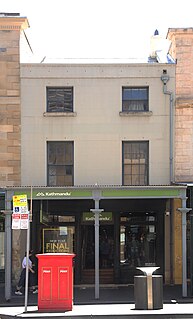
105 George Street, The Rocks is a heritage-listed shop and former residence located at 105 George Street, in the inner city Sydney suburb of The Rocks in the City of Sydney local government area of New South Wales, Australia. It was built during 1851 by persons unknown and redeveloped in 1985 by the Sydney Cove Redevelopment Authority with Co-Wyn Construction. It is also known as Kathmandu (current) and Beach Culture and Dorian Scott (former). Property NSW, an agency of the Government of New South Wales. It was added to the New South Wales State Heritage Register on 10 May 2002.

107-109 Bathurst Street, Sydney is a heritage-listed former bank building and now KFC fast food restaurant located at 107-109 Bathurst Street in the Sydney central business district, in the City of Sydney local government area of New South Wales, Australia. The property is privately owned. It was added to the New South Wales State Heritage Register on 2 April 1999.

161 Sussex Street is a heritage-listed historic site located at 161 Sussex Street, in the Sydney central business district, in the City of Sydney local government area of New South Wales, Australia. The property is owned by Property NSW, an agency of the Government of New South Wales. It was added to the New South Wales State Heritage Register on 2 April 1999.
Phoenix Central Park is a private performing arts venue and art gallery located at 37-49 O'Connor Street, Chippendale, New South Wales, Australia. The building is due for completion in early 2020. The location is within the Chippendale Heritage Conservation Area (HCA), item ‘C9’ on Schedule 5 of the Sydney Environmental Plan (LEP) 2012. The site is also within the Chippendale Locality as described in Section 2.3.1 of the Sydney Development Control Plan (DCP) 2012.


