
The River Severn, at 220 miles (354 km) long, is the longest river in Great Britain. It is also the river with the most voluminous flow of water by far in all of England and Wales, with an average flow rate of 107 m3/s (3,800 cu ft/s) at Apperley, Gloucestershire. It rises in the Cambrian Mountains in mid Wales, at an altitude of 2,001 feet (610 m), on the Plynlimon massif, which lies close to the Ceredigion/Powys border near Llanidloes. The river then flows through Shropshire, Worcestershire and Gloucestershire. The county towns of Shrewsbury, Gloucester and Worcester lie on its course.

Offa's Dyke Path is a long-distance footpath loosely following the Wales–England border. Officially opened on 10 July 1971, by Lord Hunt, it is one of Britain's National Trails and draws walkers from throughout the world. About 60 miles (97 km) of the 177-mile (285 km) route either follows, or keeps close company with, the remnants of Offa's Dyke, an earthwork traditionally thought to have been constructed in the late 8th century on the orders of King Offa of Mercia.

Powys is a county and preserved county in Wales. It borders Gwynedd, Denbighshire, and Wrexham to the north; the English ceremonial counties of Shropshire and Herefordshire to the east; Monmouthshire, Blaenau Gwent, Merthyr Tydfil, Caerphilly, Rhondda Cynon Taf, and Neath Port Talbot to the south; and Carmarthenshire and Ceredigion to the west. The largest settlement is Newtown, and the administrative centre is Llandrindod Wells.

The Bristol Channel is a major inlet in the island of Great Britain, separating South Wales and South West England. It extends from the smaller Severn Estuary of the River Severn to the North Atlantic Ocean. It takes its name from the English city and port of Bristol.

Until 1974, Montgomeryshire was an administrative county in mid Wales, later classed as one of the thirteen historic counties of Wales. It was named after its county town, Montgomery, which in turn was named after one of William the Conqueror's main counsellors, Roger de Montgomerie, who was the 1st Earl of Shrewsbury.

Afon Rheidol is a river in Ceredigion, Wales, 19 miles (31 km) in length. The source is Plynlimon. Receiving an average annual rainfall of 40 inches (1.02 m), Plynlimon is also the source of both the Wye and the Severn.

St George's Bridge was a bridge over the River Severn in Shrewsbury, England; so named as it was close to the medieval St George's Hospital. It connected Frankwell, an old suburb of the town, to the town centre via Mardol. The gate on the town side was called Mardol Gate and is located where the Mardol Quay Gardens are. The gate on the other side was called Welsh Gate or St George's Gate. The bridge, sometimes now known as the Old Welsh Bridge, was demolished in 1795 and was replaced with the Welsh Bridge.

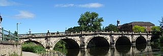
The Welsh Bridge is a masonry arch viaduct in the town of Shrewsbury, England, which crosses the River Severn. It connects Frankwell with the town centre. It is a Grade II* listed building.
The English Bridge is a masonry arch viaduct, crossing the River Severn in Shrewsbury, Shropshire. The present bridge is a 1926 rebuilding and widening of John Gwynn's design, completed in 1774. A bridge is known to have stood at this spot since at least Norman times. Historically, it was known as the "Stone Bridge". It is a Grade II* listed building.

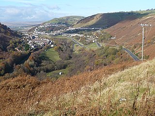
The Ebbw River is a river in South Wales which gives its name to the town of Ebbw Vale. The Ebbw River is joined by the Ebbw Fach River at Aberbeeg. The Ebbw Fach is itself fed by a left-bank tributary, the River Tyleri.
The Rhymney River is a river in the Rhymney Valley, South Wales, flowing through Cardiff into the Severn Estuary. The river formed the boundary between the historic counties of Glamorgan and Monmouthshire until in 1887, the parishes east of the river, Rumney and St Mellons, were transferred from the jurisdiction of Newport, to Cardiff in Glamorgan.

The River Rea is a small river that flows through south east Shropshire, England.

The River Onny is a river in Shropshire, England. It is a major tributary of the River Teme.

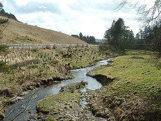
The River Carno is a river in Powys, mid Wales, and a tributary of the River Severn.
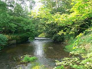
Cound Brook is a tributary of the River Severn in Shropshire, England, running to south of the county town Shrewsbury. The Cound Brook rises in the Stretton Hills, and enters the River Severn at Eyton on Severn after winding its way for 22 miles (35 km) across the southern Shropshire-Severn plain. This length is measured from high on the Long Mynd.
The River Ithon is a major left-bank tributary of the River Wye in Powys, mid Wales. It rises in the broad saddle between the western end of Kerry Hill and the hill of Glog to its west and flows initially southwards to Llanbadarn Fynydd. It then takes a twisting route south via the villages of Llanbister, Llanddewi Ystradenny and Penybont before turning southwest, then doubling back northwards towards Crossgates. From here it resumes a southwesterly course, flowing past Llandrindod Wells and the site of Cefnllys Castle to a confluence with the Wye, 1 mile to the south of Newbridge-on-Wye.
The Battle of Buttington was fought in 893 between a Viking army and an alliance of Anglo-Saxons and Welsh.

Daer Water is one of the streams located in the watershed region which surrounds the River Clyde in Scotland. It begins in the Lowther Hills about 600 metres (2,000 ft) above sea level and joins with Potrail Water near the Lanarkshire town of Elvanfoot at which point they become the River Clyde. The Daer Water flows through the Daer Reservoir which supplies water to the nearby towns of Lanarkshire.

The River Rhiw is a short river in the north of Powys in Wales. Two headwater tributaries both named Afon Rhiw flow east to join at Dwyrhiew and then continue in a generally easterly direction to join the River Severn east of Berriew. The northern Rhiw emerges from Llyn y Bugail on Mynydd Waun Fawr whilst the southern Rhiw rises near Mynydd Dwyriw. The combined river flows past the hamlets of New Mills, Manafon and Pant-y-ffridd, accompanied by the B4390 road all the way to Berriew. Other tributaries include the Nant Wtre-wen, Crygnant, Nant y Llyn Mawr and Dolgar Brook. It is bridged and forded at numerous points, one of which is an aqueduct carrying the Montgomery Canal over it at Berriew. At the eastern end of the river is Glansevern Hall and gardens.
The Vale of Montgomery is an area of low land straddling the border between Shropshire, England and the former county of Montgomeryshire, Wales. The three principal settlements within it are the former county town of Montgomery and the village of Churchstoke, both in Wales, and Chirbury in England. The earthworks of Offa's Dyke run NNW-ESE through the middle of the vale and are followed by the Offa's Dyke Path. The national boundary also follows this monument for 3 km within the vale. The River Camlad rises to the southeast of the vale whilst its tributary the Caebitra rises to its southwest. They combine at Churchstoke and flow north within a gorge along the eastern margin of the vale, before turning west across the north end of the vale to join the River Severn.
