
The Kenya African National Union (KANU) is a Kenyan political party that ruled for nearly 40 years after Kenya's independence from British colonial rule in 1963 until its electoral loss in 2002. It was known as Kenya African Union (KAU) from 1944 but due to pressure from the colonial government, KAU changed its name to Kenya African Study Union (KASU) mainly because all political parties were banned in 1939 following the start of the Second World War. In 1946 KASU rebranded itself into KAU following the resignation of Harry Thuku as president due to internal differences between the moderates who wanted peaceful negotiations and the militants who wanted to use force, the latter forming the Aanake a forty, which later became the Mau Mau. His post was then occupied by James Gichuru, who stepped down for Jomo Kenyatta in 1947 as president of KAU. The KAU was banned by the colonial government from 1952 to 1960. It was re-established by James Gichuru in 1960 and renamed KANU on 14 May 1960 after a merger with Tom Mboya's Kenya Independence Movement.
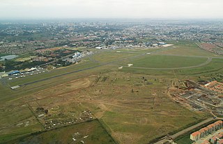
Wilson Airport is an airport in Nairobi, Kenya. It has flights to many regional airports in Kenya while Nairobi's main airport, Jomo Kenyatta International Airport, serves domestic and many international destinations.

Kenyatta University (KU) is a public research university with its main campus in Nairobi, Kenya. It acquired the status of university in 1985, being the third university after University of Nairobi (1970) and Moi University (1984). As of October 2014, it was one of 23 public universities in the country.

Westlands is a mixed-use neighbourhood in Upper Parklands in Nairobi. Located 3.0 kilometres (2 mi) from Nairobi's central business district, it sits on the westerly areas of the larger Parklands area of Nairobi.
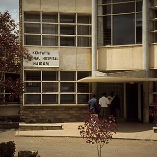
The Kenyatta National Hospital is the oldest hospital in Kenya. It is a public, tertiary, referral hospital for the Ministry of Health. It is also the teaching hospital of the University of Nairobi College of Health Sciences. It is the largest hospital in the country and East Africa as well.

I&M Bank Kenya Limited, is a commercial bank in Kenya, the largest economy in the East African Community. It is licensed by the Central Bank of Kenya, the central bank and national banking regulator.

Chase Bank Kenya Limited(CBK), commonly referred to as Chase Bank, was a commercial bank in Kenya, licensed by the Central Bank of Kenya, the central bank and national banking regulator.
Kingdom Bank Limited (Kenya), formerly Jamii Bora Bank, is a commercial bank in Kenya. It is one of the commercial banks licensed by the Central Bank of Kenya, the national banking regulator.
Kenya Commercial Bank Plaza (KCB Plaza) is a building in Nairobi, the capital and largest city of Kenya. Construction began in December 2010 and the building was completed in 2015.
The Kisumu massacre occurred when the presidential guard and police forces shot and killed several civilians in Kisumu Town, the capital of Nyanza Province in Kenya. This took place on 25 October 1969. The official death toll from government sources stands at 11 fatalities but other sources place this number at closer to 100. Victims included women and children, some of whom were shot 30–50 km away from the epicentre of the riots. According to media reports, the government of the day attempted to cover up the extent of the massacre.
Brookside Dairy Limited, often referred to as Brookside Dairies, is a dairy processing company in Kenya, the largest economy in the East African Community. The company offers fresh pasteurized milk, cream, butter, yogurt, ghee, and long life milk products in Indian Ocean Islands, East Africa, Rwanda and Burundi. It provides products through distribution depots, agents, and sub agents to outlets in East Africa.
Mavueni is a neighborhood in the city of Kilifi, in Kenya's Kilifi County.
Kenyatta University Hospital is a National Referral Hospital with a 650-bed capacity. The hospital is equipped to offer specialized Oncology, Trauma & Orthopedics, Renal, Accident & Emergency, among other services but the oncology center is its flagship project. The hospital was officially opened by President Uhuru Kenyatta on 10th of September 2020 though it had been in operation since October 2019. The hospital has an integrated molecular imaging center which helps in the treatment and diagnosis of cancer, one of the major reasons Kenyans travel abroad to seek.
The Olkaria IV Geothermal Power Station is an operational geothermal power plant in Kenya, with installed capacity of 140 megawatts (190,000 hp).
Housing Finance Group of Kenya (HFGK), also Housing Finance Group Limited (HFGL), is a financial services holding company based in Kenya. HFGK maintains its headquarters in Nairobi, the capital and largest city, with subsidiaries and branches in major urban centers in the country.
Kenyatta University Solar Power Station is a 10 MW (13,000 hp) solar power plant under construction in Kenya.
Cytonn Towers is a planned mixed-use skyscraper development, consisting of three towers of 35 storeys each, in Nairobi, Kenya's capital and largest city. The development is targeted towards the upper middle class, non-governmental organisations and diplomatic missions.

The Kenya Coast Guard Service is a specialized maritime force of the Republic of Kenya, responsible for law enforcement on national waters, including on the oceans, lakes and rivers. The force is mandated to maintain maritime safety, security, pollution control and sanitation. It is also responsible for apprehending and prosecuting offenders.
The Nairobi Expressway is a 27 kilometres (17 mi) toll road in Kenya, connecting Jomo Kenyatta International Airport to Nairobi's Westlands area, that has been constructed under a public-private partnership between the government of Kenya and China Road and Bridge Corporation (CRBC).
Clement Michael George Argwings-Kodhek, also known as Chiedo Moa Gem Argwings-Kodhek, was a Kenyan attorney and politician. He served in the government and cabinet of Jomo Kenyatta, Kenya's first president, for six years, during which time he held the post of member of parliament for the Gem Constituency and the portfolios of Minister of Natural Resources and the Ministry of Foreign Affairs.
