
Market Harborough is a market town in the Harborough district of Leicestershire, England, close to the border with Northamptonshire. The population was 24,779 at the 2021 census. It is the administrative headquarters of the Harborough district.

Harborough is a local government district in Leicestershire, England. It is named after its main town, Market Harborough, which is where the council is based. The district also includes the town of Lutterworth and numerous villages and surrounding rural areas. In the north of the district it includes parts of the Leicester Urban Area, notably at Thurnby, Bushby and Scraptoft. Covering 230 square miles (600 km2), the district is the largest by area of the eight districts in Leicestershire and covers almost a quarter of the county.

East Farndon is a small linear village and civil parish about one mile south of Market Harborough in West Northamptonshire, England. The village is close to the border with Leicestershire, and has a Leicestershire post code and telephone dialling code. At the time of the 2001 census, the parish's population was 258 people, increasing to 307 at the 2011 census.

Welford is a village and civil parish in the West Northamptonshire unitary authority area of Northamptonshire, England, just south of the River Avon and the border with Leicestershire. At the 2011 Census, the population of the parish was 1,043.
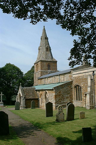
Arthingworth is a civil parish and village in the West Northamptonshire area of the county of Northamptonshire, England. The population of the civil parish at the 2011 census was 238.

Maidwell is a village and civil parish in West Northamptonshire in England. At the time of the 2001 census, the parish had 325 inhabitants, including Draughton, and this increased to 429 at the 2011 census.

Lilbourne is a village and civil parish in West Northamptonshire in England. It is close to the M1 motorway which runs east of the village, and the A5 road, west of the village which marks the boundary with Warwickshire, slightly to the north is the River Avon which marks the boundary with Leicestershire. At the time of the 2001 census, the parish's population was 254 people, increasing to 273 at the 2011 Census, and further to 305 at the 2021 census.

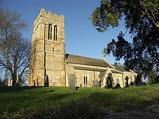
Clipston is a village and civil parish in West Northamptonshire, England. The village lies around 4 miles (6.4 km) south-southwest of the town of Market Harborough in the neighbouring county of Leicestershire. At the 2011 Census, the population of the parish was 643, an increase from 613 at the 2001 Census.
Wilbarston is a village and civil parish in the English county of Northamptonshire in the Welland valley. It is administered as part of North Northamptonshire and is five miles east of the Leicestershire town of Market Harborough, via the A427. At the time of the 2001 census, the parish's population was 767 people, including Pipewell but reducing slightly to 753 at the 2011 Census. A Community Governance Review concluded in February 2015 resulted in the ward of Pipewell becoming part of the civil parish of Rushton.

Great Bowden is a village and civil parish in the Harborough district of Leicestershire, England. It is north-east of and a suburb of Market Harborough, although originally the parish of Great Bowden included Harborough. The population is around 1,000, being measured at the 2011 census as 1,017. Places nearby include Market Harborough, Little Bowden, Sutton Bassett, Foxton and Thorpe Langton.

Great Easton is a village and civil parish in the Harborough district of Leicestershire, England. The parish had a population of 558 according to the 2001 census, increasing to 671 at the 2011 census.

East Langton is a village and civil parish in the Harborough district of Leicestershire, England.

Slawston is a village and civil parish in the Harborough district of Leicestershire, England, north-east of Market Harborough. According to the 2001 census the parish had a population of 143, including Welham and increasing to 191 at the 2011 census. The parish includes the deserted village of Othorpe at grid reference SP770956. Slawston is located roughly 1 km away from Medbourne.
Ashley is a village and civil parish in North Northamptonshire, England, about 4 miles (6.4 km) northeast of Market Harborough, Leicestershire and 5 miles (8.0 km) west of Corby. The population of the civil parish at the 2011 Census was 224, an increase from 217 at the 2001 Census. The village is near the River Welland, which forms the border with Leicestershire. The Roman road called Via Devana in the part from Ratae to Duroliponte ran just north of the village.

Medbourne is a village and civil parish in the Harborough district, in the county of Leicestershire, England. The population of the civil parish at the 2011 census was 473.

Little Bowden is an area on the edge of Market Harborough and former civil parish in the Harborough district, in the county of Leicestershire, England. As a village it was formerly part of Northamptonshire. The River Jordan runs through part of the area.
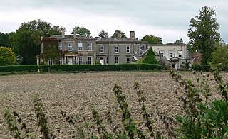
Hothorpe Hall, in Northamptonshire, is a Georgian manor house near Market Harborough. It lies in the parish of Marston Trussell in Northamptonshire but is close to Theddingworth in Leicestershire. The hall is currently used as a conference centre and wedding venue.
North Kilworth is a village and civil parish in the Harborough district, in south Leicestershire, England, north of South Kilworth. The population of the civil parish at the 2011 census was 597. Largely bypassed by the A4304 road, the village consists of a mix of old and new housing and includes a primary school and the parish church of St. Andrew's dating from the 13th century.
South Kilworth is a village and civil parish in the southern part of Leicestershire, England, south of North Kilworth. The parish has a population of 430, according to the 2001 Census, and is part of the district of Harborough. The population had risen to 513 at the 2011 census.

